
Stoneman Military Trail facts for kids

The Stoneman Road was a very important supply route in Arizona. It connected two forts: Fort McDowell and Fort Whipple in Prescott. This road was used between 1870 and 1890. It helped move supplies from Prescott to Fort McDowell, which was located near what is now Fountain Hills on the Yavapai Reservation.
Contents
History of the Stoneman Road


Fort McDowell was built in 1865. It often ran low on supplies. Before the Stoneman Road, getting supplies was hard. The path between the forts was very long. It went south through Phoenix and then north to Prescott. This long trip wasted a lot of time.
Building the New Road
When the Stoneman Road was built, it saved a whole day of travel. The new route was named after Colonel George Stoneman. He was 48 years old and a veteran of the Civil War. Colonel Stoneman had a long career in the Army. He had also studied at West Point.
Colonel Stoneman came to Arizona in May 1870. He only stayed for one year. But building this road was a big achievement during his time there. Stoneman was a true explorer. He wanted to find a shorter way to Prescott. He found his route by following an old Native American trail. This trail already covered part of the distance.
The Road's Path
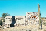
The trail was made wider and turned into a rocky road. It went northwest from Fort McDowell. It passed through what is now McDowell Mountain Regional Park. The road also went north of Pinnacle Peak. People think soldiers might have camped near where 136th Street and Rio Verde Drive are today.
The road then went near a place that would later be Brown’s Ranch. It also touched the eastern edge of where The Boulders resort is now. This area is in north Scottsdale. From there, it passed the northern side of Black Mountain. Then it continued west to Cave Creek. A small spring near what is now Rancho Manana was a good resting spot. Travelers could get water there.
After that, the road went north along Cave Creek. It crossed into what is now Cave Creek Regional Park. From there, it went through the New River Mountains and Black Canyon. Finally, it continued north through Mayer to Fort Whipple and Prescott.
Fort McDowell Closes

On April 10, 1890, the U.S. military left Fort McDowell. The fort then became the Fort McDowell Indian Reservation. This reservation was home to the Mohave, Pima, and Apache tribes.
After 1890, the Stoneman Road was not used much. Over time, the Arizona weather and nature took over. Now, only small parts of the road are left.
Finding Parts of the Old Road
A group of history experts has found parts of the road. They found sections in McDowell Mountain Park. They also found some near the old Brown’s Ranch in north Scottsdale. Another clear section runs between Stagecoach Pass at Windmill Road. It goes northwest to Cave Creek Road. This part ends near a gate going into the Carefree Airport.
There is also a short section of the Military Road. It runs east to west, south of Cave Creek Road. This part was once connected to the old Stoneman Road. It originally went towards Cave Creek. It passed by what people believe was a military horse station from the 1870s to 1890s. Other than these small parts, most of the road has disappeared over time.
Stoneman Trail in Fountain Hills Today
The Stoneman Trail is also known as the Stoneman Wash Trail. You can find it in the McDowell Mountains in Fountain Hills, Arizona.
-
-
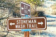
Sign showing where the Stoneman Trail, also called Stoneman Wash Trail, passes through the McDowell Mountains in Fountain Hills.
-
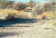
The Stoneman Trail, also called Stoneman Wash Trail


