
Fort McDowell, Arizona facts for kids
Quick facts for kids
Fort McDowell, Arizona
|
|
|---|---|

Location where Fort McDowell once stood
|
|

Fort McDowell, Arizona
Location in Arizona

Fort McDowell, Arizona
Location in the United States
|
|
| Country | United States |
| State | Arizona |
| County | Maricopa |
| Elevation | 1,440 ft (439 m) |
| Population | |
| • Total | 600 |
| Time zone | UTC-7 (Mountain (MST)) |
| • Summer (DST) | UTC-7 (MST) |
| ZIP code |
85264
|
| Area code(s) | 480 |
| FIPS code | 04-24810 |
| GNIS feature ID | 29117 |
Fort McDowell is a small community in Arizona, United States. It's located in Maricopa County, about 23 miles northeast of the big city of Phoenix. This area has its own post office with the ZIP code 85264.
Contents
The Story of Fort McDowell
Why Was Fort McDowell Built?
Fort McDowell started as "Camp McDowell" in 1865. It was built by soldiers called the California Volunteers. They set up the camp near the Verde River to protect important travel routes. These routes were used by settlers and traders.
The fort was named after a famous general, Irvin McDowell. It was built in an area known as Indian country. The main goal was to protect the routes from the Apache people. The Apache lived in the Gila River and Salt River valleys nearby.
Life at the Fort
Some Native Americans in the region chose not to live on reservations. They preferred to stay in the mountains. These groups often traveled in small numbers. Their presence sometimes worried settlers. Because of this, another military outpost, Camp Verde, was also built. It helped protect trade routes in the area.
Fort McDowell was close to many trails important to the Apache of central Arizona. The soldiers at the fort often had military exercises against groups like the Tonto Apache. The first buildings at the fort were not very strong. They were washed away by heavy summer monsoon rains soon after they were built.
Connecting Forts with Trails
A special path called the Stoneman Military Trail was very important. It connected Fort McDowell to Fort Whipple in Prescott, Arizona. This trail was used to bring supplies to the fort. It was used for many years, from 1870 to 1890.
What's the Climate Like?
Fort McDowell has a semi-arid climate. This means it's usually very dry, but it does get some rain. It's not a desert, but it's not a humid place either. On climate maps, this type of weather is shown as "BSk".
Historic Places at Fort McDowell
Many interesting ruins and sites remain from the original Fort McDowell. These places tell stories about the past.
- Fort McDowell Ruins
-
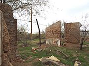
The remaining ruins of the Fort McDowell officers quarters located in Ba Hon Nah Road.
-
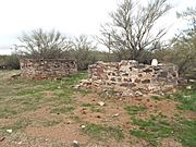
Fort McDowell ruins located in Fort Loop Road.
-
The ruins of one of the buildings which belonged to the original Fort McDowell.
-
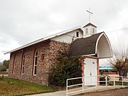
Fort McDowell Church located in Fort Loop Road.
-
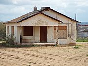
Abandoned house in the land of the Fort McDowell Yavapai Nation.
-
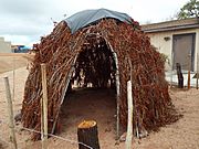
An early Wickiup or hut which served as a home of a Yavapai family.
-
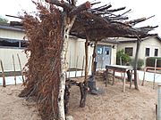
Yavapai resting area.
-
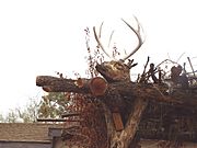
Deer Head on top of the Yavapai resting area.
-
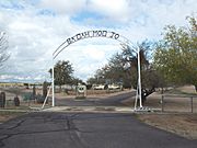
Entrance of the as "Ba Dah Mod Jo" Cemetery also known as the Fort McDowell Yavapai Nation Cemetery.
-
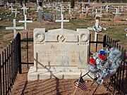
The grave of Carlos Montezuma or Wassaja in "Ba Dah Mod Jo" Cemetery. Montezuma was a Yavapai-Apache Native American, activist and a founding member of the Society of American Indians. His birth name Wassaja, means "Signaling" or "Beckoning" in his native tongue. He was the first Native American male to receive a medical degree.
-
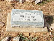
The grave of Mike Burns, whose real name was Hoo-moo-thy-ah. He was the cousin of Carlos Montezuma. When he was a child he led the US Cavalry to Skeleton Cave where he witnessed the massacre of his people.
-
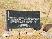
Grave dedicated to the men, women and children who were massacred by the soldiers of the US Army in Skeleton Cave.
-
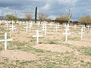
Unidentified graves of the Yavapai who perished during the "Indian Wars”.
-
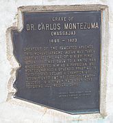
Dr. Carlos Montezuma plaque.
-
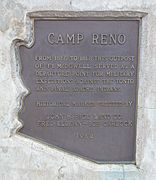
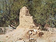
Marker which indicates where the historic Camp Reno was located.
-
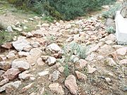
Camp Reno ruins. Camp Reno was a lookout post for Fort McDowell.


