Stony Brook (Charles River tributary, Boston) facts for kids
Quick facts for kids Stony Brook |
|
|---|---|
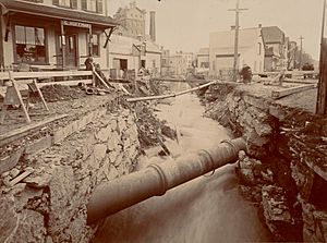
Stony Brook in Jamaica Plain in 1898
|
|
| City | Boston, Massachusetts, United States |
| Physical characteristics | |
| Main source | Turtle Pond, Stony Brook Reservation 42°15′56″N 71°08′30″W / 42.265499°N 71.1418°W |
| River mouth | Charles River Basin 42°21′07″N 71°05′32″W / 42.35187°N 71.092215°W |
| Length | 8.5 miles (13.7 km) |
Stony Brook is a stream in Boston, Massachusetts. It's about 8.5 miles long and mostly flows underground in special tunnels called conduits. Stony Brook is the biggest stream that feeds into the lower Charles River.
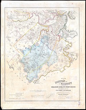
The brook starts at Turtle Pond in the Stony Brook Reservation. From there, it flows through different parts of Boston like Hyde Park, Roslindale, Jamaica Plain, and Roxbury. It finally empties into the Charles River Basin near the Harvard Bridge. Stony Brook has four smaller streams that feed into it, and they are also mostly underground.
Long ago, Stony Brook flowed freely and helped power factories. Its clean water even attracted breweries! But when it rained a lot, the brook would flood the areas around it. Because of this, people started putting parts of the brook into underground conduits. This began in 1851 in Roxbury. By 1867, most of the northern part of Stony Brook was hidden underground. More tunnels were built in the 1870s and 1880s to control the water flow better.
In the early 1900s, new conduits were built to send the water directly to the Charles River. This helped prevent flooding and made the area safer. Over time, almost all of Stony Brook was put underground, except for the first mile. In recent years, efforts have been made to clean up the water, making the Charles River much healthier.
Contents
Where Does Stony Brook Flow?
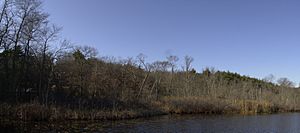
Stony Brook begins at Turtle Pond, which is inside the Stony Brook Reservation park. It flows above ground for about one mile through the park. After that, it goes into a conduit near Enerking Parkway and Gordon Avenue.
The conduit then winds its way under homes and follows the Northeast Corridor train tracks for almost a mile. It continues north through Hyde Park, Roslindale, and Jamaica Plain, mostly staying close to the railroad. Some streets, like American Legion Highway, are built right over the hidden brook.
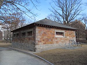
Further north, the conduit runs under streets like Gurney Street and Parker Street. You can see two stone buildings called gatehouses near the Back Bay Fens. These gatehouses help control the water. From there, the conduit goes north to the Charles River Basin. Stony Brook's water flows into the Charles River just before the Harvard Bridge. Usually, about 10 cubic feet of water flow per second, but during big storms, it can be more than 100 times that!
Stony Brook's Tributaries
Stony Brook used to have four main smaller streams that fed into it. Today, all of these are also partly or completely underground:
- Goldsmith Brook: This brook has two parts that flow between Jamaica Pond and the Arnold Arboretum. They join together and meet Stony Brook near Boylston Street.
- Bussey Brook: This stream runs next to the VFW Parkway and through the Arboretum. It meets Stony Brook at Forest Hills. Most of it is above ground, except at its beginning and end.
- Roslindale Branch: This branch starts in West Roxbury and flows parallel to the Needham Line train tracks. It joins Stony Brook east of Roslindale Square.
- Canterbury Brook: This stream flows west from near Codman Square and meets Stony Brook near Neponset Avenue. It gets some water from Scarborough Pond in Franklin Park and has a part that flows above ground along American Legion Highway.
How Stony Brook Changed Over Time
Early Changes to the Brook
Originally, Stony Brook was a winding stream that flowed into the Muddy River and the Back Bay. People liked its clear water, and many breweries and factories used it for their businesses. Roads and railroads were also built along the Stony Brook valley.
However, the valley was very flat. When it rained heavily or snow melted, the brook would overflow and flood the nearby land. As more buildings were put up, this flooding became a big problem.
So, people started putting the brook into culverts (underground tunnels). A small part was put into a culvert by 1845. In 1851, a section in Roxbury was put underground. Streets were built over these new tunnels, and the land was sold for new buildings. By 1867, most of the brook north of Roxbury Crossing was covered.
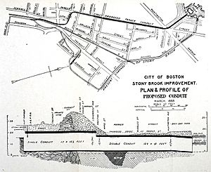
More tunnels were built in Jamaica Plain and Roslindale in the 1870s and 1880s. In 1881–82, a large conduit was built to send heavy flows directly to the Charles River. But even with these changes, a big flood in 1886 showed that the tunnels weren't big enough.
Building New Channels for Health
From 1887 to 1889, a new bypass tunnel, called the Commissioner's Channel, was built. It was very large and helped manage storm water. The famous landscape architect Frederick Law Olmsted designed the Back Bay Fens to act as a basin to hold extra water from Stony Brook during storms.
Around the 1890s, the railroad tracks in the Stony Brook Valley were raised to remove dangerous street crossings. This project also involved building deeper and longer conduits for the brook. People realized that controlling Stony Brook was very expensive!
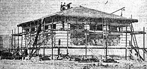
By 1897, all of Stony Brook's water was sent into the Commissioner's Channel and into the Fens. However, there were problems with sewage getting into the brook, which then polluted the Fens. To fix this, a new, even bigger conduit was built from 1903 to 1905. This new tunnel carried all of Stony Brook's water directly to the Charles River. A second gatehouse was built to control this flow. The old canal that led to the Fens was then filled in.
In 1909, the Charles River Dam was built, which changed the Charles River from saltwater to freshwater. This meant another conduit had to be built along the Charles River Esplanade, and a third gatehouse was added. By this time, Boston had spent over $5 million (a huge amount back then!) to control Stony Brook.
Over the years, efforts continued to reduce pollution from factories and sewage in Stony Brook. A big project from 2000 to 2006 installed many new storm drains. This reduced sewage flowing into Stony Brook during storms by a lot, which has greatly improved the water quality in the Charles River.
Extending the Underground Sections South
The Stony Brook Reservation, where the brook starts, became a park in 1894. The rest of the river, from Hyde Park to Jamaica Plain, was slowly put into conduits over many years.
Work to extend the conduit south began in 1897 and reached Green Street by 1901. It was extended further to Forest Hills Square in 1910–11. Around 1921, more sections were added, including a conduit for the Roslindale Branch.
The last parts of the brook that were still above ground in Roslindale and Hyde Park (outside the park) were put into conduits between the 1930s and 1950s. Roads were built over some of these new underground sections. For example, Brookway Road was built over a culvert south of Forest Hills in 1951. When the new underground Forest Hills station was built in the 1980s, the conduit there was moved even deeper underground.
 | May Edward Chinn |
 | Rebecca Cole |
 | Alexa Canady |
 | Dorothy Lavinia Brown |


