Strelley Village facts for kids
Quick facts for kids Strelley |
|
|---|---|
 All Saints' Church |
|
Map |
|
| Population | 496 (2021) |
| OS grid reference | SK 50695 41928 |
| • London | 110 mi (180 km) SSE |
| District |
|
| Shire county | |
| Region | |
| Country | England |
| Sovereign state | United Kingdom |
| Post town | NOTTINGHAM |
| Postcode district | NG8 |
| Dialling code | 0115 |
| Police | Nottinghamshire |
| Fire | Nottinghamshire |
| Ambulance | East Midlands |
| EU Parliament | East Midlands |
| UK Parliament |
|
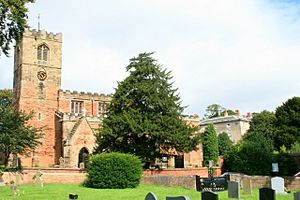
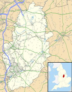
Strelley is a small village in Nottinghamshire, England. It is located to the west of the city of Nottingham. Strelley is also the name of a nearby housing area built after World War II.
The village of Strelley is mostly in the Borough of Broxtowe, which is a local government area. A small part of the village crosses into the city of Nottingham. The housing area, however, is completely inside the city of Nottingham. A road called the A6002 separates the old village from the newer housing area. In 2021, about 496 people lived in the village.
Contents
What is Strelley Village Like?
The village of Strelley was first mentioned in a very old book called the Domesday Book in 1086. Back then, it was called Straleia. This name likely means 'a clearing on a street or Roman road'. Even though the name suggests a Roman road, no one has found one in the area.
A Quiet Place to Live
Strelley village feels quite peaceful and hidden away. This is because it is not on a main road that lots of cars use to pass through. However, there were old paths for horses and walkers, called bridleways. These paths connected Strelley to other nearby places like Cossall and Kimberley.
The village still has an old pub called the Broad Oak. A pub is a place where people can meet and relax. This pub has been updated a bit but still keeps some of its old charm.
Strelley's Coal Mining Past
Strelley is famous for having one of the earliest railway lines in the world. This line was called the Wollaton Waggonway. It was built in 1604 and connected Strelley to Wollaton. On this railway, horse-drawn wagons carried coal on wooden tracks. This type of early railway is known as a wagonway.
The Wollaton Waggonway was built by Huntingdon Beaumont, who worked with Sir Percival Willoughby. Coal mining was a very important industry in Strelley during the times of Queen Elizabeth I and King James I. Important families like the Strelleys and the Byrons were involved in the early coal mining here.
In the 1960s, a large part of Strelley was used for a huge opencast coal mine. This is where coal is dug up from the surface of the ground. After the mine closed, the M1 motorway was built over the western part of the area. Today, you can easily see the village church, All Saints' Church, Strelley, from the motorway. It is just north of the Trowell services area.
Strelley's Location and Features
The main television transmitter for Nottingham is located in the Strelley area. This transmitter helps send TV signals to homes in Nottingham. It is also known as Swingate, named after a nearby farm.
The transmitter is close to the border of the Kimberley area and the Robin Hood Way. The Robin Hood Way is a long-distance walking path. The base of the transmitter is about 130 meters high. It is also near a trig point at Windmill Farm. A trig point is a special marker used for surveying land.
 | Dorothy Vaughan |
 | Charles Henry Turner |
 | Hildrus Poindexter |
 | Henry Cecil McBay |


