
Struve Geodetic Arc facts for kids
The Struve Geodetic Arc is a very long chain of survey points that stretches across Europe. It goes all the way from Hammerfest in Norway down to the Black Sea. This amazing chain is over 2,820 kilometers (about 1,750 miles) long and passes through ten different countries!
This special chain was created and used by a scientist named Friedrich Georg Wilhelm von Struve. He worked on it from 1816 to 1855. His main goal was to find the exact size and shape of the Earth. When he built it, the chain crossed only two large areas: the Union of Sweden-Norway and the Russian Empire. The very first point of the Arc is at the Tartu Observatory in Estonia. This is where Struve did a lot of his important research.
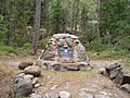
In 2005, the Struve Geodetic Arc was added to the World Heritage List by UNESCO. This means it's a very important place that should be protected for everyone to learn about. Out of the original 265 survey points, 34 are still marked today with special plaques or obelisks.


Quick facts for kids Struve Geodetic Arc |
|
| Ensemble of memorable sites | |
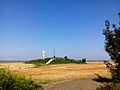
 The northernmost station of the Struve Geodetic Arc is located in Fuglenes, Norway.
|
|
| Countries | Estonia, Belarus, Finland, Latvia, Lithuania, Norway, Moldova, Russia, Sweden, Ukraine |
|---|---|
| Landmarks | Fuglenes, Staro-Nekrassowka |
| Seas | Arctic Ocean, Baltic Sea, Black Sea |
| Coordinates | 59°3′28″N 26°20′16″E / 59.05778°N 26.33778°E |
| Length | 2,820,000 m (9,251,969 ft), north-south |
| Author | Friedrich Georg Wilhelm von Struve |
| Founded | Geodetic Arc |
| Date | 1855 |
| UNESCO World Heritage Site | |
| Name | Struve Geodetic Arc |
| Year | 2005 (#29) |
| Number | 1187 |
| Region | Europe and North America |
| Criteria | ii, iii, vi |
What is a Geodetic Arc?
A geodetic arc is like a giant measuring tape used to map the Earth. Scientists use a method called triangulation to do this. Imagine a series of triangles connected together. By accurately measuring the angles and one side of each triangle, they can figure out the distances between many points.
This method helps create very precise maps and understand the Earth's shape. The Struve Geodetic Arc was a huge step forward in mapping because it was the first time such a long and accurate measurement of a meridian arc was made. A meridian arc is a line that runs from the North Pole to the South Pole.
Why Was it Built?
In the 1800s, scientists wanted to know the exact size and shape of our planet. They knew the Earth was round, but they needed to measure it more precisely. Was it a perfect sphere, or was it a bit flattened at the poles and bulging at the equator?
Friedrich Georg Wilhelm von Struve led this massive project. By carefully measuring the distances and angles along this long arc, he could gather the data needed to calculate the Earth's true shape. His work proved that the Earth is indeed slightly flattened at the poles, like a squashed ball. This was a very important discovery for science!
Countries Along the Arc
The Struve Geodetic Arc passes through ten different countries today. These countries are:
Each of these countries has at least one of the original survey points that are now part of the World Heritage Site. These points are often marked with special stones, pillars, or plaques.
Images for kids
-
Hogland Z
-
The commemorative plaque of the arc in Felshtyn, Ukraine.


See also
 In Spanish: Arco Geodésico de Struve para niños
