Sunwapta Peak facts for kids
Quick facts for kids Sunwapta Peak |
|
|---|---|

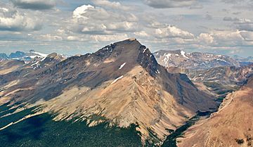
South Face of Sunwapta Peak seen from Tangle Ridge
|
|
| Highest point | |
| Elevation | 3,315 m (10,876 ft) |
| Prominence | 1,014 m (3,327 ft) |
| Listing | Mountains of Alberta |
| Geography | |
| Parent range | Canadian Rockies |
| Topo map | NTS 83C/06 |
| Climbing | |
| First ascent | 1906 by Jimmy Simpson |
| Easiest route | Easy scramble |
Sunwapta Peak is a tall mountain found in Jasper National Park in Alberta, Canada. It sits in the beautiful Sunwapta River valley, just north of the huge Columbia Icefield. People named the peak in 1892. Its name comes from the Stoney language word "sunwapta," which means "turbulent river." You can easily spot this mountain from the famous Icefields Parkway (Highway 93).
Climbing Sunwapta Peak
If you want to climb Sunwapta Peak, the easiest way is an "easy scramble." This means it's a climb that doesn't usually need special ropes or gear. You start your climb from a trail right next to the Icefields Parkway. To reach the top, you'll climb about 1,735 meters (5,692 feet) higher than where you started.
How Sunwapta Peak Was Formed
Sunwapta Peak is made of sedimentary rock. This type of rock forms when layers of sand, mud, and tiny bits of plants and animals settle over time. These layers were laid down over millions of years, from the Precambrian to the Jurassic periods. Later, during an event called the Laramide orogeny, huge forces pushed these rocks up. This movement caused older rock layers to slide over younger ones, creating the mountain we see today.
Weather at Sunwapta Peak
Sunwapta Peak is in a subarctic climate zone. This means it has very cold, snowy winters and mild summers. Temperatures can drop below -20 °C ( -4 °F). With the wind, it can feel even colder, sometimes below -30 °C (-22 °F). The snow and ice that melt from Sunwapta Peak flow into the Sunwapta River. This river then flows into the larger Athabasca River.
 | Ernest Everett Just |
 | Mary Jackson |
 | Emmett Chappelle |
 | Marie Maynard Daly |


