Suquamish, Washington facts for kids
Quick facts for kids
Suquamish, Washington
|
|
|---|---|

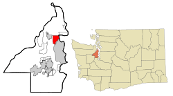
Location of Suquamish, Washington
|
|
| Country | United States |
| State | Washington |
| County | Kitsap |
| Area | |
| • Total | 7.6 sq mi (19.7 km2) |
| • Land | 6.8 sq mi (17.7 km2) |
| • Water | 0.8 sq mi (2.0 km2) |
| Elevation | 66 ft (20 m) |
| Population
(2020)
|
|
| • Total | 4,266 |
| • Density | 560.9/sq mi (216.5/km2) |
| Time zone | UTC-8 (Pacific (PST)) |
| • Summer (DST) | UTC-7 (PDT) |
| ZIP code |
98392
|
| Area code(s) | 360 |
| FIPS code | 53-69170 |
| GNIS feature ID | 1508848 |
Suquamish is a community in Kitsap County, Washington, USA. It is called a "census-designated place" (CDP) because the government counts its population for official records. In 2020, about 4,266 people lived there.
Suquamish is very important to the Suquamish tribe. It is part of the Port Madison Indian Reservation. This is also where Chief Seattle is buried. Long ago, the Suquamish tribe had their main winter home, called the Old Man House, in this area.
Location and Land
Suquamish is located in the northern part of Kitsap County. It sits across Agate Passage from Bainbridge Island. The main village area of Suquamish is in the northeast.
A road called Washington State Route 305 goes through the southern part of Suquamish. This road crosses the Agate Pass Bridge to Bainbridge Island. It also goes west about 4 miles (6.4 km) to the town of Poulsbo.
The United States Census Bureau says that the Suquamish area covers about 7.6 square miles (19.7 square kilometers). Most of this area, about 6.8 square miles (17.7 square kilometers), is land. The rest, about 0.8 square miles (2.0 square kilometers), is water.
People of Suquamish
| Historical population | |||
|---|---|---|---|
| Census | Pop. | %± | |
| 2000 | 3,510 | — | |
| 2010 | 4,140 | 17.9% | |
| 2020 | 4,266 | 3.0% | |
| Sources: | |||
In 2000, there were 3,510 people living in Suquamish. They lived in 1,459 homes, and 948 of these were families. The population density was about 513 people per square mile (198 people per square kilometer).
Most people in Suquamish were White (81.3%). About 9.6% were Native American, and 2.4% were Asian. Some people were from other backgrounds, including 3.1% who were Hispanic or Latino.
About 30% of the homes had children under 18 living there. Many homes (52%) were married couples living together. The average home had 2.4 people, and the average family had 2.9 people.
The population included people of all ages:
- 24.2% were under 18 years old.
- 29.3% were between 25 and 44 years old.
- 12.9% were 65 years or older.
The average age was 40 years old.
In 2000, the average income for a home in Suquamish was $46,667 per year. For families, the average income was $55,759 per year. About 8.5% of all people, and 6.2% of families, lived below the poverty line.
Schools in Suquamish
Chief Kitsap Academy is a school located in Suquamish.
There was once another school here called the Northwest College of Art & Design. It used to be in a building known as Mains Manor. In 2017, the Suquamish tribe bought this building. They turned it into the Chief Kitsap Building, which is now part of the Chief Kitsap Academy.
See also
 In Spanish: Suquamish (Washington) para niños
 | Jessica Watkins |
 | Robert Henry Lawrence Jr. |
 | Mae Jemison |
 | Sian Proctor |
 | Guion Bluford |

