Swasey Mountain facts for kids
Quick facts for kids Swasey Peak |
|
|---|---|

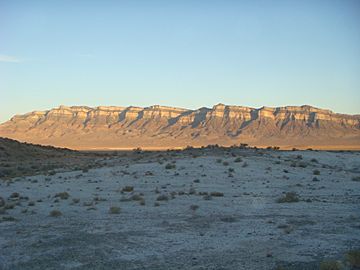
View of west flank, from Tule Valley
|
|
| Highest point | |
| Elevation | 9,673 ft (2,948 m) NAVD 88 |
| Prominence | 4,509 ft (1,374 m) |
| Geography | |
| Parent range | Swasey Mountain, House Range |
| Topo map | USGS Swasey Peak |
| Geology | |
| Mountain type | limestone, upper elevations |
| Climbing | |
| Easiest route | Swasey Peak from north & northeast, Sawmill Basin Canyon, (west Sevier Desert) Robbers Roost (at Tatow Knob) Robbers Roost Canyon, west Sevier Desert |
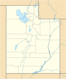
Swasey Mountain is a mountain located in Utah, United States. It forms the northern part of the House Range. Most of Swasey Mountain is in Millard County, but its northern tip reaches into Juab County.
Contents
What is Swasey Mountain?
Swasey Mountain has a long ridge on its western side that stretches for about 14 miles. The southern part of the mountain is shaped a bit like the letter "L". This southern section is a large, solid block of rock, with a rounder part connected to its southeast side.
High Points of the Mountain
The very highest point on Swasey Mountain is called Swasey Peak. It stands at 9,673 feet (2,948 meters) tall. Swasey Peak is located in the southwest corner of the mountain's "L" shape. Another important high point is Tatow Knob, which is 8,416 feet (2,565 meters) tall. Tatow Knob is found closer to the middle of the mountain's northern ridge.
Who Was Swasey Mountain Named After?
Swasey Mountain gets its name from a rancher named Charles Swasey.
Neighboring Areas
To the west of Swasey Mountain is a flat area called Tule Valley. East of the mountain, you'll find the Sevier Desert. To the northeast, there are the Drum Mountains. The northern end of Swasey Mountain is right next to the southern end of the Fish Springs Range. Both of these ranges run in a north-south direction.
 | Sharif Bey |
 | Hale Woodruff |
 | Richmond Barthé |
 | Purvis Young |


