
Sweers Island facts for kids


Sweers Island is a beautiful island located in the South Wellesley Islands. You can find it in the Gulf of Carpentaria, which is part of Queensland, Australia. This island is managed by the Shire of Mornington.
Contents
Where is Sweers Island?
Sweers Island is about 8 kilometres (5 miles) long. It's located just 3 kilometres (1.9 miles) east of Bentinck Island, which is the biggest island in the South Wellesley group. If you travel north from Burketown, a town on the Queensland mainland, Sweers Island is about 70 kilometres (43 miles) away.
A Look at Sweers Island's Past
Sweers Island has a rich history, including connections to the Kayardild language and early explorers. The Kayardild people have lived in the Gulf of Carpentaria area for a very long time. Their language region includes the land around the Mornington Shire Council.
How Sweers Island Got Its Name
The island was named by a famous explorer named Matthew Flinders. On November 16, 1802, Flinders named the island after Salomon Sweers. Sweers was an important person in the East India Company. He was one of the people who told another explorer, Abel Tasman, to explore the Gulf of Carpentaria way back in 1644.
Matthew Flinders was on a big journey, sailing all the way around Australia in his ship, the HMS Investigator. He wanted to map the coastline and find out if Australia was one big island or several smaller ones.
Early Settlements and Challenges
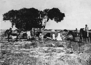
In 1865, a man named Robert Towns started a settlement called Burketown. This town was a base for his large land holdings in the Gulf Country. However, Burketown faced many problems because of tropical diseases, like typhoid fever.
At one point, a ship arrived in Burketown from Sydney, carrying a fever. Many people on board died. Believing Burketown was unhealthy, William Landsborough moved most of the survivors to Sweers Island. They stayed there for 18 months, and only two more people died. Later, Towns and Co. used Sweers Island to trade goods like wool and animal hides with places like Batavia.
The Famous Investigator Tree
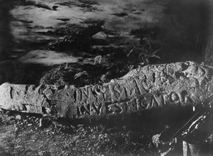
In 1841, another explorer, John Lort Stokes, visited Sweers Island. He was the commander of the ship Beagle. Stokes found a special tree on the island. It had the word "Investigator" carved into it by Matthew Flinders during his visit in 1802! This tree became known as "The Investigator Tree."
Stokes also carved the name "Beagle" into the tree. Over the years, other explorers and visitors added their names too. These included Augustus Charles Gregory in 1856 and William Landsborough in 1861.
Sadly, a powerful cyclone hit the island on March 5, 1887. It badly damaged the tree. To save a piece of this important history, part of the tree's trunk was moved to the Queensland Museum in 1889.
Fun Things to Do on Sweers Island
Sweers Island is a great place for outdoor activities! Many people enjoy fishing and watching the local wildlife.
Fishing Adventures
Fishing is very popular here. The most common fish caught for eating is the sweetlip. You can also find other tasty fish species like coral trout, red emperor, golden snapper, nannygai, and parrot fish.
During the winter, even more types of fish can be caught. These include fast-swimming fish like Spanish mackerel, grey mackerel, giant trevally, giant leatherskin, queenfish, northern bluefin tuna, and cobia. If you want to stay on the island, the Sweers Island Resort offers places to sleep, meals, and boats for fishing.
Getting to Sweers Island
The island has its own airstrip, which is 1,100 metres (3,600 feet) long. This gravel airstrip can be used in all kinds of weather, making it easier for visitors to reach the island.
