Sydney River facts for kids
Quick facts for kids Sydney River |
|
|---|---|

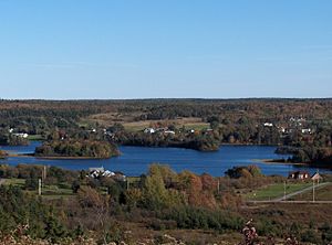
Sydney River, with Coxheath in the foreground and Howie Centre on the opposite bank
|
|
| Other name(s) | Spanish River |
| Country | Canada |
| Province | Nova Scotia |
| County | Cape Breton |
| District | Cape Breton Regional Municipality |
| City | Sydney |
| Physical characteristics | |
| Main source | Blacketts Lake |
| River mouth | South Arm of Sydney Harbour between the Westmount shore near Amelia Point and Battery Point on the Sydney shore 0 m (0 ft) 46°8′49.4″N 60°13′36.3″W / 46.147056°N 60.226750°W |
| Length | 12.5 km (7.8 mi) |
| Basin features | |
| Basin size | 140 km2 (54 sq mi) |
| Tributaries |
|
| Bridges | 125 Highway, Route 305 |
| Inland ports | Port of Sydney |
The Sydney River is a small river found in Cape Breton County, Nova Scotia, Canada. Long ago, in the 1700s, the French called it the Spanish River. This name came from its wide mouth, which they called Baie d’Espagnols.
The river helps separate several communities. On its north side are Coxheath and Westmount. On the south and east sides, you'll find Howie Centre, Sydney River, and the city of Sydney.
Contents
Where the Sydney River Flows
The Sydney River starts its journey in Blacketts Lake. From there, it flows for about 12.5 km (7.8 mi) (about 7.8 miles). It ends its path at the South Arm of Sydney Harbour. This is between the Westmount shore and Battery Point in Sydney.
The river collects water from a large area called a watershed. This watershed covers about 140 km2 (54 sq mi) (54 square miles). It stretches south from the top of the Coxheath Hills. Over 2,000 homes are located within this watershed.
For the last 7 km (4.3 mi) (about 4.3 miles) of its length, the Sydney River is an estuary. This means it's a place where fresh river water mixes with salty ocean water.
The Sysco Dam
In 1902, a structure called the "Sysco Dam" was built on the river. This dam changed the river a lot. The part of the river just above the dam used to be an estuary, but the dam turned it into a freshwater reservoir lake. This lake holds fresh water, which is different from the salty water found closer to the ocean.
How the Valley Was Formed
The valley where the Sydney River flows was shaped by glaciers long ago. Glaciers are like giant sheets of ice that move slowly across the land. As they moved, they left behind thick layers of dirt and rocks.
You can still see features left by these glaciers, such as kames (small hills of sand and gravel) and eskers (long, winding ridges). These features created a series of shallow lakes connected by narrow channels.
A Path for the Mi'kmaq People
This low valley was very important to the Mi'kmaq people. They used it as a traditional portage route. A portage is a path where people carry their canoes and goods between two waterways. The Mi'kmaq used this route to travel between Sydney Harbour and the East Bay of Bras d'Or Lake.
Unique Wildlife in the River
The Sydney River is special because it is one of only two watersheds in Canada where a specific type of mussel lives. This mussel is called the yellow lampmussel.
These yellow lampmussels are found in the river above the 1902 dam. The dam actually helped them by creating more freshwater habitat. This increased the area where the lampmussels could live and thrive in the river's watershed.
 | Janet Taylor Pickett |
 | Synthia Saint James |
 | Howardena Pindell |
 | Faith Ringgold |

