
São Vicente, Cape Verde facts for kids
|
Native name:
Sonsent
Nickname: Ilha do Porto Grande (island of Porto Grande)
|
|
|---|---|
 |
|
 |
|

São Vicente
Location in Cape Verde

São Vicente
Location in Atlantic Ocean
|
|
| Geography | |
| Location | Atlantic Ocean |
| Coordinates | 16°51′N 24°58′W / 16.850°N 24.967°W |
| Area | 226.7 km2 (87.5 sq mi) |
| Length | 24.3 km (15.1 mi) |
| Width | 16.3 km (10.13 mi) |
| Highest elevation | 744 m (2,441 ft) |
| Highest point | Monte Verde |
| Administration | |
| Municipality | São Vicente |
| Largest settlement | Mindelo |
| Demographics | |
| Population | 81,014 (2015) |
| Pop. density | 357 /km2 (925 /sq mi) |
São Vicente is an island in Cape Verde, a country in the Atlantic Ocean near West Africa. Its name means "Saint Vincent" in Portuguese. It is part of the Barlavento Islands, which are the northern islands of Cape Verde. São Vicente is located between the islands of Santo Antão and Santa Luzia. A channel called Canal de São Vicente separates it from Santo Antão.
Contents
- Exploring São Vicente's Geography
- São Vicente's History
- How São Vicente is Governed
- São Vicente's Population
- São Vicente's Economy
- Education on São Vicente
- Language on São Vicente
- Famous People from São Vicente
- Getting Around São Vicente
- Culture of São Vicente
- Sports on São Vicente
- Sister Cities
- Images for kids
- See also
Exploring São Vicente's Geography
São Vicente island is shaped like a rectangle. It covers an area of about 226.7 square kilometers (87.5 square miles). From east to west, it is about 24.3 kilometers (15.1 miles) long. From north to south, it is about 16.3 kilometers (10.1 miles) wide.
The island was formed by volcanoes, but it is mostly flat now. The last time a volcano was active here was a very long time ago. Even though the island has been worn down by weather, some old volcano craters can still be seen.
The highest point on the island is Monte Verde. It is located in the eastern part and stands 744 meters (2,441 feet) tall. Other mountains include Madeiral (680 m), Caixa (535 m), and Monte Cara (490 m).
Most of the people on the island, about 92.6%, live in the city of Mindelo. Mindelo is located on the Porto Grande Bay. This bay is actually an old volcano crater that the ocean has filled. A small island called Ilhéu dos Pássaros is close to Porto Grande Bay. São Vicente also has a few streams that flow only sometimes, like Ribeira do Calhau and Ribeira de Julião.
São Vicente's Climate
São Vicente has a hot desert climate. This means it is very dry and warm. The average temperature in Mindelo is about 23.6°C (74.5°F) each year. The island gets very little rain, only about 127 millimeters (5 inches) per year in Mindelo. Only the higher areas, like Monte Verde, get more rain.
| Climate data for Mindelo (1981-2010) | |||||||||||||
|---|---|---|---|---|---|---|---|---|---|---|---|---|---|
| Month | Jan | Feb | Mar | Apr | May | Jun | Jul | Aug | Sep | Oct | Nov | Dec | Year |
| Record high °C (°F) | 29.2 (84.6) |
29.5 (85.1) |
30.3 (86.5) |
29.5 (85.1) |
31.5 (88.7) |
30.5 (86.9) |
33.6 (92.5) |
31.8 (89.2) |
32.7 (90.9) |
31.5 (88.7) |
31.0 (87.8) |
30.0 (86.0) |
33.6 (92.5) |
| Mean daily maximum °C (°F) | 23.4 (74.1) |
23.2 (73.8) |
23.9 (75.0) |
24.0 (75.2) |
24.9 (76.8) |
25.4 (77.7) |
27.1 (80.8) |
28.3 (82.9) |
28.8 (83.8) |
28.0 (82.4) |
26.8 (80.2) |
25.2 (77.4) |
25.7 (78.3) |
| Daily mean °C (°F) | 21.9 (71.4) |
21.6 (70.9) |
22.0 (71.6) |
22.2 (72.0) |
22.8 (73.0) |
23.8 (74.8) |
25.0 (77.0) |
26.2 (79.2) |
26.5 (79.7) |
26.0 (78.8) |
25.0 (77.0) |
23.3 (73.9) |
23.9 (75.0) |
| Mean daily minimum °C (°F) | 19.9 (67.8) |
19.7 (67.5) |
19.6 (67.3) |
20.2 (68.4) |
20.9 (69.6) |
21.9 (71.4) |
22.9 (73.2) |
24.1 (75.4) |
24.8 (76.6) |
24.2 (75.6) |
23.2 (73.8) |
21.7 (71.1) |
21.9 (71.4) |
| Record low °C (°F) | 16.5 (61.7) |
13.5 (56.3) |
15.6 (60.1) |
15.0 (59.0) |
15.0 (59.0) |
18.0 (64.4) |
17.5 (63.5) |
14.5 (58.1) |
19.0 (66.2) |
18.5 (65.3) |
19.0 (66.2) |
17.0 (62.6) |
13.5 (56.3) |
| Average rainfall mm (inches) | 4.8 (0.19) |
1.7 (0.07) |
0.4 (0.02) |
0.4 (0.02) |
0.0 (0.0) |
0.0 (0.0) |
2.6 (0.10) |
16.3 (0.64) |
36.2 (1.43) |
14.5 (0.57) |
6.3 (0.25) |
1.0 (0.04) |
84.2 (3.33) |
| Average rainy days (≥ 0.1 mm) | 1 | 1 | 0 | 0 | 0 | 0 | 1 | 4 | 5 | 2 | 2 | 2 | 18 |
| Average relative humidity (%) | 66.1 | 67.6 | 67.2 | 68.2 | 70.1 | 72.9 | 72.7 | 74.0 | 74.2 | 72.8 | 69.4 | 67.3 | 70.2 |
| Mean monthly sunshine hours | 229.4 | 237.3 | 275.9 | 291.0 | 306.9 | 276.0 | 248.0 | 226.3 | 225.0 | 238.7 | 225.0 | 201.5 | 2,981 |
| Mean daily sunshine hours | 7.4 | 8.4 | 8.9 | 9.7 | 9.9 | 9.2 | 8.0 | 7.3 | 7.5 | 7.7 | 7.5 | 6.5 | 8.2 |
| Source 1: Instituto Nacional de Meteorologia e Geofísica | |||||||||||||
| Source 2: Deutscher Wetterdienst (extremes, precipitation days, and sun) | |||||||||||||
São Vicente's History

The Portuguese explorer Diogo Afonso discovered São Vicente on January 22, 1462. This day is also Saint Vincent's Day. At first, the island did not have much water. So, it was mainly used for grazing cattle.
In 1732, São Vicente became part of the Municipality of Santo Antão. At that time, no one lived there permanently. People started to settle in the Porto Grande Bay area in 1793.
The island's population grew quickly after 1838. This was when a coal storage area was built at Porto Grande Bay. It was used to refuel ships traveling across the Atlantic Ocean.
However, by the early 1900s, the port of Mindelo became less important. This happened for a few reasons. Ships started using oil instead of coal for fuel. Also, other ports like Dakar and the Canary Islands became popular. Plus, there was not enough money invested in improving Mindelo's port.
How São Vicente is Governed
São Vicente island is managed by one local government area. This area is called Concelho de São Vicente. This municipality has one main civil parish, Nossa Senhora da Luz, which covers the entire island. The main city and government center is Mindelo.
The civil parish is divided into several smaller communities:
- Baía das Gatas
- Lameirão
- Mindelo (city)
- Monte Verde
- Norte da Baía
- Ribeira da Vinha
- Ribeira de Calhau
- Ribeira Julião
- Salamansa
- São Pedro
Leaders of São Vicente
Here are some of the people who have led the municipality of São Vicente:
- Henrique Teixeira de Sousa, in the 1960s
- Onésimo Silveira, in the late 1990s and early 2000s
- Isaura Gomes 2004–2005 and 2008–2011
- Augusto Neves (since 2011)
São Vicente's Population

In the 1830s, São Vicente had about 356 people. By 2010, the population had grown to 76,140. This makes it the second most populated island in Cape Verde, after Santiago. The population grows by about 1.3% each year.
Most people, 92.6%, live in cities. This is the highest percentage of city dwellers among all the islands in Cape Verde. People on São Vicente live long lives, with an average life expectancy of 76 years.
The island has a young population. About 49% of the people are under 25 years old. Only 7.4% are over 65. There are about 19,923 homes on the island. Each home has about 3.8 people living in it. In 2010, about 15.1% of homes owned a car.
| Year | Population |
|---|---|
| 1940 |
15,848
|
| 1950 |
19,576
|
| 1960 |
20,705
|
| 1970 |
31,578
|
| 1980 |
41,594
|
| 1990 |
51,277
|
| 2000 |
67,844
|
| 2010 |
76,140
|
| 2015 |
81,014
|
São Vicente's Economy

The economy of São Vicente mostly relies on commerce (buying and selling goods) and services. Because there is not much rain, farming is mainly for people to grow their own food. Fishing is important, especially for lobster. There are also industries that process fish, like making conserves or drying and salting fish. Building and repairing ships is also part of the economy.
Porto Grande is the most important port in Cape Verde. Many of the country's imported goods pass through here. The port has special areas for containers, storage, and refrigeration. This helps handle a lot of cargo. There is also a modern plant that turns seawater into fresh drinking water. This water is used by people and for shipyards.
The island has many workers, but not all of them have special skills. About 27% of the people who work are unskilled. People with high qualifications, like company leaders or managers, make up less than 2% of workers. However, more women hold decision-making jobs here than in other parts of Cape Verde.
In 2010, São Vicente had the highest unemployment rate in Cape Verde, at 14.8%. The national average was 10.7%. More women than men faced unemployment. The island's industrial area, the Industrial Zone of the Lazareto, has different types of factories. These factories mainly make shoes, clothes, and process fish. Many of these businesses are from other countries.
The National Center of Workmanship in Mindelo helps local artists. They make and sell things like ceramic items, products from coconut shells, and necklaces made of shells and rocks.
Many sports are popular on São Vicente and have spread to other islands. The island is great for windsurfing. São Pedro beach is considered one of the best places for windsurfing. Many world champions have trained there. You can also explore the island by cycling, walking, or horseback riding. São Vicente even has an excellent 18-hole golf course. Because of these activities, tourism has a lot of potential to grow on São Vicente and in Cape Verde.
Getting around the island is easy. Public transportation is run by five private companies. For places farther from Mindelo, like Baía das Gatas, Calhau, and São Pedro, people often rent vans or buses.
Education on São Vicente
Most people on São Vicente can read and write, with a literacy rate of 85%. Among young people in Cape Verde, 98.9% can read and write. About 54% of the island's population, aged 1 to 12 years old, are in school.
Here are the types of schools and how many students they have:
- Preschool – There are 25 daycares, mostly private. About 2,600 children aged 1 to 6 attend them.
- Primary Schools (grades 1 to 6) – There are 11,000 students in 225 classrooms with 379 teachers.
- Secondary Education (grades 7 to 12) – There are 8,000 students in 146 classrooms with 384 teachers.
Schools and Learning Centers
The island has 35 primary schools. Many of these are in Mindelo, but there are also schools in Calhau, Salamansa, and São Pedro.
There are five main public secondary schools. In the 2004–05 school year, 8,350 students attended them:
- Liceu Ludjero Lima, with 2,384 students
- Escola Industrial E Comercial Do Mindelo, with 2,245 students
- Escola Secundária Jorge Barbosa, with 1,593 students
- Escola Secundária José Augusto Pinto, with 1,385 students
- Escola Salesiana, with 743 students
Private Schools
- Académica do Mindelo
- Wille
- Centro Técnico Do Mindelo
- Cooperativa Ensino Técnico Do Mindelo
- Cruzeiro
Higher Education
For students who want to continue their education after secondary school, São Vicente has several options:
- University of Cape Verde, which has a Faculty of Engineering and Maritime Sciences and a School of Business and Governance.
- University of Mindelo – This is Cape Verde's third university.
- Instituto Superior de Ciências Económicas Empresariais
- Instituto Superior de Educação (campus), part of the University of Cape Verde
- Jean Piaget University of Cape Verde (campus)
- Mindelo Escolas Internacional de Artes (Mindelo International School of Arts)
- Universidade Lusófona
Research and Science Centers
São Vicente is also home to important research centers. These include the INDP Instituto Nacional de Desenvolvimento das Pescas and the Cape Verde Ocean Observatory (CVOO). There is also the CVAO, the Cape Verde Atmospheric Observatory. This observatory works with universities and institutes from the UK and Germany.
Language on São Vicente
The main language spoken on São Vicente is Portuguese. However, most people also speak Cape Verdean Creole. The version of Creole spoken on São Vicente is called Crioulo de São Vicente in Portuguese or Kriol d Sonsent in Creole.
- Rules for writing São Vicentean Kriol
- Creole-French Dictionary
Famous People from São Vicente
Many talented people come from São Vicente. Here are some of them:
- Carlos Alhinho, football player and coach
- Alexandre Alhinho, football player and coach
- Leonel Almeida, singer
- Bana, singer
- Bau, musician
- B. Leza, singer and composer
- Valter Borges, footballer
- Bela Duarte, artist
- Dulce Almada Duarte (b. 1933), linguist
- Cesária Évora, singer
- Fantcha, singer
- Sérgio Ferreira (1946–2006), writer
- Corsino Fortes (1933–2015), writer
- Sergio Frusoni, poet
- João Cleofas Martins, photographer and humorist
- Vasco Martins, composer
- Georgina Mello, general director of CPLP nations
- Luís de Montalvor (1891–1947), also known as Luís da Silva Ramos, Portuguese poet
- Yolanda Morazzo (b. 1926), poet and writer
- Tito Paris (b. 1968)
- Erin Pinheiro, footballer
- Rambé, footballer
- Onésimo Silveira, poet, diplomat and political activist
- Ovídio de Sousa Martins, poet
- Adriano Spencer, footballer
- Fredson (Fredson Tavares), footballer
- Carlos Veiga (b. October 21, 1949), former Prime Minister of Cape Verde
- Lela Violão (Manuel Tomás da Cruz), singer and composer
- Fredson Gomes, taekwondo athlete
Getting Around São Vicente
The island has an international airport called Cesária Évora Airport. It is located near São Pedro in the southwest. The port of Mindelo, Porto Grande, is the busiest port in Cape Verde. You can take ferries from here to the islands of Santo Antão, São Nicolau, Santiago, and Sal.
There is one main national road on the island, which goes from the airport to Mindelo. There are also other national roads of different classes. Mindelo has a bus system that connects most of its neighborhoods to the city center. Transcor SV SA operates most of these bus lines.
Culture of São Vicente
In the late 1800s and early 1900s, when the port was busy, São Vicente was a center of culture in Cape Verde, along with Santiago. Many books and poems from the mid-1900s were about the rise of national pride and the fight for the country's independence. A famous magazine from that time was Claridade. São Vicente is also the birthplace of coladeira music. A type of morna music is also very popular here.
Sports on São Vicente
São Vicente has its own football (soccer) league called the São Vicente Island League. There are also competitions for basketball, volleyball, futsal, and athletics. There is a golf course about 2 to 3 kilometers (1.2 to 1.9 miles) south of Mindelo.
Sister Cities
The municipality of São Vicente has special partnerships with several cities in Portugal. These are called twin towns or sister cities:
Images for kids
-
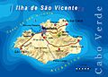
Map of São Vicente
-
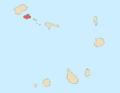
Location of São Vicente in Cape Verde
See also
 In Spanish: Isla de São Vicente para niños
