
Tópaga facts for kids
Quick facts for kids
Tópaga
|
||
|---|---|---|
|
Municipality and town
|
||

View of Tópaga
|
||
|
||

Location of the municipality and town of Tópaga in the Boyacá Department of Colombia
|
||
| Country | ||
| Department | Boyacá Department | |
| Province | Sugamuxi Province | |
| Founded | 6 March 1593 | |
| Founded by | Álvaro Leiva | |
| Area | ||
| • Municipality and town | 37 km2 (14 sq mi) | |
| • Urban | 6.4 km2 (2.5 sq mi) | |
| Elevation | 2,900 m (9,500 ft) | |
| Population
(2015)
|
||
| • Municipality and town | 3,694 | |
| • Density | 99.8/km2 (259/sq mi) | |
| • Urban | 1,406 | |
| Time zone | UTC-5 (Colombia Standard Time) | |
| Website | Official website: http://www.topaga-boyaca.gov.co/ | |
.svg)
Tópaga is a small town and a special area called a municipality in Colombia. It is located in the Boyacá Department, which is like a state. Tópaga is found in the Sugamuxi Province.
The town sits on a high plain called the Altiplano Cundiboyacense. The center of Tópaga is about 2,900 meters (9,500 feet) above sea level. The land around the town varies in height, from 2,400 meters (7,900 feet) to 3,200 meters (10,500 feet).
Tópaga shares its borders with several other towns. To the west, it borders Nobsa and Corrales. To the east, it borders Mongua and Gámeza. Gámeza is also to the north, and Monguí and Sogamoso are to the south. The capital city of the Boyacá Department, Tunja, is about 98 kilometers (61 miles) away. The Chicamocha River flows through the area of Tópaga.
Contents
What Does Tópaga Mean?
The name Tópaga comes from an old language called Chibcha. In this language, Tópaga means "Behind father river." This name tells us a bit about the history and geography of the area.
A Look at Tópaga's History
Before the Spanish arrived in Colombia, the area of Tópaga was home to the Muisca. They were an important group of people in ancient Colombia. The Muisca village of Tópaga was led by a local chief, known as a cacique. This chief had the same name as the village.
The cacique of Tópaga was loyal to a very important spiritual leader called the iraca of Sugamuxi. The Muisca people believed their iraca was taught by a messenger god named Bochica. This was part of their traditional beliefs.
Modern Tópaga was officially started on March 6, 1593. It was founded by a person named Álvaro Leiva.
How Tópaga Makes Money
The main way people in Tópaga earn a living is through coal mining. Coal is a type of rock that can be burned for energy. The coal mined in Tópaga is used to make electricity. This makes coal mining a very important job for the town.
Gallery
-
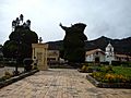
Central square
-
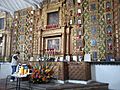
Chapel interior


Panorama of Tópaga

See also
 In Spanish: Tópaga para niños
