Türkmenabat facts for kids
Quick facts for kids
Turkmenabat
Türkmenabat
Түркменабат
Leninsk 1924-1927 Çärjew 1940-1999 |
|
|---|---|
|
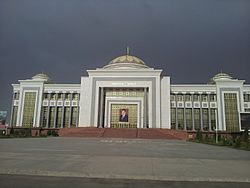
Ruhyýet Palace (above), Marble buildings along the street Bitarap Turkmenistan (left)
City’s East Side (right) |
|
| Country | |
| Province | Lebap Province |
| Elevation | 187 m (614 ft) |
| Population
(2009 census)
|
|
| • Total | 253,000 |
| Time zone | UTC+5 |
| Postal code |
746100
|
| Area code(s) | +993 422 |
| Vehicle registration | LB |
Türkmenabat (Turkmen: Türkmenabat, Түркменабат) is the second-largest city in Turkmenistan. It is the main city of Lebap Province.
The city has had a few names over time. It was once called Amul. Later, it was known as Cärjew or Chardzhou for many years. From 1924 to 1927, it was named Leninsk. As of 2009, about 254,000 people lived there.
Contents
What's in a Name?
The old name, Çärjew (Chardzhou), comes from a Persian word. It means "four brooks." This kind of name is common in some places.
The current name, Türkmenabat, is a mix of two words. "Türkmen" refers to the Turkmen people. The ending "ābād" means "cultivated place," like a village or city. So, Türkmenabat means "the city of Turkmens."
Where is Türkmenabat?
Türkmenabat is located about 187 meters (614 feet) above sea level. It sits on the banks of the Amu Darya River. This river is very important to the region.
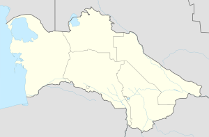
The city is close to the border with Uzbekistan. It's in the middle of Lebap province. This province shares borders with three other provinces in Turkmenistan: Mary, Ahal, and Daşoguz. It also borders Uzbekistan and Afghanistan.
About 70 kilometers (43 miles) south of Türkmenabat is the Repetek Nature Reserve. This reserve is famous for its zemzen, which are desert crocodiles.
A Look Back in Time
Türkmenabat is a modern city today, but its history goes back 2,000 years. In ancient times, it was known as Āmul. The Amu Darya River is even named after this old city.
Türkmenabat was a very important stop on the Great Silk Road. This was a famous trade route. Three main paths of the Silk Road met here, leading to cities like Bukhara, Khiva, and Merv. For many centuries, Āmul was a key town in the Uzbek kingdom of Bukhara.
When the Russian Empire started to take over parts of Central Asia, Āmul became part of Russia. The modern city was started in 1886. Russian soldiers settled in an area called Uralka. They named their new settlement New-Chardjuy. This settlement was needed to help build the Trans-Caspian railway.
After the Russian Revolution in 1917, new countries were formed. In 1924, Türkmenabat (then called Chardjuy) became part of the new Turkmen Soviet Socialist Republic. This was because the new Turkmen country needed a large city for its plans.
Because it was a railway junction and had fertile land near the Amu Darya River, Türkmenabat became a major trade center. It was known for farm products. The city had factories that processed food and made textiles, like cotton and silk. During the Soviet period, Çärjew was a big industrial and transport hub.
Weather in Türkmenabat
Türkmenabat has a cool desert climate. This means it has cool winters and very hot summers. It doesn't rain much, and when it does, it's usually in winter and spring.
| Climate data for Türkmenabat (1991–2020, extremes 1894-present) | |||||||||||||
|---|---|---|---|---|---|---|---|---|---|---|---|---|---|
| Month | Jan | Feb | Mar | Apr | May | Jun | Jul | Aug | Sep | Oct | Nov | Dec | Year |
| Record high °C (°F) | 24.0 (75.2) |
28.4 (83.1) |
35.9 (96.6) |
40.3 (104.5) |
42.9 (109.2) |
46.4 (115.5) |
46.2 (115.2) |
43.0 (109.4) |
40.4 (104.7) |
37.3 (99.1) |
31.9 (89.4) |
26.6 (79.9) |
46.4 (115.5) |
| Mean daily maximum °C (°F) | 7.9 (46.2) |
10.8 (51.4) |
17.5 (63.5) |
24.8 (76.6) |
30.7 (87.3) |
35.5 (95.9) |
36.7 (98.1) |
35.2 (95.4) |
30.1 (86.2) |
23.3 (73.9) |
14.9 (58.8) |
8.7 (47.7) |
23.0 (73.4) |
| Daily mean °C (°F) | 2.6 (36.7) |
4.9 (40.8) |
11.0 (51.8) |
17.8 (64.0) |
23.7 (74.7) |
28.3 (82.9) |
29.6 (85.3) |
27.4 (81.3) |
21.5 (70.7) |
14.7 (58.5) |
8.0 (46.4) |
3.5 (38.3) |
16.1 (61.0) |
| Mean daily minimum °C (°F) | −1.7 (28.9) |
0.0 (32.0) |
5.2 (41.4) |
11.0 (51.8) |
16.0 (60.8) |
19.9 (67.8) |
21.3 (70.3) |
18.9 (66.0) |
13.1 (55.6) |
7.2 (45.0) |
2.4 (36.3) |
−0.8 (30.6) |
9.4 (48.9) |
| Record low °C (°F) | −25.4 (−13.7) |
−22.2 (−8.0) |
−16.3 (2.7) |
−4.6 (23.7) |
0.8 (33.4) |
9.4 (48.9) |
11.2 (52.2) |
8.9 (48.0) |
0.0 (32.0) |
−9.5 (14.9) |
−19.8 (−3.6) |
−22.8 (−9.0) |
−25.4 (−13.7) |
| Average precipitation mm (inches) | 16 (0.6) |
25 (1.0) |
25 (1.0) |
17 (0.7) |
15 (0.6) |
1 (0.0) |
1 (0.0) |
0.4 (0.02) |
1 (0.0) |
3 (0.1) |
12 (0.5) |
13 (0.5) |
129 (5.1) |
| Average precipitation days (≥ 0.1 mm) | 6.3 | 5.8 | 5.6 | 4.7 | 2.0 | 0.5 | 0.2 | 0.3 | 0.2 | 1.5 | 5.2 | 6.3 | 38.6 |
| Average relative humidity (%) | 76.9 | 69.6 | 59.4 | 51.4 | 43.1 | 36.0 | 37.4 | 38.1 | 43.3 | 54.4 | 69.3 | 77.2 | 54.7 |
| Mean monthly sunshine hours | 131.8 | 153.2 | 197.6 | 242.1 | 330.3 | 384.5 | 395.3 | 379.1 | 322.7 | 267.7 | 193.7 | 132.0 | 3,130 |
| Source 1: Pogoda.ru.net | |||||||||||||
| Source 2: NOAA (1961–1990) | |||||||||||||
People and Language
Türkmenabat is special because it has its own way of speaking the Turkmen language. This local way of speaking is a mix of Turkmen and Uzbek languages. These two languages have greatly shaped the culture and traditions in the area. This unique way of speaking is mostly heard in Türkmenabat and the northern parts of Lebap province.
Getting Around Türkmenabat
City Travel
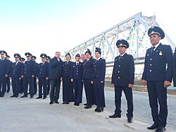
Türkmenabat is connected to Ashgabat, the capital, and Türkmenbaşy, a port city, by the M37 highway. In 2017, two new bridges were opened over the Amu Darya River. One is for trains and the other for cars. These new bridges replaced older ones.
The city also has a bus terminal. You can catch buses there to travel within the region or to other cities. The bus station can serve 700 passengers every day.
Türkmenabat is also close to the border with Uzbekistan at a place called Farap.
Air Travel
A new building for Turkmenabat International Airport opened in 2018. It's located at the southern edge of the city. The airport can handle 500 passengers every hour. From Türkmenabat, you can fly to and from Ashgabat.
Train Travel
Türkmenabat is connected by train to many other cities in Turkmenistan. These include Ashgabat, Mary, Kerki, and Gazojak. A train line from Turkmenabat to Kerki, which is 203 kilometers long, opened in 1999.
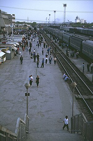
The main train station is in the center of Türkmenabat. It has a two-story building and other buildings for tickets and operations.
Roads
Türkmenabat is linked to Aşgabat, Mary, and Tejen by Turkmenistan's 600-kilometer highway network. This network also connects to neighboring countries.
Staying Connected
You can use 2G, 3G, and LTE mobile networks in Türkmenabat. The most common ways to get internet are through cable networks and ADSL from Turkmentelecom. There are also 9 post office branches in the city.
Culture and Fun
Tasinlikler meýdançasy is a park where people celebrate national holidays.
Türkmenabat is famous for its bazaars, which are like big markets. The largest one is called "World Bazaar" (Dünýa bazar). Other popular bazaars are Gök bazar (Green Bazaar) and Merkezi bazar (Central Bazaar). People from all over the country come to Türkmenabat to buy goods. You can find local items, as well as things from China, Turkey, Uzbekistan, and Russia. The World Bazaar has many different sections, like jewelry, home appliances, clothes, food, and even cars.
Zaton is an artificial beach about 5 kilometers (3 miles) from the city center. It's a popular place for people to relax and have fun, especially during the summer.
Learning in Türkmenabat
Türkmenabat has a state-owned university called Seýitnazar Seýdi adyndaky Türkmen Döwlet Mugallymçylyk Instituty, which focuses on teaching. There is also a medical college, public schools, and special schools for art and sports.
City Partnerships
Türkmenabat has special partnerships with cities in other countries. These are called "sister cities."
See also
 In Spanish: Türkmenabat para niños
 | Emma Amos |
 | Edward Mitchell Bannister |
 | Larry D. Alexander |
 | Ernie Barnes |


