
Ashgabat facts for kids
Quick facts for kids
Ashgabat
Aşgabat
|
|||
|---|---|---|---|
 .jpg) .jpg)   .jpg) Neutrality Road, Gypjak Mosque, Abadanchylyk Square, Independence Park, Suburbs, Urban highways
|
|||
|
|||

Ashgabat
Location in Turkmenistan
|
|||
| Country | |||
| Founded | 1881 | ||
| Government | |||
| • Type | Presidential | ||
| Area | |||
| • Total | 470 km2 (180 sq mi) | ||
| Elevation | 273 m (896 ft) | ||
| Population
(2022 census)
|
|||
| • Total | 1,030,063 | ||
| • Density | 2,192/km2 (5,680/sq mi) | ||
| Time zone | UTC+05:00 (Turkmenistan Time) | ||
| • Summer (DST) | (Not Observed) | ||
| Postal code |
744000–744040
|
||
| Area code(s) | (+993) 12 | ||
| Vehicle registration | AG | ||
.svg)

Ashgabat (in Turkmen: Aşgabat) is the capital and largest city of Turkmenistan. It is located in Central Asia. The city sits between the Karakum Desert and the Kopetdag mountains. It is about 50 kilometers (30 miles) from the Iran-Turkmenistan border. In 2022, its population was over 1 million people.
The city started as a tribal village in 1881. It became the capital of the Turkmen Soviet Socialist Republic in 1924. Back then, it was called Poltoratsk. A huge earthquake in 1948 destroyed most of the city. Since then, it has been rebuilt. Many new buildings are covered in expensive white marble. The Karakum Canal, built during the Soviet era, flows through the city. It carries water from the Amu Darya river. Since 2019, Ashgabat has been known as one of the most expensive cities globally. This is due to rising prices and import issues in Turkmenistan.
Contents
- What Does Ashgabat Mean?
- Where is Ashgabat Located?
- Ashgabat's History
- City Districts
- Who Lives in Ashgabat?
- Ashgabat's Buildings and Art
- Ashgabat's Economy
- Getting Around Ashgabat
- Communication in Ashgabat
- Learning and Education
- Culture and Arts
- Sports in Ashgabat
- International Connections
- Images for kids
- See also
What Does Ashgabat Mean?
.jpg)
The city is called Aşgabat in Turkmen. In Persian, it is عشقآباد (Ešqābād). Before 1991, it was often spelled Ashkhabad in English. This spelling came from the Russian version.
The name literally means "city of love" or "city of devotion" in modern Persian. However, some historians believe the name is much older. Turkmen historian Ovez Gundogdiyev thinks it comes from the Parthian Empire era (3rd century BC). He suggests it is named after Arsaces I of Parthia, who founded the Parthian Empire. So, it would mean "the city of Ashk/Arsaces".
Where is Ashgabat Located?
Ashgabat is about 50 kilometers (30 miles) from the border with Iran. It is on a plain that often has earthquakes. This plain is at the foot of the Kopet Dag mountains to the south. To the north is the Karakum Desert. The city is surrounded by, but not part of, Ahal Province.
The highest point in the city is a 401-meter (1,316 ft) sandhill where the Yyldyz Hotel stands. Most of the city is between 200 and 255 meters (656 and 837 ft) above sea level. The Karakum Canal also runs through the city.
How Ashgabat Grew Over Time
Early City Layout (1881-1929)
Before 1881, most buildings were made of adobe (mud bricks). They were only one story high because of earthquake risks. City planning started after the Russian forces took control. Streets were laid out in a simple, straight pattern. An old description called Ashgabat "a little tidy town" with "clay houses" and "fruit gardens."
The fortress was the main part of the city for officials. Houses there were strong and thick-walled. Near the train station lived railway workers. Their houses were smaller and closer together. Later, a third area grew for merchants, with a marketplace.
City Changes (1930-1948)
In 1930, asphalt was first used to pave Ashgabat's streets. The city also got more water from nearby springs. The first big plan for Ashgabat was made between 1935 and 1937. It aimed to expand the city to the west. Before the 1948 earthquake, Ashgabat had almost no tall buildings. Even two-story buildings stood out.
After the 1948 Earthquake

The 1948 earthquake destroyed almost all buildings in Ashgabat. Most were made of adobe or brick. Only a few strong buildings, like a grain elevator and a church, survived. A new plan was quickly made in 1949. The city was rebuilt with a style called "Brutalist," common in the Soviet Union. This style used lots of concrete and had a simple, strong look.
The city's main street, Magtymguly Avenue, had many two-story buildings. The rebuilding kept the old street layout because changing it would have been too expensive. Ashgabat was seen as a "typically drab provincial Soviet city."
Modern Expansion (1960s Onwards)
In the mid-1960s, a new plan looked at Ashgabat's growth until the year 2000. The city started expanding to the south and west. This led to the first four-story apartment buildings. Some nearby farms were also turned into neighborhoods.
Since 1991, after Turkmenistan became independent, Ashgabat has grown a lot. In 2013, the city added parts of nearby areas, including the city of Abadan. This made Ashgabat much larger. In 2018, more land was added to the north, including a reservoir.
The government plans to build "Ashgabat-City" in the north. This new area will have over 200 buildings, some as tall as 35 stories. It will house more than 107,000 people.
Ashgabat's Climate
| Weather chart for Ashgabat | |||||||||||||||||||||||||||||||||||||||||||||||
|---|---|---|---|---|---|---|---|---|---|---|---|---|---|---|---|---|---|---|---|---|---|---|---|---|---|---|---|---|---|---|---|---|---|---|---|---|---|---|---|---|---|---|---|---|---|---|---|
| J | F | M | A | M | J | J | A | S | O | N | D | ||||||||||||||||||||||||||||||||||||
|
20
9
-0
|
24
11
1
|
41
17
6
|
32
24
12
|
21
30
17
|
6
36
22
|
3
38
24
|
2
37
22
|
3
32
16
|
10
24
10
|
19
17
5
|
20
10
1
|
||||||||||||||||||||||||||||||||||||
| temperatures in °C precipitation totals in mm source: pogoda.ru.net' |
|||||||||||||||||||||||||||||||||||||||||||||||
|
Imperial conversion
|
|||||||||||||||||||||||||||||||||||||||||||||||
Ashgabat has a "cold desert climate." This means it has very hot, dry summers and cool, short, somewhat wet winters. The Kopet Dag mountains are to the south, and the Kara-Kum desert is to the north.
In July, the average high temperature is 38.3°C (100.9°F). Summer nights are warm, with an average low of 23.8°C (74.8°F). In January, the average high is 8.6°C (47.5°F), and the average low is -0.4°C (31.3°F).
The highest temperature ever recorded was 47.2°C (117.0°F) in June 2015. The lowest was -24.1°C (-11.4°F) in January 1969. Snow does not fall often. The city gets only about 201 mm (7.9 inches) of rain each year. March and April are the wettest months.
| Climate data for Ashgabat (1991–2020, extremes 1893–present) | |||||||||||||
|---|---|---|---|---|---|---|---|---|---|---|---|---|---|
| Month | Jan | Feb | Mar | Apr | May | Jun | Jul | Aug | Sep | Oct | Nov | Dec | Year |
| Record high °C (°F) | 27.8 (82.0) |
32.6 (90.7) |
38.6 (101.5) |
39.6 (103.3) |
45.6 (114.1) |
47.2 (117.0) |
46.8 (116.2) |
45.7 (114.3) |
45.4 (113.7) |
40.1 (104.2) |
35.0 (95.0) |
33.1 (91.6) |
47.2 (117.0) |
| Mean daily maximum °C (°F) | 9.0 (48.2) |
11.1 (52.0) |
17.0 (62.6) |
23.9 (75.0) |
30.5 (86.9) |
36.2 (97.2) |
38.4 (101.1) |
37.2 (99.0) |
31.8 (89.2) |
24.4 (75.9) |
15.7 (60.3) |
9.8 (49.6) |
23.8 (74.8) |
| Daily mean °C (°F) | 3.9 (39.0) |
5.7 (42.3) |
11.1 (52.0) |
17.6 (63.7) |
24.1 (75.4) |
29.6 (85.3) |
31.7 (89.1) |
30.0 (86.0) |
24.3 (75.7) |
17.1 (62.8) |
9.7 (49.5) |
5.0 (41.0) |
17.5 (63.5) |
| Mean daily minimum °C (°F) | −0.1 (31.8) |
1.3 (34.3) |
6.0 (42.8) |
11.8 (53.2) |
17.5 (63.5) |
22.3 (72.1) |
24.5 (76.1) |
22.4 (72.3) |
17.1 (62.8) |
10.8 (51.4) |
5.0 (41.0) |
1.1 (34.0) |
11.6 (52.9) |
| Record low °C (°F) | −24.1 (−11.4) |
−20.8 (−5.4) |
−13.3 (8.1) |
−0.8 (30.6) |
1.3 (34.3) |
9.2 (48.6) |
13.8 (56.8) |
9.5 (49.1) |
2.0 (35.6) |
−5.0 (23.0) |
−13.1 (8.4) |
−18.1 (−0.6) |
−24.1 (−11.4) |
| Average precipitation mm (inches) | 21 (0.8) |
33 (1.3) |
42 (1.7) |
33 (1.3) |
23 (0.9) |
8 (0.3) |
3 (0.1) |
2 (0.1) |
3 (0.1) |
12 (0.5) |
23 (0.9) |
18 (0.7) |
221 (8.7) |
| Average rainy days | 9 | 9 | 13 | 12 | 10 | 5 | 3 | 2 | 3 | 6 | 8 | 10 | 90 |
| Average snowy days | 5 | 5 | 1 | 0.03 | 0 | 0 | 0 | 0 | 0 | 0.1 | 1 | 3 | 15 |
| Average relative humidity (%) | 78 | 72 | 66 | 58 | 47 | 35 | 34 | 34 | 40 | 54 | 68 | 77 | 55 |
| Mean monthly sunshine hours | 112.7 | 119.4 | 146.2 | 194.4 | 275.1 | 335.5 | 353.8 | 348.1 | 289.2 | 216.8 | 157.2 | 104.4 | 2,652.8 |
| Source 1: Pogoda.ru.net | |||||||||||||
| Source 2: NOAA (Sunshine hours 1961–1990) | |||||||||||||
Ashgabat's History
Ashgabat grew on the ruins of an old Silk Road city called Konjikala. This city was first mentioned around 1st-2nd century BC for making wine. An earthquake destroyed it in the 1st century BC. Konjikala was rebuilt because it was in a good spot on the Silk Road. It thrived until the Mongols destroyed it in the 13th century. After that, it was a small village until the Russians arrived in the 19th century.
In 1881, Russian forces defeated the Teke army. Persia then gave Ashgabat to the Russian Empire.
Russian Empire Era
The city was officially founded on January 18, 1881. It was a fortified military base. Russian engineers planned the settlement near the village of Askhabad. The fortress was on a 12-meter (39 ft) high hill.
Russia developed the area because it was close to the border of British-controlled Persia. A road was built to Iran in 1882, which increased trade. The Trans-Caspian railway reached Ashgabat in 1885. The population grew quickly, from 2,500 in 1881 to over 19,000 by 1897. Many people from Persia and Armenia settled there.
The city was seen as a nice place with European-style buildings and shops. In 1908, the first Bahá'í House of Worship was built in Ashgabat. It was badly damaged in the 1948 earthquake and later taken down in 1963.
Soviet Period
Soviet rule began in Ashgabat in December 1917. In 1919, the city was renamed Poltoratsk after a local revolutionary. When the Turkmen SSR was created in 1924, Poltoratsk became its capital. The original name, "Ashkhabad," was brought back in 1927. Street names were changed to honor Communist figures.
During World War II, Ashgabat became a safe place for many people and institutions. About 8,000 refugees stayed in private homes. The city grew fast and became more industrial. However, a huge earthquake on October 6, 1948, caused severe damage. It killed a large part of the city's population.
Independence Era

After Turkmenistan became independent in 1991, street names were changed again. Many were named after Turkmen scholars, poets, and national heroes. In 2013, Ashgabat was listed in the Guinness Book of Records. It had the most white marble buildings in the world.
The city has seen many new building projects. For example, the "11th Line" and "12th Line" projects added many high-rise apartment buildings, schools, and shopping centers. Before the 2017 Asian Indoor and Martial Arts Games, the city spent a lot of money on new homes.
New residential areas like Gurtly and Choganly were built. In 2021, plans for the "17th Line" were announced. This will be a resort complex around Golden Lake. The biggest current project is "Ashgabat-City." It will have over 200 buildings, including some as tall as 35 stories.
Ashgabat's key moments:
- 1882–1918 – Main city of Russia's Transcaspian Region.
- 1918–1925 – Main city of the Turkmen Oblast.
- Since February 1925 – Capital of the Turkmen Soviet Socialist Republic.
- Since October 1991 – Capital of independent Turkmenistan.
City Districts
Boroughs of Ashgabat

As of January 5, 2018, Ashgabat has four main boroughs (uly etraplar). Each borough has a mayor chosen by the president.
- Bagtyýarlyk etraby
- Berkararlyk etraby
- Büzmeýin etraby
- Köpetdag etraby
Some boroughs were combined or renamed over time. For example, Abadan and Ruhabat boroughs were merged into others. In 2020, there were plans to create a fifth borough called Altyn etraby. This would be around the new resort area at "Golden Lake."
Microdistricts
Ashgabat's boroughs are divided into smaller areas called microdistricts (etrapçalar). These are used for managing services like utilities and public housing. They do not have their own governments.
Some of Ashgabat's microdistricts include:
- 1 through 11 Etrapça
- 30 Etrapça
- Howdan A, B, W
- Parahat 1 through 8
Who Lives in Ashgabat?
In 1871, there were many Ahal Teke Turkmen living in the area. After 1881, the population of Ashgabat was mostly ethnic Russians. About 20% were migrants from the Caucasus, mainly Armenians. Some sources say there were no Turkmen residents in the city itself before the revolution. They lived in nearby villages.
This changed in the 1920s under Soviet rule. By 1926, Russians made up 52.4% of Ashkhabad's population. Armenians were 13.53%, and Persians were 4.3%. By 1939, the city had 126,500 residents.
According to 2012 estimates, Turkmens make up 78.5% of the city's population. Russians are 10%, followed by Turks (1.1%), Uzbeks (1.1%), and Azeris (1%).
Ashgabat's Buildings and Art
Modern Architecture (After 1991)
After Turkmenistan became independent in 1991, new buildings were designed with a mix of styles. They often combined Persian-style domes with Greek and Roman elements like pillars.
Later, domes became less common for buildings other than mosques. Public buildings started to look more modern. They often had designs that showed what the building was for. For example, the Ministry of Foreign Affairs building has a globe on top. The Development Bank building has a giant coin. The Ashgabat International Airport terminal is shaped like a falcon.
Most new buildings since 1991 are covered in white marble. Another common design is the eight-pointed star of Oguz Han. The largest one is on the television tower and is in the Guinness World Records.
Monuments and Statues
Ashgabat has many sculptures honoring Turkmen and Islamic poets and heroes. Some statues, like those of Lenin and Alexander Pushkin, are from the Soviet era. Many new sculptures have been added since independence. You can find busts and statues in Ylham (Inspiration) Park.
There are also monuments to Turkmenistan's government features. These include monuments to neutrality, the constitution, and independence. A special monument honors former President Saparmurat Niyazov's book, Ruhnama.
The memorial complex in Bekrewe has a statue of a bull with the Earth on its horns. This symbolizes the 1948 earthquake. There is also a statue of two Turkmen warriors guarding a widow.
Many traffic circles have abstract monuments. Recent additions include the Bicycle Monument (2020) and the Turkmen Alabay monument (2020).
First Bahá'í Temple in the World

When Ashgabat was under Russian rule, the number of Bahá'ís grew to over 1,000. They built their own schools, medical places, and a cemetery. In 1908, the Bahá'í community finished building the first Bahá'í House of Worship. This was a place where people of all religions could worship God.
The House of Worship was surrounded by gardens. It had a school, a hostel for visitors, a small hospital, and a building for groundskeepers. The Bahá'ís gave up these properties in 1928 due to Soviet rules. The building was an art gallery for a while. It was badly damaged in the 1948 earthquake and taken down in 1963.
Other Famous Buildings
- The Arch of Neutrality was moved to the south of the capital.
- Turkmenistan Tower is the tallest building in the country at 211 meters (692 ft). It opened in 2011.
- The Alem Cultural and Entertainment Center has the world's tallest Ferris wheel inside a building.
- The Ashgabat Flagpole is the fifth tallest free-standing flagpole in the world.
- The Ashgabat Fountain has the most fountain pools in a public place.
Palaces
- Oguzhan Presidential Palace: The official home of the president.
- Ruhyýet Palace: Used for official state events and meetings.
- Wedding Palace: A building for civil weddings.
Parks and Public Spaces
Ashgabat has many parks and open areas. They were mostly created after independence and are well-kept. Some important parks include:
- The Botanical Garden
- Güneş Park
- Turkmen-Turkish Friendship Park
- Independence Park
The oldest city park, Ashgabat Park, was founded in 1887. The Inspiration Alley is an art-park complex. The World of Turkmenbashi Tales amusement park is like a local Disneyland.
The Ashgabat Botanical Garden started in 1929. It is the oldest botanical garden in Central Asia. It has over 500 different types of plants from around the world.
Halk Hakydasy Memorial Complex
Halk Hakydasy Memorial Complex opened in 2014. It honors those who died in the Battle of Geok Tepe in 1881, during World War II, and in the 1948 Ashgabat earthquake. It is located in the southwestern part of the city.
Mosques
.jpg)
Major mosques in Ashgabat include:
- Türkmenbaşy Ruhy Mosque
- Ärtogrul Gazy Mosque: A gift from Turkey, it looks like the Blue Mosque in Istanbul.
- Hezreti Osman Mosque
- Hezreti Omar Mosque
- Azadi Mosque
- Shehitler Mosque
- Iranian Mosque
Churches
Ashgabat has five Christian churches that are currently open. Four are Russian Orthodox:
- Saint Alexander Nevsky Church
- Temple of Saint Nicholas the Miracle-Worker
- Temple of the Resurrection of Jesus Christ
- Temple of the Holy Equals to Apostles Cyril and Methodius
The Roman Catholic Chapel of the Transfiguration is also open.
Ashgabat's Economy
The main industries in Ashgabat are cotton textiles and metal working. It is an important stop on the Trans-Caspian railway. Many jobs in Ashgabat come from government offices and ministries. There are also many foreign diplomats working in embassies.
Ashgabat is part of the Ashgabat agreement. This agreement helps transport goods between Central Asia and the Persian Gulf. In 2019 and 2020, Ashgabat was ranked as one of the most expensive cities in the world for foreigners. This is due to high inflation and rising import costs.
Industries
Between 1881 and 1921, Ashgabat had little industry. By 1915, there were about 68 small businesses. Most of these were handicrafts. The railway depot employed about half of the workers. Other jobs included cotton processing, flour milling, and making leather, bricks, glass, and iron.
In 1921, Soviet leaders built a new glass plant and a wine factory. More factories were added later, making things like silk, cotton, shoes, and canned meat. By 1948, Ashgabat had about 20 large factories. They produced fabrics, glass, footwear, and more.
Today, Ashgabat and its suburbs have over 43 large and 128 medium-sized industrial businesses. There are also more than 1,700 small industrial places. Important ones include Ashneftemash, Turkmenkabel, and Turkmenbashy Textile Complex.
Electricity Production
The Büzmeýin State Power Plant, built in 1957, was Turkmenistan's first large power plant. The Ashgabat State Power Plant opened in 2006. Ashgabat also gets power from the Ahal State Power Plant, located outside the city.
Shopping in Ashgabat


The Altyn Asyr Bazaar, also called "Tolkuchka," sells traditional fabrics, hand-woven carpets, and even livestock. Modern shopping centers are mostly in the city center. These include the Berkarar Mall, Ashgabat Shopping and Entertainment Center, and Gül Zemin.
Local people often shop at traditional bazaars. These include the Gülistan (Russian) Bazaar, Teke Bazaar, and Paytagt (Mir) Bazaar.
Getting Around Ashgabat
.jpg)
.jpg)
The city has the Ashgabat International Airport. It cost $2.3 billion to expand and can handle 14 million passengers a year. Turkmenistan Airlines has its main office there. Since March 2020, all international flights to Turkmenistan are sent to Turkmenabat International Airport to prevent the spread of coronavirus.
The Ashgabat Cable Car opened in 2006. It connects the city to the Kopetdag mountains. The Ashgabat Monorail started in 2016. It is the first monorail in Central Asia. It runs in a loop around the Olympic Village.
In January 2018, it was reported that black cars were taken away in Ashgabat. This was because President Gurbanguly Berdimuhamedov believed black cars bring bad luck.
A Ukrainian company has suggested building a subway line. It would connect the new Ashgabat-City area to downtown.
Roads and Highways
Ashgabat is connected to other cities like Tejen and Mary by a 600 km (370 mi) autobahn network.
Train Travel

Ashgabat has one main railway station. It was restored in 2009. The Trans-Caspian Railway runs through Ashgabat. There is also a train line to the north, the Trans-Karakum Railway.
Train routes from Ashgabat include:
- Ashgabat to Balkanabat
- Ashgabat to Türkmenbaşy
- Ashgabat to Dashoguz
- Ashgabat to Sarahs
- Ashgabat to Serhetabat
- Ashgabat to Amyderýa
City Buses and Trolleybuses
.jpg)

Public transport in Ashgabat mainly uses buses. Over 100 bus lines cover more than 2,230 kilometers (1,386 miles). The city uses buses from Iran Khodro and Hyundai. Bus stops have timetables and route maps.
Since November 2017, an electronic payment system for public transport is used. Passengers can pay with an electronic transport card. The fare for a bus ride is 50 Turkmen tenge.
The new International Passenger Bus Terminal of Ashgabat opened in 2014. It offers bus service to other cities in Turkmenistan.
From 1964 to 2011, Ashgabat also had a trolleybus system.
Taxis
Taxis in Ashgabat are usually white or yellow. They have a green "TAXI" sign on the roof. Most taxis are Toyota Corolla, JAC J7, or Hyundai Elantra cars. They are available day and night. You can also call a taxi using mobile apps or by waving your hand on the street.
Communication in Ashgabat
As of 2021, Ashgabat has two mobile phone companies:
- Altyn Asyr: A state-owned company that started in 2004. It launched 3G in 2010 and 4G in 2013.
- Ashgabat City Telephone Network: Provides CDMA communication services.
Turkmentelecom provides internet services. Turkmenpochta is the official postal service. It has 38 post offices in the city.
Media
Newspapers published in Ashgabat include Türkmenistan and Neytralny Turkmenistan.

TV Channels
The main offices of 7 TV channels are in Ashgabat: Altyn Asyr, Yashlyk, Miras, Turkmenistan Sport, Turkmen Owazy, Ashgabat, and Turkmenistan TV. Ashgabat TV is the main city channel. It covers social, cultural, and economic news.
Subscribers to the Ashgabat City Telephone Network can watch about 136 international TV channels. Many residents also watch TV using satellite dishes.
Radio Stations
As of 2008, Ashgabat has 4 FM radio stations: Owaz, Char Tarapdan, Miras, and Watan. You can also listen to these stations online.
Learning and Education


Ashgabat is a very important center for education in Turkmenistan. It has several universities and colleges. Turkmen State University was founded in 1950. The Turkmen State Medical University is also in Ashgabat.
Other important schools include:
- Turkmen State Institute of Economics and Management
- Turkmen State Institute of Architecture and Construction
- Turkmen Agricultural University
- The National Institute of Sports and Tourism of Turkmenistan
In 2016, the Oguz Khan University of Engineering Technologies opened. It teaches in English and Japanese. The International University of Humanities and Development also teaches in English. The Institute of International Relations trains people for foreign affairs.
Ashgabat also has five military academies. In 2020, the Military Institute started accepting women.
There are four international secondary schools in Ashgabat. These include the Russian-medium A.S. Pushkin Russo-Turkmen School and the English-medium Ashgabat International School.
Before Soviet rule, Ashgabat had only 11 schools and no research centers. By 1948, it had three universities, 20 technical schools, and 60 libraries.
The Turkmen Academy of Sciences was founded in 1951. It has 26 research institutes, including the unique Desert Institute. It is the only place in Turkmenistan that can give postgraduate degrees.
Culture and Arts
Ashgabat is the cultural center of Turkmenistan. It has many theaters, museums, galleries, concert halls, and cinemas.
Museums and Galleries

The Trans-Caspian Regional Museum opened in 1899. The National Museum of Turkmenistan opened in 1998. Its main goal is to show Turkmenistan's history using old collections. Since 2013, it is called The State Museum of the State Cultural Center of Turkmenistan.
Other museums include the Turkmen Fine Arts Museum and Turkmen Carpet Museum. These museums have amazing collections of woven carpets. There is also a Turkmen history museum and the Ashgabat National Museum of History. These display items from the Parthian and Persian civilizations.
Performing Arts
Ashgabat's main theaters are:
- Alp Arslan National Drama Theatre
- Magtymguly National Musical and Drama Theatre
- Main Drama Theatre named by Saparmurat Turkmenbashi
- Mollanepes Students Theatre
- Mukams Palace
- Pushkin State Russian Drama Theatre
- Theatre "Art Ist"
- Turkmen State Puppet Theatere
- Turkmen State Circus
Cinemas
Ashgabat has five cinemas. In 2011, Aşgabat Cinema opened. It was the first 3-D cinema in Turkmenistan. Other cinemas are in the Berkarar Mall and the Gül zemin Mall.
Sports in Ashgabat

The main sports places in Ashgabat are the Olympic Stadium, Ashgabat Stadium, and the National Olympic ice rink. There is also a sports complex for winter sports and the Ashgabat Watersports Complex.
Ashgabat hosted the 2017 Asian Indoor and Martial Arts Games. An Olympic Village was built for this event between 2010 and 2017. It cost $5 billion.
In October 2017, an 18-hole golf course opened in Ashgabat. It has 82 sand traps and covers 70 hectares (173 acres).
Ashgabat also hosted the 2018 World Weightlifting Championships. The city's professional football clubs are Altyn Asyr FK, FC Aşgabat, and FK Köpetdag Aşgabat. They play in Turkmenistan's top league.
Inha Babakova, a world high jump champion, was born in Ashgabat. Weightlifter Polina Guryeva, also born in Ashgabat, won Turkmenistan's first Olympic medal in 2020. She won a silver medal in women's 59 kg weightlifting.

International Connections
Embassies and Missions
Ashgabat is home to 32 foreign embassies. It also hosts the International Fund for Saving the Aral Sea and the United Nations Regional Centre for Preventive Diplomacy in Central Asia (UNRCCA).
Sister Cities
Ashgabat is connected with these cities around the world:
Partner Cities
Ashgabat also works closely with:
 Moscow, Russia (1996)
- Chelyabinsk Oblast, Russia (1997)
 Yerevan, Armenia (2014)
 Tokyo, Japan (2014)
Images for kids
-
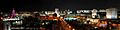
Panorama of Ashgabat at night
See also
 In Spanish: Asjabad para niños
