Tajuña facts for kids
Quick facts for kids Tajuña |
|
|---|---|

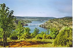
Tajera reservoir
|
|
| Country | c |
| State | Guadalajara, Madrid |
| Region | Castile-La Mancha, Madrid |
| Physical characteristics | |
| Main source | Fuente del Carro Clares, Guadalajara 1,244 m (4,081 ft) 41°1′48″N 2°8′24″W / 41.03000°N 2.14000°W |
| River mouth | Titulcia, Madrid 509 m (1,670 ft) 40°7′43″N 3°34′57″W / 40.12861°N 3.58250°W |
| Length | 225 km (140 mi) |
| Depth |
|
| Basin features | |
| Progression | Jarama→ Tagus→ Atlantic Ocean |
| River system | Jarama |
| Basin size | 2,608 km2 (1,007 sq mi) |
| Tributaries |
|
| Tagus Basin | |
The Tajuña is a river in central Spain. Its name comes from the Latin word Tagonius. The Tajuña flows through two important areas: the province of Guadalajara and the Community of Madrid.
This river is a "tributary" of the Jarama river. This means the Tajuña flows into the Jarama. The Jarama then flows into an even bigger river called the Tagus. The Tajuña starts high up in the Sierra de Solorio mountains. It begins near a town called Maranchón in Guadalajara, at a spot known as Fuente del Carro, close to the village of Clares.
Contents
The Tajuña River's Journey
The Tajuña river begins its journey in high, open lands called moorlands. As it flows, it carves deep valleys through ancient rocks. These rocks are mostly limestone, which is a type of rock formed from old sea creatures.
Where the River Flows
Along its path, the Tajuña river has one main reservoir called La Tajera. A reservoir is like a big lake built to store water. This reservoir is near the town of Cifuentes.
The river then passes through many towns and villages. In Guadalajara province, it flows near Luzón, Anguita, Luzaga, Cortes de Tajuña, Brihuega, and Renera. After this, the Tajuña enters the Community of Madrid.
In Madrid, the river continues its journey. It goes close to Ambite, Orusco, Carabaña, Tielmes, Perales de Tajuña, and Morata de Tajuña. Finally, the Tajuña river joins the Jarama river near the town of Titulcia.
Climate Around the Tajuña River
The weather in the area where the Tajuña river flows is called Mediterranean. This means it usually has hot, dry summers and mild, wet winters. As the river gets closer to the Jarama, the climate becomes drier. Most of the rain falls in autumn and winter.
How the Tajuña River Gets Its Water
The Tajuña is an "internal river." This means its smaller rivers, called tributaries, often only have water during certain times of the year, especially in spring.
The Tajuña gets its water from two main sources:
- Springs: These are places where water naturally flows out of the ground.
- Aquifer: A large underground area of rock or soil that holds water. The Tajuña gets water from the Calizas del Páramo de la Alcarria aquifer. This aquifer is very big, covering about 1,800 square kilometers (about 695 square miles). The water in this aquifer is usually found about 30 to 40 meters (around 100 to 130 feet) deep.
See also
 In Spanish: Río Tajuña para niños
 | Kyle Baker |
 | Joseph Yoakum |
 | Laura Wheeler Waring |
 | Henry Ossawa Tanner |

