
Sierra de Solorio facts for kids
Quick facts for kids Solorio Range |
|
|---|---|

Winter landscape of the range in Maranchón
|
|
| Highest point | |
| Peak | Alto de San Sebastián |
| Elevation | 1,366 m (4,482 ft) |
| Dimensions | |
| Length | 54 km (34 mi) ENE/WSW |
| Width | 18 km (11 mi) NNW/SSE |
| Geography | |

Solorio Range
Location in Spain
|
|
| Location | Zaragoza, Aragon Guadalajara, Castile-La Mancha |
| Parent range | Iberian System, western zone |
| Geology | |
| Orogeny | Alpine orogeny |
| Age of rock | Mesozoic |
| Type of rock | Conglomerate, clay |
| Climbing | |
| Easiest route | From the towns of Maranchón or Luzón |
The Solorio Range (called Sierra de Solorio in Spanish) is a cool mountain range in the western part of the Iberian System in Spain. It stretches across three different regions: Aragon, Castile-La Mancha, and Castile and León. Imagine a long line of mountains that separates different parts of Spain!
About the Solorio Mountains
These mountains generally run from east to west. To the north, you'll find the Jalón River. To the south, there's the Sierra de Selas and the Parameras de Molina. On the eastern side, the Piedra River and the La Tranquera Dam mark the end. From there, the mountains go west until they reach Sierra Ministra.
Not many people live in this area. The villages are small and far apart, so it's a very quiet place!
The Solorio Range is super important because it acts like a giant wall that divides where water flows. Rivers like the Tajuña (which flows into the Tagus River) and the Mesa River (which joins the Piedra River, part of the Ebro system) start here. The Tajuña flows towards the Atlantic Ocean, while the Mesa flows towards the Mediterranean Sea.
This mountain range is also home to the biggest Spanish Juniper forest in all of Europe! You can also find the Common Juniper growing here.
Mountain Peaks
The peaks in the Sierra de Solorio aren't super tall or pointy. Their "prominence" (how much they stick up from the land around them) is usually less than 300 meters.
The highest point is called Alto de San Sebastián, which is 1,366 meters (about 4,482 feet) high. Other important peaks include:
- Veracruz (1,355 m), located south of Luzón
- Las Papas (1,351 m), found between Judes and Maranchón
- Alto de la Calera (1,308 m), between Iruecha and Codes
- Alto de Judes (1,293 m), east of Judes
- Sima de Calmarza (1,039 m), east of Calmarza
- Cabeza del Águila (1,022 m), north of Calmarza
- Loma del Camarero (949 m), north of Jaraba
There's also a mountain pass near the town of Maranchón, which is like a lower path through the mountains.
Cool Features
-
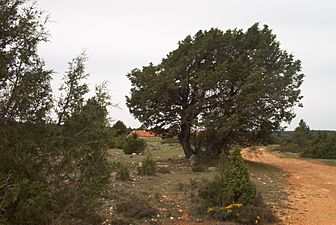
Spanish Juniper trees in the range
-
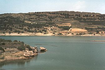
View of the eastern end of the range at La Tranquera Dam
-
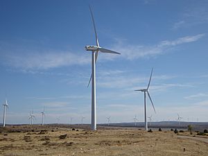
Wind farm on top of the ridge near Maranchón


See also
 In Spanish: Sierra de Solorio para niños
- Iberian System
- Mountains of Aragon
