
Talbotton, Georgia facts for kids
Quick facts for kids
Talbotton, Georgia
|
|
|---|---|

Confederate Monument in Talbotton, 2012
|
|

Location in Talbot County and the state of Georgia
|
|
| Country | United States |
| State | Georgia |
| County | Talbot |
| Area | |
| • Total | 3.13 sq mi (8.09 km2) |
| • Land | 3.10 sq mi (8.04 km2) |
| • Water | 0.02 sq mi (0.05 km2) |
| Elevation | 732 ft (223 m) |
| Population
(2020)
|
|
| • Total | 742 |
| • Density | 238.97/sq mi (92.27/km2) |
| Time zone | UTC−5 (Eastern (EST)) |
| • Summer (DST) | UTC−4 (EDT) |
| ZIP code |
31827
|
| Area code(s) | 706 |
| FIPS code | 13-75244 |
| GNIS feature ID | 0333180 |
Talbotton is a city in Talbot County, Georgia, United States. It is the main town, or county seat, of Talbot County. In 2020, about 742 people lived there.
Contents
History of Talbotton
Talbotton was started in 1828. It became the main town for the new Talbot County. Both the county and the town were named after Governor Matthew Talbot.
A famous family, the Straus family, began their retail business here in the 1800s. Later, in 1896, this family bought R. H. Macy & Co. in New York.
Geography and Location
Talbotton is located at coordinates 32.678170 degrees North and -84.539787 degrees West. The city covers about 3.1 square miles (8.0 square kilometers) of land. Only a tiny part is water.
How to Get Around Talbotton
The city is in the middle of Talbot County. U.S. Route 80 goes through the main part of town. This road leads east about 34 miles (55 km) to Roberta. It also goes southwest about 37 miles (60 km) to Columbus.
Other state roads also pass through Talbotton. Georgia State Route 90 goes southeast about 8 miles (13 km) to Junction City. Georgia State Route 208 goes west about 13 miles (21 km) to Waverly Hall.
Climate and Weather in Talbotton
Talbotton has a humid subtropical climate. This means it has hot, humid summers and mild winters. The hottest temperature ever recorded was 110°F (43°C) on July 19, 1913. The coldest was -6°F (-21°C) on February 13, 1899.
On March 3, 2019, a strong tornado hit the town. It caused a lot of damage to buildings and trees.
| Climate data for Talbotton, 1981-2010 normals, extremes 1893-present | |||||||||||||
|---|---|---|---|---|---|---|---|---|---|---|---|---|---|
| Month | Jan | Feb | Mar | Apr | May | Jun | Jul | Aug | Sep | Oct | Nov | Dec | Year |
| Record high °F (°C) | 82 (28) |
83 (28) |
93 (34) |
96 (36) |
100 (38) |
105 (41) |
110 (43) |
107 (42) |
108 (42) |
100 (38) |
89 (32) |
83 (28) |
110 (43) |
| Mean daily maximum °F (°C) | 55.3 (12.9) |
59.8 (15.4) |
67.2 (19.6) |
73.9 (23.3) |
80.7 (27.1) |
86.6 (30.3) |
89.2 (31.8) |
88.0 (31.1) |
83.2 (28.4) |
74.3 (23.5) |
66.3 (19.1) |
56.7 (13.7) |
73.4 (23.0) |
| Mean daily minimum °F (°C) | 32.1 (0.1) |
35.2 (1.8) |
41.2 (5.1) |
48.4 (9.1) |
56.9 (13.8) |
65.5 (18.6) |
69.0 (20.6) |
68.4 (20.2) |
62.2 (16.8) |
49.9 (9.9) |
40.9 (4.9) |
33.8 (1.0) |
50.3 (10.2) |
| Record low °F (°C) | −5 (−21) |
−6 (−21) |
12 (−11) |
25 (−4) |
33 (1) |
42 (6) |
50 (10) |
50 (10) |
34 (1) |
23 (−5) |
8 (−13) |
1 (−17) |
−6 (−21) |
| Average precipitation inches (mm) | 4.38 (111) |
4.89 (124) |
5.38 (137) |
3.65 (93) |
3.19 (81) |
4.28 (109) |
5.00 (127) |
3.83 (97) |
3.51 (89) |
3.03 (77) |
3.95 (100) |
4.61 (117) |
49.7 (1,262) |
| Average precipitation days (≥ 0.01 in) | 7.6 | 7.5 | 7.4 | 6.3 | 6.8 | 8.3 | 8.6 | 7.5 | 5.7 | 5.5 | 6.1 | 7.4 | 84.7 |
| Source: NOAA | |||||||||||||
People Living in Talbotton
| Historical population | |||
|---|---|---|---|
| Census | Pop. | %± | |
| 1870 | 796 | — | |
| 1880 | 1,008 | 26.6% | |
| 1890 | 1,140 | 13.1% | |
| 1900 | 1,131 | −0.8% | |
| 1910 | 1,081 | −4.4% | |
| 1920 | 1,093 | 1.1% | |
| 1930 | 1,064 | −2.7% | |
| 1940 | 1,060 | −0.4% | |
| 1950 | 1,175 | 10.8% | |
| 1960 | 1,163 | −1.0% | |
| 1970 | 1,045 | −10.1% | |
| 1980 | 1,140 | 9.1% | |
| 1990 | 1,046 | −8.2% | |
| 2000 | 1,019 | −2.6% | |
| 2010 | 970 | −4.8% | |
| 2020 | 742 | −23.5% | |
| U.S. Decennial Census 1850-1870 1870-1880 1890-1910 1920-1930 1940 1950 1960 1970 1980 1990 2000 2010 |
|||
In 2020, the census counted 742 people living in Talbotton. There were 372 households and 222 families.
| Race | Num. | Perc. |
|---|---|---|
| White (non-Hispanic) | 122 | 16.44% |
| Black or African American (non-Hispanic) | 600 | 80.86% |
| Native American | 1 | 0.13% |
| Asian | 2 | 0.27% |
| Other/Mixed | 7 | 0.94% |
| Hispanic or Latino | 10 | 1.35% |
Education in Talbotton
The main office for the Talbot County School District is in Talbotton. The only school building in the entire county is also located here. The district has 48 full-time teachers. They teach over 792 students.
- Central Elementary/High School
Famous People from Talbotton
Many interesting people have connections to Talbotton:
- John W. Bower: He signed the Texas Declaration of Independence. He was also a member of the House of Representatives for the Republic of Texas.
- Charles Henry Jones: A journalist and editor who was born in Talbotton.
- Clarence Jordan: A farmer and scholar of ancient Greek.
- George W. Towns: A U.S. Representative and the 39th Governor of Georgia. He used to live in Talbotton.
- Lady: An American rapper born in Talbotton.
- Elizabeth Evelyn Wright: She founded Voorhees College.
- Isidor Strauss: A U.S. Representative and co-founder of Macy's Department Store. He lived in Talbotton when he was young. He sadly died when the R.M.S. Titanic sank.
Images for kids
-
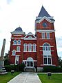
The Talbot County Courthouse was built in 1892. It is known for its Queen Anne style. It was added to the National Register of Historic Places in 1980.
-
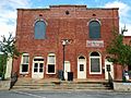
Talbotton City Hall
-

Talbotton Post Office (ZIP code: 31827)
-
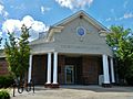
Talbot County Public Library
-
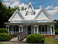
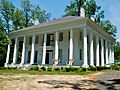
The Newton P. Carreker House was added to the National Register of Historic Places in 1980.
-
The Straus-LeVert Memorial Hall is part of the LeVert Historic District. This district was added to the National Register of Historic Places in 1976.
-
The David Shelton House was added to the National Register of Historic Places in 1980.
-
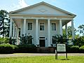
The George W. Towns House was added to the National Register of Historic Places in 1973.
-

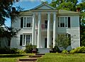
The Weeks-Kimbrough House was added to the National Register of Historic Places in 1979.
-
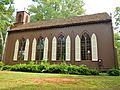
Zion Episcopal Church was started in the 1830s. It has special galleries inside for enslaved people who attended services. The church is still used today and was added to the National Register of Historic Places in 1974.


.JPG)


;_Talbotton,_GA_(NRHP).JPG)
.JPG)
.JPG)
.JPG)
;_Talbotton,_GA.JPG)
See also
 In Spanish: Talbotton para niños
