Taopi, Minnesota facts for kids
Quick facts for kids
Taopi, Minnesota
|
|
|---|---|

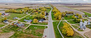
MN-56 runs through Taopi.
|
|

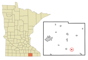
Location in Mower County and the state of Minnesota
|
|
| Country | United States |
| State | Minnesota |
| County | Mower |
| Area | |
| • Total | 0.39 sq mi (1.01 km2) |
| • Land | 0.39 sq mi (1.01 km2) |
| • Water | 0.00 sq mi (0.00 km2) |
| Elevation | 1,342 ft (409 m) |
| Population
(2020)
|
|
| • Total | 61 |
| • Density | 156.01/sq mi (60.24/km2) |
| Time zone | UTC-6 (Central (CST)) |
| • Summer (DST) | UTC-5 (CDT) |
| ZIP code |
55977
|
| Area code(s) | 507 |
| FIPS code | 27-64210 |
| GNIS feature ID | 2396030 |
Taopi (pronounced tay-OH-pee) is a small city in Mower County, Minnesota, United States. In 2020, about 61 people lived there. It is located close to where the Wapsipinicon River begins.
Contents
History of Taopi
How Taopi Got Its Name
The city of Taopi is named after a Native American chief named Taopi. He was a friendly chief who helped settlers after an event known as the New Ulm massacre.
Early Days of the Village
The area was first planned out in 1875 by the Taopi Farming Company. John W. Wood was involved in this planning. The very first piece of land was bought by James Olberg. A man named J. Martz opened a furniture store here before moving it to Le Roy.
The Big Flour Mill
Taopi was once home to a very large steam-powered flour mill. This mill was the biggest in southern Minnesota. It could process a huge amount of wheat, up to 300,000 bushels each year.
Recent Tornado Event
On April 12, 2022, a strong tornado hit Taopi. It was an EF2 tornado, which means it caused significant damage. Luckily, only two minor injuries were reported. This tornado was part of a larger storm system that affected North America.
Geography of Taopi
Where Taopi is Located
Taopi is found in the southern part of Mower County. It is surrounded by Lodi Township. Minnesota State Highway 56 goes right through the city. This highway connects Taopi to other towns.
Nearby Towns and Cities
If you go west on Highway 56 for about 4 miles, you will reach Adams. Going southeast for about 8 miles will take you to Le Roy. Austin is the main city in Mower County, and it's about 21 miles northwest of Taopi.
Rivers and Waterways
The city of Taopi covers about 0.39 square miles (1.01 square kilometers) of land. The North Branch of the Upper Iowa River flows through the eastern part of the city. The source of this river is about 3 miles north of Taopi. Also, the Wapsipinicon River starts less than a mile south of the city.
Population of Taopi
| Historical population | |||
|---|---|---|---|
| Census | Pop. | %± | |
| 1880 | 115 | — | |
| 1900 | 115 | — | |
| 1910 | 140 | 21.7% | |
| 1920 | 153 | 9.3% | |
| 1930 | 102 | −33.3% | |
| 1940 | 151 | 48.0% | |
| 1950 | 118 | −21.9% | |
| 1960 | 92 | −22.0% | |
| 1970 | 59 | −35.9% | |
| 1980 | 96 | 62.7% | |
| 1990 | 83 | −13.5% | |
| 2000 | 93 | 12.0% | |
| 2010 | 58 | −37.6% | |
| 2020 | 61 | 5.2% | |
| U.S. Decennial Census | |||
Population Changes Over Time
The population of Taopi has changed quite a bit over the years. In 1880, there were 115 people living there. The population grew to 153 in 1920, which was its highest point. Since then, the number of people living in Taopi has generally decreased. In 2020, the population was 61.
Life in Taopi in 2010
According to the census from 2010, there were 58 people living in Taopi. These people lived in 24 different homes. Most of these homes (18 of them) were families.
About a third of the homes had children under 18 living there. Most families were married couples living together. The average age of people in Taopi was about 38.5 years old. The population was split evenly between males and females.
See also
 In Spanish: Taopi (Minnesota) para niños
 | Calvin Brent |
 | Walter T. Bailey |
 | Martha Cassell Thompson |
 | Alberta Jeannette Cassell |

