Tarragindi, Queensland facts for kids
Quick facts for kids TarragindiBrisbane, Queensland |
|||||||||||||||
|---|---|---|---|---|---|---|---|---|---|---|---|---|---|---|---|
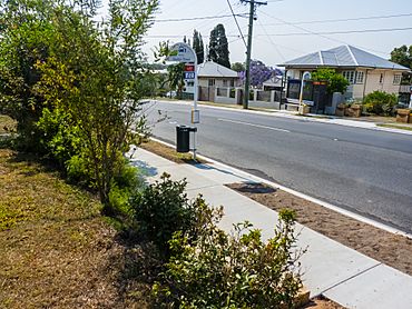
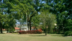
Sexton Street, 2012
|
|||||||||||||||
| Population | 11,035 (2021 census) | ||||||||||||||
| • Density | 2,452/km2 (6,350/sq mi) | ||||||||||||||
| Established | 1857 | ||||||||||||||
| Postcode(s) | 4121 | ||||||||||||||
| Elevation | 58 m (190 ft) | ||||||||||||||
| Area | 4.5 km2 (1.7 sq mi) | ||||||||||||||
| Location | 9 km (6 mi) from Brisbane CBD | ||||||||||||||
| LGA(s) | City of Brisbane | ||||||||||||||
| State electorate(s) | Miller | ||||||||||||||
| Federal Division(s) | Moreton | ||||||||||||||
|
|||||||||||||||
Tarragindi (/tærəɡɪndi/) is a friendly suburb located in the southern part of Brisbane, Queensland, Australia. It's a great place to live, with a mix of homes and green spaces. In 2021, about 11,035 people called Tarragindi home. Local representatives from the Brisbane City Council help look after the area.
Contents
Exploring Tarragindi's Geography
Tarragindi is bordered by some key landmarks. The Southeast Freeway and Toohey Forest help define its edges. On the western side, you'll find Ekibin Road and streets around the Tarragindi Reservoir. Prior Street and Mayfield Road mark the southern boundary.
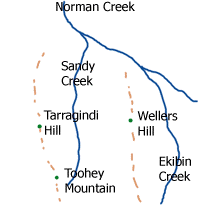
Most of the suburb sits in a valley that runs from north to south. This valley is surrounded by hills. Wellers Hill is the highest point to the east, and Tarragindi Hill is to the west. Sandy Creek starts in Toohey Forest and flows through the main part of the suburb. Water from the eastern side of Wellers Hill flows into Ekibin Creek.
A Look Back at Tarragindi's History
How Tarragindi Got Its Name
The suburb is named after a man called Tarragindi Tasserone. He came from the Loyalty Islands, near New Caledonia, in the late 1800s. Many people from these islands, known as Kanakas, were brought to Queensland to work on sugar cane farms.
Tarragindi Tasserone managed to escape and later worked for Alfred Foote in Ipswich. He then helped clear land for William Grimes on a hill near Sandy Creek. This land was named after him. Tarragindi stayed with the Foote family for over 25 years until he passed away at 63. His grave is in the Ipswich General Cemetery.
The First People of Tarragindi
Before European settlers arrived in the early 1800s, Aboriginal people lived in this area. The Coorparoo group, part of the larger Jagera nation, lived south of the Brisbane River. They had special paths, river crossings, and ceremonies that connected them to other groups.
It's believed a special meeting place called a bora ring was once in Tarragindi. This might have been between what are now Barnehurst and Isabella Streets. The name "Ekibin" for a local creek comes from the Aboriginal word "Yekkabin." This word referred to water plants with edible roots that grew in the creek. These roots were an important food source for the Aboriginal people of the Moreton Bay area.
Early European Settlers
European settlement in Tarragindi began in 1857. George Pratten surveyed the land. An important early landowner was Thomas Blacket Stephens. He later became the Mayor of Brisbane. He set up a wool-cleaning business and a fellmongery (where animal skins are prepared) in the northern part of the suburb. Another early landholder was James Toohey, who used the land for cattle farming.
Tarragindi During World War II
During the Second World War, Tarragindi was home to a large hospital. It was first run by the American Army to help soldiers recovering from stress. Later, British and Australian forces used it. This Ekibin Hospital was located near Sexton Street and Toohey Road. After the war, the land was used to house people who had lost their homes. Today, you can still find some small signs of the hospital, like possible old foundations. Ekibin Memorial Park on Cracknell Road remembers the hospital.
Who Lives in Tarragindi?
Tarragindi is a growing community! Here's a quick look at its population:
- In 2011, there were 9,965 people.
- In 2016, the population grew to 10,779.
- By 2021, Tarragindi had 11,035 residents.
The average age of people in Tarragindi is 37 years old. Most people (about 80%) were born in Australia. Other countries of birth include England, New Zealand, Japan, India, and China. English is the main language spoken at home. Other languages you might hear include Japanese, Mandarin, Greek, Vietnamese, and Spanish.
Schools in Tarragindi
Tarragindi has two great primary schools for kids to learn and grow.
Wellers Hill State School
Wellers Hill State School is located where Weller and Toohey Roads meet. This school is well-known for its excellent music program. The school's motto is 'Strive to Succeed,' which encourages students and teachers to do their best.
The school has four sports houses, named after Australian animals:
- Platypus (yellow)
- Emu (blue)
- Kangaroo (red)
- Koala (green)
In 2014, the school started a Japanese Bilingual program. They also have a student exchange program with a sister school in Yasugi, Japan.
St. Elizabeth's Catholic Primary School
St. Elizabeth's Catholic Primary School is found at 55 Effingham Street, near Cracknell Road. This school also has three sports houses, named after important people in the school's history and Christian faith:
- Bergin (gold), named after Fr Basil Bergin, the first parish priest.
- Elliot (red), named after Fr Graham Elliott, a parish priest from 1976–1999.
- Nagle (blue), named after Nano Nagle.
The school's motto is "Caritas Christi," which means "The Love of Christ." This motto is shown on the boys' uniforms and on the Christi Centre balcony. The Christi Centre is where students enjoy art and music. The school also has a chapel, which used to be a church.
 | William L. Dawson |
 | W. E. B. Du Bois |
 | Harry Belafonte |


