Greenslopes, Queensland facts for kids
Quick facts for kids GreenslopesBrisbane, Queensland |
|||||||||||||||
|---|---|---|---|---|---|---|---|---|---|---|---|---|---|---|---|

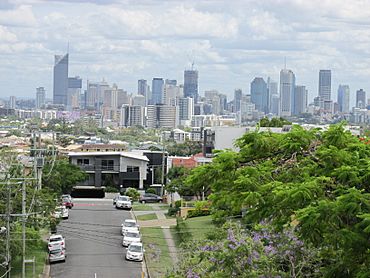
Brisbane Central Business District viewed from Greenslopes, 2017
|
|||||||||||||||
| Population | 7,941 (2021 census) | ||||||||||||||
| • Density | 3,180/km2 (8,200/sq mi) | ||||||||||||||
| Postcode(s) | 4120 | ||||||||||||||
| Area | 2.5 km2 (1.0 sq mi) | ||||||||||||||
| Time zone | AEST (UTC+10:00) | ||||||||||||||
| Location | 6.0 km (4 mi) S of Brisbane CBD | ||||||||||||||
| LGA(s) | City of Brisbane (Coorparoo Ward) |
||||||||||||||
| State electorate(s) | Greenslopes | ||||||||||||||
| Federal Division(s) | Griffith | ||||||||||||||
|
|||||||||||||||
Greenslopes is a suburb located south of Brisbane, a big city in Queensland, Australia. It's about 6 kilometers (or 3.7 miles) away from the center of Brisbane. In 2021, about 7,941 people lived here.
Contents
What is Greenslopes Like?
Greenslopes is about 6 kilometers south of Brisbane's main post office. It has a major highway, the Pacific Motorway, on its western side. This highway is also known as the Southeast Freeway. There's also the South East Busway, which is a special road for buses.
Key Roads and Waterways
Logan Road is a main road that runs through Greenslopes. It comes from Stones Corner in the north and goes towards Holland Park West in the south.
Norman Creek flows into Greenslopes from the southwest. It then leaves the suburb to the north and eventually joins the Brisbane River. The land in Greenslopes changes a bit, with some small hills in the east and south. These hills slope down to the flat area near Norman Creek.
Important Places in Greenslopes
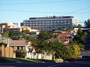
Most of Greenslopes is made up of homes, but there are also some shops. In the southwest part of the suburb, you'll find the Greenslopes Private Hospital. There's also an Energex office and service center, which deals with electricity.
There's a small hill called Stephens Mountain in the southwest of Greenslopes. It's about 55 meters (180 feet) high. This hill is located between the Greenslopes Private Hospital and the Pacific Motorway. Even though it's a low hill, its highest parts are still covered in natural bushland.
A Look at Greenslopes' Past
Greenslopes got its name from an old property in the area. This property was owned by Frederick Wecker, who bought the land in 1857. He called it "Greenslopes" because of its green fields.
Early Land Sales and Development
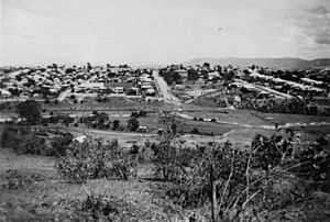
In July 1887, a large area called "Baynes' Paddock" was sold off in 471 smaller pieces. These pieces of land were along important streets like Logan Road and Cornwall Street. An old map from that time shows that there were bus stops and a railway station nearby.
Greenslopes used to be part of a larger area called Stephens Shire. But in 1925, Stephens Shire joined with over 20 other local areas to form Greater Brisbane. You can still see a plaque with the shire's name on the bridge where Juliette Street crosses Norman Creek.
Schools and Churches
Mount Pleasant Provisional School opened on July 30, 1890, with 65 students. It was later renamed Dunellan Provisional School, then Dunellan State School in 1892, and finally Greenslopes State School in 1922.
A small Baptist church was built in Cedar Street in 1900. In 1913, it was moved to the corner of Dunellan Street and Henry Street. A new, bigger brick church was officially opened there on October 14, 1933. This church could seat 300 people and had special rooms for the minister and choir. It is now listed on the Brisbane Heritage Register because of its historical importance.
Transport and Hospitals
The Brisbane City Council used to run trams along Logan Road to Greenslopes from 1914 until 1969. There was also a tram line along Chatsworth Road until 1957.
During World War II in 1942, the Repatriation General Hospital (RGH) opened in Greenslopes. It was built to care for soldiers who had returned from war. In 1995, the government sold the hospital to a private company called Ramsay Health Care. However, it still cares for veterans, and also treats other private patients. The hospital has grown a lot and now offers many special services, like heart care and robotic surgery. Some of the older buildings on the hospital site are protected because of their history.
Changes to Suburb Boundaries
In 1975, the suburb of Stones Corner became part of Greenslopes. But in November 2017, Stones Corner was officially made its own suburb again.
Before August 2015, Greenslopes was part of the Holland Park Ward, which is an area for local government elections. After August 2015, it became part of the Coorparoo Ward, along with other suburbs like Annerley and Coorparoo.
Who Lives in Greenslopes?
In 2021, Greenslopes had a population of 7,941 people.
In 2011, there were 8,565 residents. The average age was 32, which is younger than the average age for all of Australia. Most people (64.1%) were born in Australia. Other common birthplaces included India (4.3%), England (3.2%), and New Zealand (3.1%).
Most people in Greenslopes spoke English at home (74%). Other languages spoken included Punjabi, Hindi, and Mandarin. The most common religions were Catholic (25.7%) and 'No Religion' (25%).
Greenslopes has a population density of about 2,913 people per square kilometer. This is much higher than Brisbane's average. Many people in Greenslopes live in apartments (48.7%), while others live in separate houses (42.6%).
Historical Buildings and Sites
Greenslopes has several sites that are listed for their heritage value, meaning they are important historical places:
- De Aar (an old house), 80 Chatsworth Road
- Tram Shelter, outside 81 Chatsworth Road
- Greenslopes Baptist Church & Hall, 43 Dunellan Street
- Australian Red Cross Centre, 55 Headfort Street
- Chatsworth, 15 Jordan Street
- Greenslopes State School & Mural, 571 Logan Road
- Fig Tree, outside 634 Logan Road
- Parnwell Residence, 684 Logan Road
- Greenslopes Private Hospital, including its main administration block and chapel, 83 Nicholson Street
Learning in Greenslopes
Greenslopes State School is a public primary school for students from Prep to Year 6. It's located at 559 Logan Road. In 2018, the school had 337 students.
There are no high schools directly in Greenslopes. Students usually go to nearby high schools like Coorparoo Secondary College in Coorparoo, Cavendish Road State High School in Holland Park, or Yeronga State High School in Yeronga.
Health and Community Services
The Greenslopes Private Hospital is a major hospital located at 121 Newdegate Street. It is run by Ramsay Health Care, a company that manages many hospitals.
Places of Worship
Greenslopes has several places where people can worship:
- Greenslopes Baptist Church, on the corner of Henry and Dunellan Streets
- St Maroun's Maronite Catholic Church, 29 Bunya Street
- Givat Zion, South Brisbane Hebrew Congregation, 46 Bunya Street
 | James Van Der Zee |
 | Alma Thomas |
 | Ellis Wilson |
 | Margaret Taylor-Burroughs |


