
Coorparoo, Queensland facts for kids
Quick facts for kids CoorparooBrisbane, Queensland |
|||||||||||||||
|---|---|---|---|---|---|---|---|---|---|---|---|---|---|---|---|

Coorparoo State School
|
|||||||||||||||

Coorparoo
Location in Queensland
|
|||||||||||||||
| Postcode(s) | 4151 | ||||||||||||||
| Area | 5.4 km2 (2.1 sq mi) | ||||||||||||||
| Time zone | AEST (UTC+10:00) | ||||||||||||||
| Location | 5.7 km (4 mi) SE of Brisbane CBD | ||||||||||||||
| LGA(s) | City of Brisbane (Coorparoo Ward) |
||||||||||||||
| State electorate(s) | Greenslopes | ||||||||||||||
| Federal Division(s) | Griffith | ||||||||||||||
|
|||||||||||||||
Coorparoo (pronounced KOO-pə-ROO) is a busy suburb located in the inner part of Brisbane, Queensland, Australia. It's a great place to live, with lots of history and things to do. In 2021, about 18,132 people called Coorparoo home.
Contents
Exploring Coorparoo's Location
Coorparoo is about 5.7 kilometers (3.5 miles) south-east of the main Brisbane city center. It shares its borders with several other suburbs. These include Camp Hill, Holland Park, Stones Corner, Greenslopes, East Brisbane, and Norman Park.
What's in a Name? Coorparoo's Meaning
The name Coorparoo was chosen at a public meeting way back in 1875. Before that, the area was known as Four Mile Camp. The name Coorparoo probably comes from an Aboriginal name for Norman Creek. Early surveyors might have written it down as Koolpuroom. People think the word might mean a place with lots of mosquitoes. Another idea is that it refers to the sound made by a 'gentle dove'. However, this second idea is less likely, as the 'gentle dove' (which is actually the spotted dove) only arrived in the area much later, in 1912.
A Journey Through Coorparoo's Past
First Peoples of Coorparoo
The Coorparoo clan, an Aboriginal group, lived south of the Brisbane River. They often set up their camps along the creeks. Their name comes from Kulpurum, which was the word for Norman Creek or one of its smaller streams. Even after European settlers arrived, they continued to use their traditional campsites near the water.
In the past, there were reports of Aboriginal people gathering food along Norman Creek. In 1853, a significant gathering or meeting happened between different Aboriginal groups at Norman Creek. Visitors in 1855 noted many camps and fishing spots between Stones Corner and the mouth of Norman Creek. An elderly woman in 1959 shared stories of frequent corroborees (traditional Aboriginal ceremonies) held on the banks of the creek in Norman Park.
How Coorparoo Grew
In 1856, some of the first farms were sold in the area near Stones Corner. Most of these were bought by people looking to invest. A year later, more land was surveyed for sale.
A kind person named Samuel Stevens gave two acres of his land for a school. This land was near where Cavendish and Old Cleveland Roads meet today. He even turned down the chance to have the area named "Steven's Town."
.jpg)
The Coorparoo State School first opened its doors in 1876. Around the same time, public transport began with a wagonette (a type of horse-drawn wagon) taking people from Coorparoo Junction to Victoria Bridge. The 1880s saw a big boom in land sales. People started dividing up land into smaller blocks to sell. The building of a bridge at Stanley Street in 1886 and new housing areas made Coorparoo even more appealing. By 1887, the tram line was extended to Buranda, making it easier for people in western Coorparoo to travel.
.jpg)
Coorparoo was part of the Bulimba Divisional Board for a while. But in 1888, people wanted their own local government. So, the Shire of Coorparoo was created. This led to important improvements like a new bridge and better roads. By 1889, about 2,500 people lived in the shire.
The Coorparoo Wesleyan Methodist Church opened in 1886. The church building you see today opened in 1959. Later, in 1977, the Methodist Church joined with others to become the Uniting Church of Australia. It is now known as Faith Works Uniting Community.
The floods of 1889 and 1893 caused problems for the lower areas of Coorparoo. This, along with an economic downturn in the 1890s, slowed down development. By 1900, there were actually fewer houses than ten years before. The area was quite built up from Stones Corner to Kirkland Avenue. But further out, it was mostly bush with a few farms.
After World War I, land prices went up, and property sales boomed. Coorparoo really started to grow again when the tram service was extended to Stones Corner in 1902 and Coorparoo Junction in 1915. The number of houses almost doubled in ten years, from 613 in 1911 to 1,467 in 1921.
During World War II, a house called Erica on Cavendish Road was used as a recovery home for soldiers. After the war, in 1946, a charity bought the property. They turned it into the Xavier Home for Children with Special Needs. At first, it helped children who had polio. Over the years, the home grew and helped children with various needs. In the 1990s, the way children with special needs were cared for changed. The focus shifted to supporting them in their own homes. The Xavier Home officially closed in 1994. The staff then moved to a new location better suited for providing support services. The historic Erica house was later restored and is now part of a retirement community.
In 1970, the Queensland Government opened the Xavier Special School at the Xavier Home. This school provided special education for the children living there. After the home closed, the school continued to operate. In 2002, it became part of Whites Hill State College. In 2010, it moved to Nursery Road Special School, which had better facilities for its special teaching methods.
In 2009, the Myer department store building was taken over by the government for a new busway project. The old Myer building was taken down in 2015. In its place, three residential towers with shops on the ground floor were built. This new development, called Coorparoo Square, opened in 2017. It has a 10-screen Dendy cinema, an Aldi Supermarket, and other shops and cafes. The planned Coorparoo bus station was not built there, but space was left for a future busway station.
In 2011, the Brisbane School of Distance Education moved to Coorparoo. This school helps students learn from home, from early childhood all the way to Year 12.
Coorparoo's Population Snapshot
Coorparoo has seen steady growth in its population over the years.
| Census | Population |
|---|---|
| 2001 census | 13243 |
| 2006 census | 13800 |
| 2011 census | 14944 |
| 2016 census | 16282 |
| 2021 census | 18132 |
In 2016, Coorparoo had 16,282 people. The average age was 34, which is younger than the Australian average. About 70.7% of people were born in Australia. Other common birthplaces included India, New Zealand, and England. Most people spoke English at home. When it came to religion, many people reported having No Religion, followed by Catholic and Anglican.
Historic Places in Coorparoo
Coorparoo has many places that are listed for their historical importance. These are special sites that tell us about the suburb's past. Some of these include:
- 67 Cavendish Road: Coorparoo railway station
- 208 Cavendish Road: Coorparoo School of Arts and RSL Memorial Hall (also known as Coorparoo Shire Hall)
- 219 Cavendish Road: former Coorparoo Fire Station
- 398 Cavendish Road: former Erica (also known as Xavier Hospital)
- 427 Cavendish Road: Loreto College
- 12 Main Avenue: Coorparoo Substation No. 210
- 165 Old Cleveland Road: St James Catholic Church & Presbytery
- 327–335 Old Cleveland Road: Coorparoo State School
- 347 Old Cleveland Road: Queen Alexandra Home (also known as Hatherton and Alexandra House)
- 34 Sixth Avenue: Villanova College (also known as Langlands)
- 9 York Street: Coorparoo Uniting Church & Hall
Learning in Coorparoo
Coorparoo is home to many schools, offering education from primary to secondary levels.
- Coorparoo State School is a government primary school (Prep–6) located at 327 Old Cleveland Road. It also has a special education program.
- St James Primary School is a Catholic primary school (Prep–6) at 92 Kirkland Avenue.
- Our Lady of Mount Carmel School is a Catholic primary school (Prep–6) on Norfolk Street.
- Brisbane School of Distance Education is a government school (Early Childhood to Year 12) that helps students learn from home. It's located on the corner of Stanley Street and Cavendish Road.
- Villanova College is a Catholic school for boys (Years 5–12) at 24 Sixth Avenue.
- Coorparoo Secondary College is a government high school (Years 7–12) on the corner of Stanley Street East and Cavendish Road. It also has a special education program.
- Loreto College Coorparoo is a Catholic high school for girls (Years 7–12) at 415 Cavendish Road.
- Queensland Pathways State College is a government high school (Years 10–12) at 327 Old Cleveland Road.
Fun and Facilities in Coorparoo
The Brisbane City Council looks after 30 parks in Coorparoo. These parks come in different sizes and offer various facilities for everyone to enjoy.
Even though it's called the Coorparoo Cricket Club, its clubhouse is actually in Norman Park. Their home games are played at Peter Burge Oval.
Coorparoo is also home to the Eastern Suburbs District Rugby League Football Club. They play their home games at Langlands Park. This park is so good that the Queensland and Australian Rugby League teams often train there when they are playing in Brisbane.
The Brisbane Lions, a professional Australian rules football team, train during the week at Giffin Park in Coorparoo.
The Metropolitan Districts Netball Association has 12 netball courts at Wembley Park, on the corner of Burke Street and Robinson Street.
Faith Works Uniting Community is a church located at 260 Cavendish Road.
Coorparoo's Unique Sights


Coorparoo has many interesting homes, buildings, and places to see:
- Spanish Mission Revival homes along Cavendish Road. These houses have a special style that was popular between the two World Wars.
- Ridgelands (built in the 1880s) was built for the Blundell family.
- Cardington (1880s) is at the corner of Norfolk Street and Cavendish Road.
- Barston Place (1880) on Norfolk Street was named after the birthplace of its first owner, James Burstall.
- Coorparoo Shire Hall (1892) is at the corner of Cavendish Road and Halstead Street. It's now known as The School of Arts Hall.
- A Restored Tram Post can be seen at the corner of Old Cleveland and Cavendish Roads. It reminds us of the old tram lines.
- Hatherton (1886) was a grand home built for Reuben Nicklin. It has been changed a lot over the years and is now known as the heritage-listed "Queen Alexandra Home".
- Chatsworth (1888) was built for William Evans. Chatsworth Road is named after this house.
- Langlands (1883) was also built for Reuben Nicklin. This building is now part of Villanova College and is the oldest stone house still standing in Coorparoo.
- Kirkland Avenue is a street lined with trees that offers views of the Brisbane CBD.
Images for kids
-
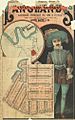
Real estate map of Langlands Estate East, Coorparoo, 1886
-
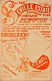
Estate map of the Seville Estate, Cavendish Road, Coorparoo, Brisbane, Queensland, 1888.
-
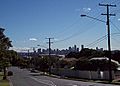
Brisbane Central Business District viewed from Upper Cornwall Street, Coorparoo.
-
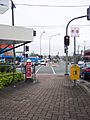
Tram Post
