Moorooka, Queensland facts for kids
Quick facts for kids MoorookaBrisbane, Queensland |
|||||||||||||||
|---|---|---|---|---|---|---|---|---|---|---|---|---|---|---|---|

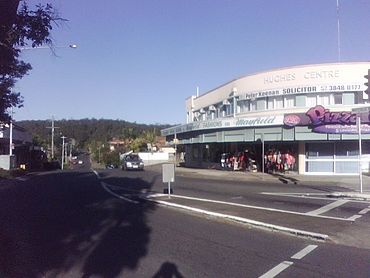
Hughes Centre and Toohey Forest, from Beaudesert Road
|
|||||||||||||||
| Population | 10,783 (2021 census) | ||||||||||||||
| • Density | 2,630/km2 (6,800/sq mi) | ||||||||||||||
| Postcode(s) | 4105 | ||||||||||||||
| Area | 4.1 km2 (1.6 sq mi) | ||||||||||||||
| Time zone | AEST (UTC+10:00) | ||||||||||||||
| Location | 9.0 km (6 mi) S of Brisbane CBD | ||||||||||||||
| LGA(s) | City of Brisbane (Moorooka Ward) |
||||||||||||||
| State electorate(s) |
|
||||||||||||||
| Federal Division(s) | Moreton | ||||||||||||||
|
|||||||||||||||
Moorooka is a lively suburb located in the southern part of Brisbane, Queensland, Australia. It's a place where many different cultures come together. In 2021, about 10,783 people called Moorooka home. This suburb is known for its interesting mix of homes, shops, and green spaces.
Contents
Exploring Moorooka's Location
Moorooka is about 9 kilometers (5.6 miles) south of Brisbane's main city area. It's easy to get to by car or public transport.
Main Roads and Transport
Two important roads, Ipswich Road and Beaudesert Road, run through Moorooka. These roads connect the suburb to other parts of Brisbane. The Gold Coast railway line also passes by, and you can catch a train at the Moorooka railway station.
Moorvale Neighbourhood
Inside Moorooka, there's a special area called Moorvale. This neighbourhood is where Beaudesert Road and Mayfield Road meet. It's a busy spot with lots of shops and businesses.
What Moorooka Looks Like
Moorooka has different types of areas. On the higher eastern side, you'll find mostly homes. The lower western side is home to many car dealerships along Ipswich Road, often called the "Magic Mile." There are also light industries and warehouses here.
Many houses in Moorooka are older "Queenslander" style homes. These are wooden houses built on stilts. Some older homes are being updated or replaced with new buildings. If you go to the top of the hills, you can see amazing views of the Great Dividing Range and the city!
Moorooka's Past: A Glimpse into History
Moorooka has a rich history, starting with its traditional owners.
Traditional Land and Name
The land where Moorooka stands today traditionally belongs to the Australian Aboriginal Jagera people. They lived here for a very long time before European settlers arrived. The name "Moorooka" comes from an Indigenous word. It might mean 'iron bark,' referring to the many iron bark trees in the area. Or it could mean 'long nose,' which might refer to a nearby hill called Mt Toohey.
Early Days and Development
Moorooka became a popular stop for people travelling south from Brisbane. It was a good place to rest and get supplies. Over the years, different parts of Moorooka were sold off as land for homes. Maps from the late 1800s show how the area was divided up. People were keen to buy land here because it was close to the city and had good soil for gardening.
Schools and Community Life
As more families moved to Moorooka, schools were built. Moorooka State School opened its doors in 1929. St Brendan's Catholic Primary School also started in 1929. These schools helped the community grow.
For many years, from the 1930s to 1969, trams ran through Moorooka, making it easy for people to travel to the city.
Moorooka's "Little Africa" Connection
In the early 2000s, many new settlers from African countries like South Sudan, Somalia, and Ethiopia made Moorooka their home. Because of this, Moorooka is now sometimes called "Little Africa" in Brisbane. It's a place where African culture thrives, with special shops and businesses.
Moorooka Bowls Club
The Brisbane City Council built The Moorooka Bowls Club in 1968. This club even hosted Queen Elizabeth II when she visited for the 1982 Commonwealth Games! Today, it's becoming a community space for everyone to enjoy.
Who Lives in Moorooka?
Moorooka is a diverse suburb with people from many different backgrounds.
In 2021, Moorooka had a population of 10,783 people. Most people living in Moorooka were born in Australia. However, many residents also come from countries like New Zealand, England, India, Vietnam, and Iran. English is the most common language spoken at home, but you'll also hear Vietnamese, Spanish, Punjabi, Mandarin, and Greek. This mix of cultures makes Moorooka a vibrant and interesting place to live.
Historic Places in Moorooka
Moorooka has some buildings that are important to its history. These are called heritage-listed sites.
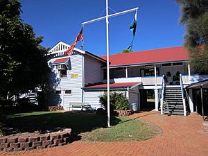
- Sherley Street: Moorooka State School
Moorooka State School Heritage
The Moorooka State School building on Sherley Street is a heritage-listed site. This means it's an important part of the area's history and is protected.
Learning in Moorooka
Moorooka has good schools for younger students.
Primary Schools
- Moorooka State School is a government primary school for students from Prep to Year 6. It's located on Sherley Street. The school has a strong multicultural community and hosts a fun annual festival in July.
- St Brendan's Primary School is a Catholic primary school for students from Prep to Year 6. It's on Hawtree Street.
There are no high schools directly in Moorooka. Older students usually go to Yeronga State High School in nearby Yeronga. Moorooka also has two kindergartens for younger children.
Things to Do and See in Moorooka
Moorooka has many places to shop, eat, and connect with the community.
Shopping and Food
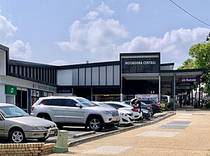
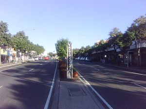
The main shopping area in Moorooka is on Beaudesert Road, in the Moorvale neighbourhood. Here, you'll find over 100 different businesses! There are takeaways, restaurants, coffee shops, newsagents, and even shops that serve the African community. You can find special groceries, hair salons, and furniture shops.
Churches
Moorooka has two main churches: St Brendan's Roman Catholic Church on Hawtree Street and the Church of Christ on Pampas Street and Beaudesert Road. Both offer Sunday services.
Getting Around Moorooka
Moorooka is well-connected by public transport.
Trains
Commuter trains on the Beenleigh line stop at Moorooka railway station. This makes it easy to travel to other parts of Brisbane.
Buses
The suburb is also served by Transport for Brisbane buses. Several bus routes pass through Moorooka, connecting it to places like Inala, Rocklea, Sunnybank, and the city center. There's even a special "zone border crossing" for transport zones 1 and 2 at the Beaudesert Road shops.
 | Bayard Rustin |
 | Jeannette Carter |
 | Jeremiah A. Brown |


