Tavernier, Florida facts for kids
Quick facts for kids
Tavernier, Florida
|
|
|---|---|

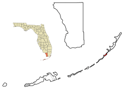
Location in Monroe County and the state of Florida
|
|

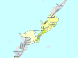
U.S. Census Bureau map showing CDP boundaries
|
|
| Country | United States |
| State | Florida |
| County | Monroe |
| Area | |
| • Total | 2.64 sq mi (6.83 km2) |
| • Land | 2.51 sq mi (6.51 km2) |
| • Water | 0.12 sq mi (0.32 km2) |
| Elevation | 7 ft (2 m) |
| Population
(2020)
|
|
| • Total | 2,530 |
| • Density | 1,006.36/sq mi (388.63/km2) |
| Time zone | UTC-5 (Eastern (EST)) |
| • Summer (DST) | UTC-4 (EDT) |
| ZIP code |
33070
|
| Area code(s) | 305 |
| FIPS code | 12-71250 |
| GNIS feature ID | 0292061 |
Tavernier is a small community in Florida, United States. It is located on Key Largo, which is the biggest island in the upper Florida Keys. In 2020, about 2,530 people lived in Tavernier. It is a special type of community called a census-designated place (CDP). This means it's a place the government counts for population, even though it's not officially a city or town.
Contents
Where is Tavernier?
Tavernier is located at coordinates 25°0′55″N 80°30′49″W / 25.01528°N 80.51361°W. It covers the southwestern part of Key Largo, which is the largest of the Florida Keys.
To the northeast of Tavernier, you'll find the community of Key Largo. To the southwest, across a small waterway called Tavernier Creek, is the village of Islamorada on Plantation Key.
The main road through Tavernier is U.S. Route 1, also known as the Overseas Highway. This highway stretches for many miles. It goes southwest about 90 miles to Key West and northeast about 64 miles to Miami.
The total area of Tavernier is about 2.6 square miles. Most of this area is land, but about 0.1 square miles is water.
What is the Climate Like?
Tavernier has a tropical savanna climate. This means it's usually warm all year round. It has a wet season and a dry season, but it never gets truly cold.
| Climate data for Tavernier, Florida (1991-2020 normals, extremes 1936–2009) | |||||||||||||
|---|---|---|---|---|---|---|---|---|---|---|---|---|---|
| Month | Jan | Feb | Mar | Apr | May | Jun | Jul | Aug | Sep | Oct | Nov | Dec | Year |
| Record high °F (°C) | 87 (31) |
87 (31) |
90 (32) |
94 (34) |
94 (34) |
97 (36) |
97 (36) |
98 (37) |
98 (37) |
94 (34) |
90 (32) |
89 (32) |
98 (37) |
| Mean maximum °F (°C) | 82.1 (27.8) |
82.8 (28.2) |
84.4 (29.1) |
86.7 (30.4) |
88.6 (31.4) |
91.1 (32.8) |
92.5 (33.6) |
93.0 (33.9) |
91.3 (32.9) |
88.8 (31.6) |
85.4 (29.7) |
82.9 (28.3) |
93.6 (34.2) |
| Mean daily maximum °F (°C) | 75.2 (24.0) |
77.2 (25.1) |
78.9 (26.1) |
82.6 (28.1) |
85.5 (29.7) |
88.0 (31.1) |
89.3 (31.8) |
89.7 (32.1) |
87.8 (31.0) |
84.7 (29.3) |
80.5 (26.9) |
77.2 (25.1) |
83.1 (28.4) |
| Daily mean °F (°C) | 69.5 (20.8) |
71.3 (21.8) |
73.1 (22.8) |
77.1 (25.1) |
80.3 (26.8) |
82.9 (28.3) |
84.4 (29.1) |
84.4 (29.1) |
82.9 (28.3) |
80.1 (26.7) |
75.3 (24.1) |
71.9 (22.2) |
77.8 (25.4) |
| Mean daily minimum °F (°C) | 63.9 (17.7) |
65.4 (18.6) |
67.3 (19.6) |
71.6 (22.0) |
75.1 (23.9) |
77.9 (25.5) |
79.6 (26.4) |
79.0 (26.1) |
78.1 (25.6) |
75.4 (24.1) |
70.1 (21.2) |
66.7 (19.3) |
72.5 (22.5) |
| Mean minimum °F (°C) | 47.9 (8.8) |
50.0 (10.0) |
54.9 (12.7) |
60.5 (15.8) |
68.4 (20.2) |
71.5 (21.9) |
73.0 (22.8) |
72.6 (22.6) |
72.5 (22.5) |
67.7 (19.8) |
58.3 (14.6) |
52.0 (11.1) |
45.2 (7.3) |
| Record low °F (°C) | 35 (2) |
39 (4) |
40 (4) |
51 (11) |
61 (16) |
65 (18) |
69 (21) |
66 (19) |
66 (19) |
55 (13) |
42 (6) |
35 (2) |
35 (2) |
| Average precipitation inches (mm) | 2.11 (54) |
2.17 (55) |
1.64 (42) |
1.91 (49) |
3.81 (97) |
5.58 (142) |
3.98 (101) |
5.64 (143) |
7.98 (203) |
5.64 (143) |
2.40 (61) |
2.13 (54) |
44.99 (1,143) |
| Average precipitation days (≥ 0.01 in) | 5.6 | 4.4 | 5.2 | 4.8 | 5.8 | 11.1 | 9.4 | 12.4 | 13.3 | 11.7 | 6.0 | 6.4 | 96.1 |
| Source: NOAA | |||||||||||||
Who Lives in Tavernier?
The number of people living in Tavernier has changed over the years.
| Historical population | |||
|---|---|---|---|
| Census | Pop. | %± | |
| 1980 | 1,834 | — | |
| 1990 | 2,433 | 32.7% | |
| 2000 | 2,173 | −10.7% | |
| 2010 | 2,136 | −1.7% | |
| 2020 | 2,530 | 18.4% | |
| U.S. Decennial Census | |||
2020 Census Information
In 2020, the census counted 2,530 people living in Tavernier. There were 768 households, which means groups of people living together, and 462 families.
The table below shows the different groups of people living in Tavernier based on the 2020 census:
| Group | Number | Percentage |
|---|---|---|
| White (not Hispanic) | 1,595 | 63.04% |
| Black or African American (not Hispanic) | 25 | 0.99% |
| Native American | 10 | 0.4% |
| Asian | 17 | 0.67% |
| Other/mixed | 62 | 2.45% |
| Hispanic or Latino | 821 | 32.45% |
Schools in Tavernier
Public schools in Tavernier are managed by the Monroe County School District.
Most students living in Tavernier go to Plantation Key School, which is located on Plantation Key.
For high school, students attend Coral Shores High School. Even though it has a Tavernier address, the school is actually located in Islamorada.
Famous People from Tavernier
- William O'Brien was the 21st police chief of Miami.
See also
 In Spanish: Tavernier (Florida) para niños


