Teewinot Mountain facts for kids
Quick facts for kids Teewinot Mountain |
|
|---|---|

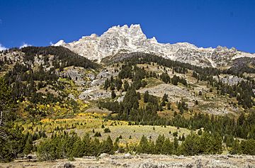
East face of Teewinot Mountain from Jackson Hole
|
|
| Highest point | |
| Elevation | 12,330 ft (3,760 m) NAVD 88 |
| Prominence | 805 ft (245 m) |
| Geography | |
| Location | Grand Teton National Park, Teton County, Wyoming, U.S. |
| Parent range | Teton Range |
| Topo map | USGS Grand Teton |
| Climbing | |
| First ascent | 1929 (Fryxell) |
| Easiest route | Climb, class 4 |
Teewinot Mountain is a super tall mountain in Grand Teton National Park, Wyoming. It stands at about 12,330 feet (3,758 meters) high! This makes it one of the tallest peaks in the famous Teton Range.
The name "Teewinot" comes from the Shoshone Native American people. It means "many pinnacles," which is a perfect name for a mountain with so many pointy tops! Teewinot Mountain is located northeast of the even bigger Grand Teton mountain. These two giant peaks are separated by the Teton Glacier and another mountain called Mount Owen.
Imagine looking up from Jenny Lake; Teewinot Mountain rises more than 5,500 feet (1,700 meters) above the water! The Teton Range, which is about 40 miles (64 kilometers) long, is actually the youngest mountain chain in the Rocky Mountains. It started forming about 9 million years ago. Over time, huge sheets of ice called glaciers carved out the amazing shapes you see in Teewinot Mountain and the other peaks today. You can even see Broken Falls, a beautiful waterfall that drops 300 feet (91 meters) down the eastern side of Teewinot Mountain.
Exploring Teewinot Mountain
Teewinot Mountain is a popular spot for people who love to climb. It's known for its exciting routes and amazing views.
How to Climb Teewinot Mountain
The easiest way to climb Teewinot Mountain is from its eastern side. This path involves a bit of a "scramble" near the top. A scramble means you'll need to use both your hands and feet to climb over rocks, but it's not as difficult as full-on rock climbing. This part is rated as "Class 4" on the Yosemite Decimal System, which means it's a challenging hike where a fall could be dangerous, but ropes are usually not needed. The very top of the mountain is quite small!
There's a path called the Apex Trail that climbers often use. It's not marked with signs, but it leads most of the way up the mountain from an area called Lupine Meadows.
 | Aurelia Browder |
 | Nannie Helen Burroughs |
 | Michelle Alexander |


