Teknaf Upazila facts for kids
Quick facts for kids
Teknaf
টেকনাফ
|
|
|---|---|

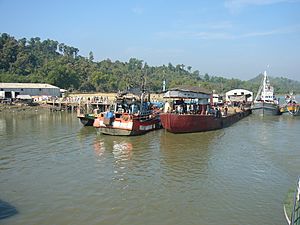
View of the Launch Terminal of Teknaf Bangladesh
|
|
| Country | |
| Division | Chittagong Division |
| District | Cox's Bazar District |
| Area | |
| • Total | 388.68 km2 (150.07 sq mi) |
| Population
(1991)
|
|
| • Total | 152,557 |
| • Density | 393/km2 (1,020/sq mi) |
| Time zone | UTC+6 (BST) |
Teknaf (Bengali: টেকনাফ Ṭeknaf) is a special type of area in Bangladesh called an upazila. Think of an upazila like a county or a sub-district. It's located in the Cox's Bazar District, which is part of the Chittagong Division.
Teknaf is super important because it's the most southern point on the mainland of Bangladesh. There's an island called St. Martin's Island that's even further south, but Teknaf is as far south as you can go on the main land. The area gets its name from the Naf River, which forms its eastern border. This river also acts as a border with the country of Myanmar, right across from a town called Maungdaw.
Contents
Exploring Teknaf's Geography
Teknaf is found at coordinates 20.8667° N and 92.3000° E. It covers a total area of about 388.68 square kilometers. That's roughly 150 square miles!
The Unique Teknaf Peninsula
The Teknaf Peninsula is home to one of the longest sandy beaches in the world, stretching for 80 kilometers (about 50 miles). This area is a special meeting point for animals from two different parts of Asia: the Indo-Himalayan and Indo-Malayan regions.
You can find many different types of natural places here, like:
- Mangrove forests
- Mudflats
- Sandy beaches and dunes
- Canals and lagoons
- Marine (ocean) habitats
Mangrove forests are special trees that grow in salty water. They are found all over the Teknaf peninsula, both naturally and in planted areas, especially where the ocean tides come in. These mangrove forests are a home for 161 different kinds of fish! Teknaf also has one of the oldest protected forests in Bangladesh.
Understanding Teknaf's Climate
Teknaf has a tropical monsoon climate. This means it has warm, dry winters and very warm, extremely rainy summers.
| Climate data for Teknaf | |||||||||||||
|---|---|---|---|---|---|---|---|---|---|---|---|---|---|
| Month | Jan | Feb | Mar | Apr | May | Jun | Jul | Aug | Sep | Oct | Nov | Dec | Year |
| Mean daily maximum °C (°F) | 27.2 (81.0) |
28.8 (83.8) |
30.8 (87.4) |
31.9 (89.4) |
32.1 (89.8) |
30.3 (86.5) |
29.8 (85.6) |
30.0 (86.0) |
30.7 (87.3) |
31.4 (88.5) |
30.2 (86.4) |
28.1 (82.6) |
30.1 (86.2) |
| Mean daily minimum °C (°F) | 15.1 (59.2) |
17.1 (62.8) |
20.6 (69.1) |
23.9 (75.0) |
25.2 (77.4) |
25.2 (77.4) |
25.0 (77.0) |
24.9 (76.8) |
24.9 (76.8) |
24.0 (75.2) |
21.1 (70.0) |
17.0 (62.6) |
22.0 (71.6) |
| Average precipitation mm (inches) | 1.9 (0.07) |
16.5 (0.65) |
15.3 (0.60) |
73.0 (2.87) |
259.9 (10.23) |
968.1 (38.11) |
1,029.7 (40.54) |
898.9 (35.39) |
402.1 (15.83) |
207.4 (8.17) |
75.4 (2.97) |
5.9 (0.23) |
3,954.1 (155.66) |
| Average precipitation days | 1 | 2 | 2 | 5 | 12 | 21 | 25 | 24 | 15 | 8 | 4 | 1 | 120 |
| Average relative humidity (%) | 69 | 68 | 73 | 77 | 81 | 88 | 90 | 89 | 87 | 83 | 77 | 71 | 79 |
| Source: Bangladesh Meteorological Department | |||||||||||||
People and Population of Teknaf
In 1991, a count of the population (called a census) showed that Teknaf had 152,557 people living there. Slightly more than half of the population (51.81%) were males, and 48.19% were females.
About 64,417 people were 18 years old or older. The average literacy rate in Teknaf was 16.6% for people aged 7 and up. This means 16.6% of people could read and write. The national average for Bangladesh at that time was higher, at 32.4%.
How Teknaf is Managed
Teknaf Upazila is divided into a main town area called Teknaf Municipality and six smaller areas called union parishads. These union parishads are like local councils.
The six union parishads are:
- Baharchara
- Hnila
- Sabrang
- Saint Martin
- Teknaf
- Whykong
These union parishads are further divided into even smaller sections called mauzas and villages. There are 12 mauzas and 146 villages in total. The Teknaf Municipality itself is divided into 9 wards and 16 mahallas, which are like neighborhoods.
See also
 In Spanish: Teknaf para niños
- Cox's Bazar District topics
- List of Upazilas of Bangladesh
- Upazilas of Chittagong District
 | Precious Adams |
 | Lauren Anderson |
 | Janet Collins |


