
St. Martin's Island facts for kids
|
Native name:
সেন্টমার্টিন দ্বীপ (Senṭmarṭin dip)
নারিকেল জিঞ্জিরা (Narikel jinjira) দারুচিনি দ্বীপ (Daruchini dip) |
|||||||||
|---|---|---|---|---|---|---|---|---|---|
 |
|||||||||
| Geography | |||||||||
| Location | Bay of Bengal | ||||||||
| Coordinates | 20°36′47″N 92°19′36″E / 20.61306°N 92.32667°E | ||||||||
| Area | 3 km2 (1.2 sq mi) | ||||||||
| Length | 9 km (5.6 mi) | ||||||||
| Width | 0.5 km (0.31 mi) | ||||||||
| Administration | |||||||||
| District | Cox's Bazar District | ||||||||
| Demographics | |||||||||
| Population | 8000 | ||||||||
|
|||||||||
Saint Martin Island (Bengali: সেন্টমার্টিন দ্বীপ, romanized: Senṭmarṭin dip) is a small island in the northeastern part of the Bay of Bengal. It covers only 3 square kilometers. The island is about 9 kilometers south of the Cox's Bazar-Teknaf peninsula. It is the southernmost part of Bangladesh. There is also a tiny island next to it, called Chera Dip. This small island gets separated from Saint Martin Island when the tide is high. Saint Martin Island is about 8 kilometers west of the northwest coast of Myanmar. It sits near the mouth of the Naf River.
Contents
Island History and Names
A very long time ago, Saint Martin Island was connected to the Teknaf peninsula. But over time, part of the land sank. This made the southernmost part of the peninsula become a separate island.
Arabian merchants were the first people to settle on the island in the 1700s. They called it "Jazira." Later, when the British ruled, the island was named after Mr. Martin. He was a British official in Chittagong.
The island has local names too. "Narikel Jinjira" means "Coconut Island." "Daruchini Dip" means "Cinnamon Island." Saint Martin Island is special because it is the only coral island in Bangladesh.
How the Island is Governed
Saint Martin Island is part of a local government area called Saint Martin's Union Parishad. It has nine main villages or areas:

- Paschim Para (Western Neighborhood)
- Deil Para
- Uttar Para (Northern Neighborhood)
- Majher Para (Middle Neighborhood)
- Purba Para (Eastern Neighborhood)
- Konar Para (Edge Neighborhood)
- Nazrul Para (Nazrul's Neighborhood)
- Golachipa (meaning "narrow neck")
- Dakkhin Para (Southern Neighborhood)
Life for Island Residents
About 3,700 people live on Saint Martin Island. Most of them earn a living by fishing. Other important foods grown here are rice and coconuts.

Algae is very common on the island. People collect it, dry it, and send it to Myanmar. From October to April, fishermen from nearby areas bring their fish to the island's market. Food like chicken, meat, and other supplies come from mainland Bangladesh and Myanmar.
Most of the permanent buildings are in the far north of the island. The middle and south parts are mostly farmland and simple huts. During the rainy season, the Bay of Bengal can be very dangerous. This makes it hard for people to travel to the mainland. There is a hospital on the island for medical care.
Amazing Nature and Sea Life
The Bangladesh Department of Environment and the UNDP have studied Saint Martin Island. They found many different natural areas, called ecosystems. These include places rich in coral, mangrove forests, lagoons, and rocky areas.
The island is a safe home for many kinds of animals. In 2010, researchers found:
- 153 types of sea weeds
- 66 types of coral
- 187 types of oysters
- 240 types of fish
- 120 types of birds
- 29 types of reptiles
- 29 types of mammals
In 2022, the area around the island was made a Marine Protected Area. This helps protect the sea life.
Scientists are also studying marine sponges from the island. These sponges and tiny living things inside them can make special compounds. These compounds might be used to create new medicines. For example, some bacteria from sponges can help fish fight diseases.
Getting Around the Island
The only way to reach Saint Martin Island is by boat or ship. Most tourists travel from Cox's Bazar and Teknaf. The island is about 120 kilometers from Cox's Bazar city.
Once on the island, the only way to get around is by non-motorized vans. These vans are pulled by people. The roads are made of concrete and are in good condition.
There is no electricity from the main national power grid. This is because a hurricane damaged the power lines in 1991. Most hotels use generators until 11 PM. After that, they use solar power, which is very popular across the island.
Tourism and Protecting the Island
.jpg)
Saint Martin Island has become a popular place for tourists. Eight different shipping companies offer daily trips to the island. Many tourists now prefer "Eco tourism," which means traveling in a way that protects nature. Tourists can book their trips from Chittagong or Cox's Bazar.
The island has a coral reef that extends to Chera Dwip. Chera Dwip has a small bush, which is its only green part. No one lives on Chera Dwip. Tourists should visit early and return by afternoon.

There are efforts to protect the island's endangered turtles. These turtles lay their eggs on the island. The corals also need protection, as some types are found only here. Sadly, some parts of the coral reef are being taken to sell to tourists. Turtles laying eggs are sometimes caught for food. Baby turtles can get confused by bright lights on the beach.
Fish are also being overfished. Fishermen have to go further out to sea each year to catch fish. Most of them use boats without motors.
You can walk around the entire island in one day. It is only about 8 square kilometers. At high tide, it shrinks to about 5 square kilometers. The island exists because of its coral base. If the coral is removed, the beach could erode away. Between 1980 and 2018, Saint Martin Island lost 70% of its coral reef. This was mainly due to human activities.
Island Climate and Weather
The best time to visit Saint Martin Island is usually from November to February. This is when most tourists come. From March to July, strong storms called cyclones can hit the island. A big cyclone in 1991 caused a lot of damage, but the island has fully recovered. The island was not affected by the 2004 tsunami. The months from March to July are considered the off-season for tourists.
Gallery
-
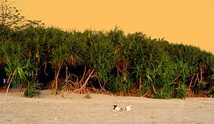
Keya Tree (Pandanus odorifer) of Saint Martin's Island
-
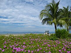
East view of Saint Martins Island
-
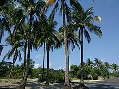
Coconut garden Saint Martins Island
-
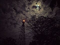
Light house of St. Martin's Island


See also
 In Spanish: Isla de San Martín (Bangladés) para niños
