Tekoa Mountain (Massachusetts) facts for kids
Quick facts for kids Tekoa Mountain |
|
|---|---|

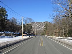
South face of Tekoa Mountain
|
|
| Highest point | |
| Elevation | 1,121 ft (342 m) |
| Parent peak | 42° 10' 07"N, 72° 48' 47"W |
| Naming | |
| English translation | "Trumpet blast" or "place of fastening down" |
| Language of name | Hebrew |
| Geography | |
| Location | Montgomery and Russell, Massachusetts |
| Parent range | Berkshires |
| Geology | |
| Mountain type | Metamorphic rock |
| Climbing | |
| Easiest route | White dot trail starting near the tracks by the Mass Pike bridge. |
Tekoa Mountain is a tall, rocky hill in Massachusetts, USA. It stands about 1,121 feet (342 m) high. This impressive spot overlooks the Westfield River Gorge. It is located where the Berkshire plateau begins, in the towns of Montgomery and Russell, Massachusetts.
Tekoa Mountain is very easy to see from U.S. Route 20 in Russell. It is not a "true" mountain. Instead, it is a large piece of land that sticks out from a flat area. It was shaped by glaciers and the Westfield River over a very long time.
With nearby Shatterack Mountain, Tekoa Mountain forms a tall, rocky cliff. This cliff is about 700 ft (210 m) high. It runs along the northeast side of the Westfield River. The river flows from the Berkshire Mountains into the Connecticut River Valley.
Much of Tekoa Mountain's face is rocky or has few trees. This is partly because of frequent fires. These fires help certain trees like pitch pine and scrub oak to grow. The mountain is also home to the New England cottontail. This rabbit species is becoming rare in Massachusetts. The United States Fish and Wildlife Service sees Tekoa Mountain as a very important area for nature.
Exploring Tekoa Mountain's Location
Tekoa Mountain looks down on the Westfield River Gorge. It also overlooks the wide Connecticut River Valley. The town of Russell and its small villages, Woronoco and Crescent Mills, are at the base of the mountain. They are right along the Westfield River.
From the top of Tekoa Mountain, you can see far away. The cities of Westfield and Springfield, Massachusetts are visible to the east. The southwest and northeast sides of Tekoa Mountain are very steep and rugged. They have many cliffs and rocky viewpoints. To the north, the land slowly gets flatter. There, Tekoa Mountain joins the higher land of Montgomery.
Water flows off Tekoa Mountain in different directions. The southwest side drains into the Westfield River. This river then flows into the Connecticut River and finally into Long Island Sound. The northeast side drains into Moose Meadow Brook. This brook also flows into the Westfield River.
Tekoa Mountain's Past
The area around Tekoa Mountain was first home to Native Americans. They were part of the Woronoake tribe.
During the American Revolutionary War, something secret happened here. On the north side of the mountain, there was a hidden factory. It made muskets for the American side. A settler named Richard Falley Jr. ran this factory. His home was at the base of the mountain. People used the mountain's top as a lookout. They watched for British spies.
Tekoa Mountain was named after an old biblical place called Tekoa. This name can mean "fastening down" or "a trumpet blast." In ancient times, Tekoa was a city built to protect the Judah. Because it was high up, it was a good place for defense. It was also used to send signals to other cities. It is not known if the mountain was named with this history in mind.
Fun Things to Do at Tekoa Mountain
Much of Tekoa Mountain is part of the Tekoa Mountain Wildlife Management Area. This area is looked after by the Division of Fisheries and Wildlife. The eastern part of the mountain belongs to the City of Westfield. This land is for protecting water. But people can still visit it thanks to an agreement with the Division of Fisheries and Wildlife.
These areas are open for activities like hunting and hiking. You can also enjoy other outdoor fun that does not use motors. There are a few small pieces of land here that are privately owned. Tekoa Mountain has many unofficial paths and old roads. However, there are no official marked trails. All vehicles with motors, like ATVs, are not allowed in the Wildlife Management Area. They are also not allowed on the water protection lands.
The mountain and the land around it are part of a big effort to protect nature. The U.S. Fish and Wildlife Service is working to save important habitats. These habitats are found along the greater Connecticut River Valley.
 | May Edward Chinn |
 | Rebecca Cole |
 | Alexa Canady |
 | Dorothy Lavinia Brown |

