The Crossings, Florida facts for kids
Quick facts for kids
The Crossings, Florida
|
|
|---|---|

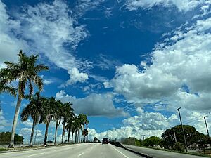
View from Killian Parkway
|
|

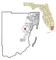
Location in Miami-Dade County and the state of Florida
|
|

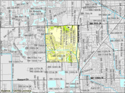
U.S. Census Bureau map showing CDP boundaries
|
|
| Country | |
| State | |
| County | |
| Area | |
| • Total | 3.57 sq mi (9.23 km2) |
| • Land | 3.44 sq mi (8.90 km2) |
| • Water | 0.13 sq mi (0.33 km2) |
| Elevation | 7 ft (2 m) |
| Population
(2020)
|
|
| • Total | 23,276 |
| • Density | 6,770.22/sq mi (2,614.15/km2) |
| Time zone | UTC-5 (Eastern (EST)) |
| • Summer (DST) | UTC-4 (EDT) |
| ZIP Code |
33186 (Miami)
|
| Area code(s) | 305, 786, 645 |
| FIPS code | 12-71567 |
| GNIS feature ID | 1853292 |
The Crossings is a community in Florida, USA. It's like a neighborhood near the big city of Miami. It's part of the larger Miami area in South Florida. This community includes areas called The Crossings, Devon Aire, and Calusa. In 2020, about 23,276 people lived there.
Contents
Where is The Crossings?
The Crossings is about 16 miles southwest of downtown Miami. It has clear borders:
- North: Kendall Drive (SW 88th Street)
- South: SW 120th Street
- East: Florida's Turnpike
- West: SW 137th Avenue
It is surrounded by other communities:
- North: Kendale Lakes
- East: Kendall
- South: Three Lakes
- West: The Hammocks
The Crossings covers about 3.6 square miles (9.3 square kilometers). A small part of this area, about 0.1 square miles, is water.
A Look at History
The neighborhoods that make up The Crossings were built in the 1970s and 1980s. Today, you'll find mostly single-family residences (houses) and townhouses here.
Population Facts
| Historical population | |||
|---|---|---|---|
| Census | Pop. | %± | |
| 1980 | 11,986 | — | |
| 1990 | 22,290 | 86.0% | |
| 2000 | 23,557 | 5.7% | |
| 2010 | 22,758 | −3.4% | |
| 2020 | 23,276 | 2.3% | |
| source: | |||
People in The Crossings (2020)
In 2020, there were 23,276 people living in The Crossings. There were 7,675 households, which are groups of people living together in one home. Out of these, 5,946 were families.
The table below shows the different groups of people living in The Crossings in 2010 and 2020. The US Census counts people by their race and also by whether they are Hispanic or Latino. People who are Hispanic or Latino can be of any race.
| Race / Ethnicity (NH = Non-Hispanic) | Pop 2010 | Pop 2020 | % 2010 | % 2020 |
|---|---|---|---|---|
| White (NH) | 5,100 | 3,597 | 22.41% | 15.45% |
| Black or African American (NH) | 918 | 727 | 4.03% | 3.12% |
| Native American or Alaska Native (NH) | 10 | 12 | 0.04% | 0.05% |
| Asian (NH) | 559 | 542 | 2.46% | 2.33% |
| Pacific Islander or Native Hawaiian (NH) | 1 | 3 | 0.01% | 0.00% |
| Some other race (NH) | 78 | 152 | 0.34% | 0.65% |
| Mixed race or Multiracial (NH) | 289 | 493 | 1.27% | 2.12% |
| Hispanic or Latino (any race) | 15,803 | 17,750 | 69.44% | 76.26% |
| Total | 22,758 | 23,276 | 100.00% | 100.00% |
Schools in The Crossings
Public schools in The Crossings are managed by Miami-Dade County Public Schools. Here are some of the schools in or near the area:
- Calusa Elementary School
- Devon Aire K-8 Center
- Arvida Middle School
- Miami Killian Senior High
See also
In Spanish: The Crossings (Florida) para niños
 | Selma Burke |
 | Pauline Powell Burns |
 | Frederick J. Brown |
 | Robert Blackburn |

