
The Fortress (Alberta) facts for kids
Quick facts for kids The Fortress |
|
|---|---|

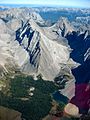
The Fortress (upper center), Mount Chester (right) and Gusty Peak (left and ridge foreground)
|
|
| Highest point | |
| Elevation | 3,000 m (9,800 ft) |
| Prominence | 287 m (942 ft) |
| Geography | |

The Fortress
Location in Alberta

The Fortress
Location in Canada
|
|
| Parent range | Kananaskis Range Canadian Rockies |
| Topo map | NTS 82J/14 |
| Climbing | |
| Easiest route | Scramble on southwest ridge |
The Fortress is a tall mountain in the Canadian Rockies, standing about 3,000 m (9,843 ft) (9,842 feet) high. It is located in Kananaskis Park, Alberta, Canada. When you look at it from Highway 40, the north side of the mountain looks like a strong, old fortress, which is how it got its name!
It's important not to confuse The Fortress with Fortress Mountain Resort, which is a different place nearby. The mountain was first called Tower Mountain. But in 1957, its name was changed to The Fortress. This was done to avoid mixing it up with another mountain called Tower Mountain in British Columbia.
Contents
Climbing The Fortress
Climbing The Fortress is a fun adventure, often called "scrambling." This means you use both your hands and feet to climb up steep, rocky parts. There are two main ways to start climbing the southwest side of the mountain.
Starting Your Climb
You can begin your climb from either the Chester Lake area or the Headwall Lakes area. Both paths lead to a special spot called a "col." A col is like a saddle between two mountains, in this case, between The Fortress and Mount Chester.
Reaching the Summit
From the col, you'll find a steep path that goes up the last 325 m (1,066 ft) (1,066 feet) to the very top. Only the final part of the climb, right before the summit, needs you to use your hands a lot for scrambling.
Choosing Your Path
The path from Headwall Lakes takes a bit longer to climb. However, the slopes leading to the col are not as loose and rocky as the ones from Chester Lake. Because of this, the Chester Lake side is often a better route to use when you are coming back down the mountain.
Mountain Weather
The Fortress is in a place with a subarctic climate. This means it has very cold winters with lots of snow. The summers are usually mild, not too hot. Temperatures can drop below -20 degrees Celsius (-4 degrees Fahrenheit). With the wind chill, it can feel even colder, sometimes below -30 degrees Celsius (-22 degrees Fahrenheit)!
Photo Gallery
-
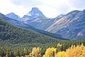
Chester Lake with The Fortress behind
-
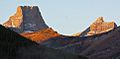
The Fortress and Gusty Peak
-
The Fortress


.jpg)
