The Marshall facts for kids
Quick facts for kids The Marshall |
|
|---|---|

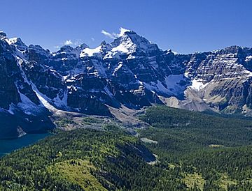
The Marshall seen from Nub Peak
|
|
| Highest point | |
| Elevation | 3,180 m (10,430 ft) |
| Prominence | 410 m (1,350 ft) |
| Parent peak | Mount Assiniboine (3616 m) |
| Geography | |
| Location | Mount Assiniboine Provincial Park British Columbia, Canada |
| Parent range | Canadian Rockies |
| Topo map | NTS 82J13 |
| Geology | |
| Age of rock | Cambrian |
| Type of rock | sedimentary rock |
| Climbing | |
| First ascent | 1919 V.A. Fynn, Rudolph Aemmer |
| Easiest route | Scrambling |
The Marshall is a tall mountain peak in Canada. It stands about 3,180 meters (10,433 feet) high. You can find it in Mount Assiniboine Provincial Park in British Columbia, which is part of the amazing Canadian Rockies. The Marshall is close to an even taller mountain called Mount Assiniboine, which is about 3 kilometers (1.9 miles) away to its east-southeast. This mountain is also located west of Wedgwood Peak.
Contents
The Marshall's History: How it Got its Name
The Marshall mountain got its name in 1913. It was named by a group called the Interprovincial Boundary Survey. They chose the name because the mountain was in a "leading" position.
Why "Marshall"?
The mountain was also sometimes called Centurion Peak. A "centurion" was a Roman army officer. This word is similar to "Field marshal", which is a high-ranking military commander. Both names suggest a leader or someone in charge.
First People to Climb The Marshall
The first time someone successfully climbed to the top of The Marshall was in 1919. A climber named Val Fynn made the climb. He was guided by Rudolph Aemmer, who helped him find the way.
Official Name Adoption
The name "The Marshall" was officially accepted on March 31, 1924. This happened after the Geographical Names Board of Canada approved it.
Geology: What The Marshall is Made Of
The Marshall mountain is made of a type of rock called sedimentary rock. This rock formed a very long time ago, during a period known as the Cambrian period.
How Sedimentary Rock Forms
Sedimentary rock forms in layers, often in shallow seas. Over millions of years, tiny bits of sand, mud, and shells settle at the bottom. These layers get pressed together and turn into solid rock.
Mountain Building: The Laramide Orogeny
Later, these layers of sedimentary rock were pushed up. This happened during a major event called the Laramide orogeny. This process pushed the rock layers eastwards and even over younger rocks, creating the mountains we see today.
Climate Around The Marshall
The Marshall is located in a subarctic climate zone. This means the weather here has certain characteristics.
Winter and Summer Weather
In a subarctic climate, winters are very cold and snowy. Temperatures can drop below −20 °C (minus 4 °F). With the wind chill, it can feel even colder, sometimes below −30 °C (minus 22 °F). Summers, on the other hand, are usually mild.
Water Flow
Any rain or melting snow that falls on The Marshall flows down the mountain. This water then drains into smaller streams. These streams eventually join the Mitchell River.
 | Bayard Rustin |
 | Jeannette Carter |
 | Jeremiah A. Brown |


