
Thornborough Henges facts for kids

The Thornborough Henges are a special group of very old monuments. They get their name from three large, circular earthworks called henges that line up together. You can find this amazing place near the village of Thornborough, close to the town of Masham in North Yorkshire, England. This ancient site has many big structures, including a long, narrow enclosure called a cursus, the henges themselves, old burial grounds, and places where people used to live.
Experts believe these monuments were part of a 'ritual landscape' during the Neolithic (New Stone Age) and Bronze Age periods, which was about 3500 to 2500 BC. This means the area was used for important ceremonies and gatherings. It's often compared to famous sites like Stonehenge and Avebury. Some even call it 'The Stonehenge of the North' because it's so important. Historic England says its ceremonial importance is similar to other well-known sites like Orkney.
In recent years, many people have worried that quarrying by a company called Tarmac might harm this important ancient landscape.
Contents
What is a Cursus?
The cursus is the oldest and largest ancient structure at Thornborough. It stretches for almost a mile. It starts near Thornborough village, goes under the central henge (which was built later), and ends close to the River Ure. It generally runs from east to west.
Cursuses are quite mysterious ancient monuments. They usually have two parallel ditches, sometimes over a mile long, that create a long, oval shape. Often, you find burial mounds and special enclosures for the dead next to cursus monuments. This suggests they were probably used for ceremonies and rituals.
The Amazing Henges
The three henges at Thornborough are almost exactly the same size and shape. Each one is about 240 metres across and has two large entrances directly opposite each other. The henges are spaced about 550 metres apart and line up roughly from northwest to southeast. However, there's a strange 'dogleg' bend in their layout. Together, the whole monument stretches for more than a mile.
Archaeologists have dug up parts of the central henge. They think its banks might have been covered with a white mineral called gypsum. If so, the bright white surface would have been very striking and could be seen from miles away. From the southern henge, there are two lines of pits. These might be traces of an old wooden path used for processions.
The unusual 'dogleg' in the henge layout seems to make them mirror the three stars of Orion's Belt in the sky. We don't know the exact purpose of the henges. However, things found during digs suggest they were used for trade and social events, as well as for looking at the stars.
The Northern henge is currently covered with trees, but it's one of the best-preserved henges in Britain. The Central and Southern henges are not in as good condition. Still, their banks are quite noticeable, especially the Central henge. To truly understand how big this monument is, it's best to see it from an airplane.
Celebrating Bealtaine

All three Thornborough henges and the narrow strip of land connecting them are protected as Scheduled Ancient Monuments. Even though the land is privately owned and there's no official public access, many visitors come throughout the year.
Since 2004, the public has been able to visit the central henge, which is owned by Tarmac Northern Ltd. This is for the celebration of the ancient Gaelic festival of Beltane. On May 1, 2005, about 150 people from across northern England attended this event.
Protecting the Site from Quarrying
A lot of quarrying has already damaged the area around the henges, especially to the north and west. The site is part of the larger Nosterfield quarry area, where Tarmac Northern Ltd digs for gravel. The henges themselves are not directly threatened. However, Tarmac wants to expand its quarrying to a 45-hectare area called 'Ladybridge Farm', less than a mile east of the henges.
Early studies of Ladybridge Farm suggest it might have been a place where Neolithic people camped for rituals. These might have been the people who built or visited the henges. People who are against the quarrying say that if this area is dug up, we will lose much of the remaining information about the henges. Local people and archaeologists are campaigning to get Tarmac and North Yorkshire County Council to protect the area.
British rules for planning and archaeology prefer to keep ancient remains where they are found. If this isn't possible, like with quarrying, then archaeologists dig up and record everything before it's destroyed. Campaigners argue that more digging and quarrying will completely ruin the ancient ritual landscape.
In 2002, Tarmac Northern Ltd. said they wanted to apply for permission to quarry Thornborough Moor. This would mean quarrying right up to the edge of the protected monument area. In March 2005, Tarmac stated they would not try to get permission to quarry this site for at least ten years.
In February 2006, North Yorkshire County Council said no to Tarmac's plan to expand quarrying to the Ladybridge Farm site. Later in 2006, Tarmac sent a new plan to the council. The new plan for Ladybridge, which is next to Nosterfield Quarry, reduced the area for digging sand and gravel from 45 hectares to 31 hectares. This avoided the southwest part of the site to address concerns about archaeology. This new plan was approved in February 2007.
In late 2007, a group called Friends of Thornborough asked for a special review of the planning permission because of some mistakes in the process. Because of this, North Yorkshire County Council said the permission was "fatally flawed" and took it back. The planning application was planned to be decided again on April 22, 2008. Planners thought permission would likely be given. However, another group called TimeWatch pointed out that new Neolithic archaeological finds had been made in the quarry area since the last meeting.
In November 2016, North Yorkshire County Council's planning committee agreed with Tarmac to allow more quarrying. In return, Tarmac would protect the Thornborough Henges site and 90 acres of land around it. This land would eventually be given to a public body for everyone to enjoy.
Images for kids
-
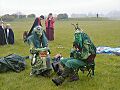
The May King and Queen at Thornborough Central Henge, during the Beltane festival in 2005
