Thorpe Cloud facts for kids
Quick facts for kids Thorpe Cloud |
|
|---|---|

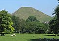
Thorpe Cloud from Dovedale, with stepping stones
|
|
| Highest point | |
| Elevation | 287 m (942 ft) |
| Prominence | 79 m (259 ft) |
| Geography | |

Thorpe Cloud
Location in Derbyshire
|
|
| Location | Derbyshire, England |
| Parent range | Peak District |
| OS grid | SK151510 |
| Topo map | OS Landranger 119 |
Thorpe Cloud is a cool, isolated hill located in England. It sits right on the border between Derbyshire and Staffordshire. This hill is a type of limestone formation called a "reef knoll." It's found at the southern end of a beautiful valley called Dovedale.
Thorpe Cloud is very popular with people who visit the area for a day out. It offers amazing views! From the top, you can look north up the Dovedale valley or south across the flat lands of the Midlands.
Contents
Who Owns Thorpe Cloud?
Just like many other parts of Dovedale, including Bunster Hill across the river, Thorpe Cloud is owned by the National Trust. The National Trust is a charity that looks after special places in England, Wales, and Northern Ireland. They bought these Dovedale properties in 1934 to protect them.
The Mysterious Double Sunset
In 1997, a writer named Jeff Kent made an interesting discovery. He found that you could see a "double sunset" when looking at Thorpe Cloud from a nearby spot called Lin Dale. Two years later, in 1999, a photographer named Chris Doherty managed to capture this amazing event on camera for the first time.
This double sunset happens around the summer solstice, which is the longest day of the year. If the weather is good, you can see the sun set on the very top of Thorpe Cloud. Then, it briefly reappears from the hill's steep northern side before setting for a second and final time shortly after. It's a really unique sight! Jeff Kent wrote all about this special event in his book, The Mysterious Double Sunset.
Thorpe Cloud in Movies
Thorpe Cloud and the Dovedale area were used as filming locations for the 2010 movie Robin Hood. This film starred the actor Russell Crowe. If you watch the movie, you can clearly spot Thorpe Cloud in several scenes towards the end of the film. It's pretty cool to see a real-life landmark in a big movie!
Other Uses for Thorpe Cloud
Besides being a popular spot for hikers and movie filming, Thorpe Cloud also has a rifle range. This range is used by local and national shooting clubs for practice and competitions.
-
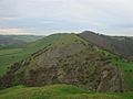
View from on the top of Thorpe Cloud looking towards Bunster Hill
-
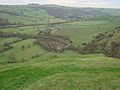
From Thorpe Cloud looking to the left of Bunster Hill with the Car Park in the middle
-