Timnath, Colorado facts for kids
Quick facts for kids
Timnath, Colorado
|
|
|---|---|

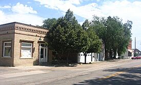
"Old Town Timnath" in 2005. Structures, from left to right (north to south) are the town hall, fire station, and an empty storefront.
|
|

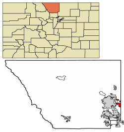
Location of Timnath in Larimer County, Colorado
|
|
| Country | United States |
| State | Colorado |
| County | Larimer |
| Settled | 1869 |
| Established | 1882 |
| Incorporated | July 6, 1920 |
| Named for | Biblical city of Timnath |
| Government | |
| • Type | Home Rule Town |
| Area | |
| • Total | 7.345 sq mi (19.023 km2) |
| • Land | 7.308 sq mi (18.928 km2) |
| • Water | 0.037 sq mi (0.095 km2) |
| Elevation | 4,869 ft (1,484 m) |
| Population
(2020)
|
|
| • Total | 6,487 |
| • Estimate
(2023)
|
9,991 |
| • Density | 1,279.0/sq mi (493.7/km2) |
| Time zone | UTC–7 (Mountain (MST)) |
| • Summer (DST) | UTC–6 (MDT) |
| ZIP Codes |
80547
|
| Area code(s) | 970 |
| FIPS code | 08-77510 |
| GNIS feature ID | 0180510 |
| Sales tax | 6.7% |
The Town of Timnath is a small town in Larimer County, Colorado, United States. It was founded in 1882. Timnath started as a farming community. It is located southeast of Fort Collins, Colorado, near the Cache la Poudre River.
Farmers in Timnath used to grow crops like potatoes, alfalfa, and sugar beets. They also raised cattle. In recent years, Timnath has grown a lot. It is now one of the fastest-growing towns in Colorado. In 2020, about 6,487 people lived there. By 2023, the population was estimated to be around 9,991.
Contents
What Timnath Looks Like
Timnath has a main street called County Road 5. Along this street, you can find an elementary school that is part of the Poudre School District. There is also a modern post office and some older, historic buildings. Most of the homes in Timnath are single-family houses. Another elementary school, Bethke Elementary, is located a few miles away.
Timnath's History
People first settled in the Timnath area in 1869. The very first schoolhouse, called "Fairview," was built that same year. By 1880, the community needed a bigger school, so a new "Fairview" school was built. This school also served as a meeting place for the Presbyterian Church.
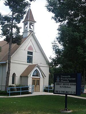
A big change happened in 1882 when the Greeley, Salt Lake and Pacific Railroad arrived. This railroad connected Greeley and Fort Collins, making it easier for people and goods to travel. The next year, a Presbyterian church was officially started in Timnath. The church building you see on Main Street today dates back to that time.
A post office opened in 1884. The local Presbyterian minister, Charles A. Taylor, was in charge of it. He chose the name "Timnath" for the town. He got the name from a story in the Book of Judges in the Bible. It was the place where Samson went to find a wife.
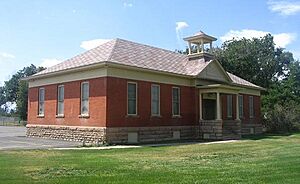
In 1900, the second school building became too old. A new one was built, and the name "Fairview" was no longer used. This 1900 building is still standing today next to the current elementary school. A larger school was built in 1918. It burned down in 1935 but was rebuilt the next year. In 1960, the Timnath school district joined with the Fort Collins district.
During World War II, Japan sent Fu-Go balloon bombs across the Pacific Ocean to the U.S. One of these bombs landed and exploded in a field in Timnath.
Where Timnath Is Located
Timnath is located at coordinates 40° 31' 44.94" N, 104° 59' 6.91" W.
The town covers a total area of about 7.345 square miles (19.023 square kilometers). Most of this area is land, with a small amount of water.
The old downtown area is along County Road 5. This road runs north and south, parallel to Interstate 25. Since the year 2000, Timnath has grown. It has added more land to the east and southeast. There has been a lot of new business development along County Road 38, also known as Harmony Road. Much of the land in Timnath's growth area is for homes or farms. There are also plans for open spaces and parks, especially near the Poudre River and Timnath Reservoir.
Timnath's Population
| Historical population | |||
|---|---|---|---|
| Census | Pop. | %± | |
| 1930 | 169 | — | |
| 1940 | 147 | −13.0% | |
| 1950 | 177 | 20.4% | |
| 1960 | 150 | −15.3% | |
| 1970 | 177 | 18.0% | |
| 1980 | 185 | 4.5% | |
| 1990 | 190 | 2.7% | |
| 2000 | 223 | 17.4% | |
| 2010 | 625 | 180.3% | |
| 2020 | 6,487 | 937.9% | |
| 2023 (est.) | 9,991 | 1,498.6% | |
| U.S. Decennial Census 2020 Census |
|||
Population in 2020
| Race | Number | Percent |
|---|---|---|
| White (NH) | 5,271 | 81.3% |
| Black or African American (NH) | 39 | 0.6% |
| Native American or Alaska Native (NH) | 12 | 0.2% |
| Asian (NH) | 299 | 4.6% |
| Pacific Islander (NH) | 1 | 0.0% |
| Some Other Race (NH) | 38 | 0.6% |
| Mixed/Multi-Racial (NH) | 288 | 4.4% |
| Hispanic or Latino | 539 | 8.3% |
| Total | 6,487 | 100.00% |
According to the 2020 census, Timnath had 6,487 people living there. There were 2,002 households and 1,814 families. The town had about 988 people per square mile (381 people per square kilometer). There were 2,213 housing units.
Most of the people in Timnath were White (83.8%). About 4.7% were Asian, and 0.6% were African American. About 8.3% of the population were Hispanic or Latino (of any race).
About 33.2% of the people were under 18 years old. About 6.8% were under 5 years old. And 14.5% were 65 years old or older.
Timnath has grown very quickly in recent years. It was the fastest-growing town in Colorado in 2022. Its population increased by 19.2% that year. Since 2020, its population has grown by 44.0%.
Notable People
- Jean Bethke Elshtain, a political philosopher.
See also
 In Spanish: Timnath (Colorado) para niños


