Tirso (river) facts for kids
Quick facts for kids Tirso |
|
| River | |
|
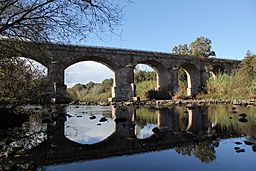
Fordongianus - bridge over the Tirso river
|
|
| Country | Italy |
|---|---|
| Region | Sardinia |
| Provinces | Nuoro, Sassari, Oristano |
| Tributaries | |
| - left | Taloro, Mannu |
| City | Oristano |
| Source | Buddusò plateau |
| - location | Bitti, Nuoro, Italy |
| - elevation | 985 m (3,232 ft) |
| Mouth | Mediterranean Sea |
| - location | Golf of Oristano, Oristano, Italy |
| - elevation | 0 m (0 ft) |
| - coordinates | 39°53′6″N 8°32′26″E / 39.88500°N 8.54056°E |
| Length | 159 km (99 mi) |
| Basin | 3,376 km² (1,303 sq mi) |
| Discharge | |
| - average | 16.6 m³/s (586 cu ft/s) |
The Tirso (called Tirsu in the Sardinian language) is the most important river in Sardinia, Italy. It is the longest river on the island. It also has the biggest drainage basin, which is the area of land where all the water flows into this river.
The Tirso River starts high up in the mountains in the middle of Sardinia. It then flows all the way to the Mediterranean Sea.
Contents
River's Name
In the past, people in Sardinia called this river riu de Aristanis, which means "river of Oristano." Sometimes, they simply called it riu Mannu, meaning "the big river."
The name Tirso became common more recently. It comes from the ancient name "Thyrsos," which was used by a Greek geographer named Ptolemy a long time ago.
River's Journey
The Tirso River is about 159 kilometers (99 miles) long. Its drainage basin covers a large area of about 3,376 square kilometers (1,303 square miles). This means a lot of land drains its water into the Tirso.
The amount of water flowing in the river, called its discharge, changes with the seasons. On average, about 16.6 cubic meters (586 cubic feet) of water flow through it every second. However, during the summer, the water level can become very low.
Where the River Starts
The Tirso River begins in an area called the Buddusò plateau. It starts on the side of a hill called Punta Pianedda. This is about 985 meters (3,232 feet) above sea level. The starting point is north of a town called Bitti. From here, the river flows towards the southwest.
Where the River Ends
After traveling about 150 kilometers (93 miles), the Tirso River reaches the Mediterranean Sea. It flows into the Gulf of Oristano, which is part of the Sea of Sardinia. The river enters the sea about 6 kilometers (4 miles) north of the city of Oristano.
Omodeo Lake
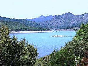
Along its path, the Tirso River forms a large artificial lake called "Omodeo lake." This lake was created by humans. It is about 20 kilometers (12 miles) long and 3 kilometers (2 miles) wide. Omodeo lake is one of the biggest artificial lakes in all of Italy.
Main Rivers Joining the Tirso
Most of the smaller rivers that flow into the Tirso are just small streams. However, there are two main ones:
- Taloro: This is the most important river that joins the Tirso. It is about 67.61 kilometers (42 miles) long. Its drainage basin covers about 495.02 square kilometers (191 square miles).
- Massari: This is the second largest river that flows into the Tirso. It is about 37.78 kilometers (23 miles) long. Its drainage basin is about 833.73 square kilometers (322 square miles).
Both the Taloro and Massari rivers join the Tirso from its left side.
Related Information
See also
 In Spanish: Río Tirso para niños


