
Tonopah, Arizona facts for kids
Quick facts for kids
Tonopah, Arizona
|
|
|---|---|

Tonopah Post Office
|
|

Location in Maricopa County, Arizona
|
|

Tonopah, Arizona
Location in Arizona

Tonopah, Arizona
Location in the United States
|
|
| Country | United States |
| State | |
| County | Maricopa |
| Established | 1929 |
| Area | |
| • Total | 1.37 sq mi (3.54 km2) |
| • Land | 1.37 sq mi (3.54 km2) |
| • Water | 0.00 sq mi (0.00 km2) |
| Elevation | 1,490 ft (450 m) |
| Population
(2020)
|
|
| • Total | 23 |
| • Density | 16.84/sq mi (6.50/km2) |
| Time zone | UTC-7 (MST) |
| • Summer (DST) | N/A |
| ZIP code |
85354
|
| Area code(s) | 623 and 928 |
| FIPS code | 04-74540 |
Tonopah is a small community in western Maricopa County, Arizona, United States. It is located about 52 miles (84 km) west of downtown Phoenix, right off Interstate 10.
Tonopah is known for being close to the Palo Verde Nuclear Generating Station. This is the largest power plant in the entire country. It produces a lot of electricity for many homes and businesses.
In 2020, only 23 people lived in Tonopah. This number was lower than in 2010, when 60 people lived there. Before it was called Tonopah, the area was known as "Lone Peak."
Tonopah is in the Tonopah Desert. Many of the wells here have warm water, usually between 70°F and 95°F. Some wells even have hot water, from 110°F to 120°F.
Long ago, different groups of people lived in this area. These included the Hohokam, Patayan, and Yavapai cultures. They gathered resources from the desert here.
Contents
Tonopah's Population
| Historical population | |||
|---|---|---|---|
| Census | Pop. | %± | |
| 2010 | 60 | — | |
| 2020 | 23 | −61.7% | |
| U.S. Decennial Census | |||
In 2010, there were 60 people living in Tonopah. By 2020, the population had decreased to 23 people. This means there were about 1.13 people per square mile in 2010.
Local Schools
Tonopah has a few schools for students in the area:
- Crossroads Academy
- Ruth Fisher Middle School
- Tonopah Valley High School
- Winters Well Elementary School
Efforts to Become a Town
For a while, people in Tonopah wanted their community to become an official town. This process is called "incorporation." If a community incorporates, it can have its own local government and make its own rules.
Why Tonopah Wanted to Incorporate
In 2009, a group called Tonopah United for Our Future (TUFF) started working on this idea. They wanted Tonopah to become a real town.
Challenges from Buckeye
However, there was a problem. The nearby town of Buckeye did not agree with Tonopah's plan. State law says that a new town cannot be formed too close to an existing town without their permission. Buckeye's leaders were worried that the proposed new town of Tonopah would include land that Buckeye wanted to use in the future.
Reasons Against Incorporation
Many residents also had concerns. They thought the proposed new town was too big. It would cover about 100 square miles (259 square kilometers). This would make it one of the largest towns in Arizona by area, even though it would only have about 6,000 people. Some residents also worried that becoming a town would mean higher taxes to pay for a new government.
The Vote and Future Plans
On March 10, 2009, people voted on the plan. Most people voted against it, with 523 votes saying no and 356 votes saying yes. So, Tonopah did not become a town at that time.
However, in 2023, a new group called The Tonopah Incorporation Committee started the process again. They hope that Tonopah will become an official town by Fall 2024. If this happens, the new town is expected to have a population of about 4,300 people.
Belmont: A Future Smart City?
In November 2017, news came out that a company connected to billionaire Bill Gates bought a lot of land near Tonopah. They bought 24,800 acres (100 square kilometers) for $80 million. The company announced plans to build a "smart city" called Belmont on this land. A smart city uses technology to make life better for its residents. As of 2023, no construction has started on Belmont.
Tonopah's Climate
Tonopah has a desert climate. Here is some information about the weather:
| Climate data for Tonopah, Arizona (Elevation 1,300ft) | |||||||||||||
|---|---|---|---|---|---|---|---|---|---|---|---|---|---|
| Month | Jan | Feb | Mar | Apr | May | Jun | Jul | Aug | Sep | Oct | Nov | Dec | Year |
| Record high °F (°C) | 82 (28) |
91 (33) |
98 (37) |
105 (41) |
115 (46) |
121 (49) |
119 (48) |
117 (47) |
113 (45) |
104 (40) |
94 (34) |
87 (31) |
121 (49) |
| Mean daily maximum °F (°C) | 65.7 (18.7) |
70.7 (21.5) |
76.0 (24.4) |
85.5 (29.7) |
94.4 (34.7) |
103.8 (39.9) |
106.8 (41.6) |
104.5 (40.3) |
99.2 (37.3) |
88.3 (31.3) |
75.4 (24.1) |
66.2 (19.0) |
86.4 (30.2) |
| Mean daily minimum °F (°C) | 36.8 (2.7) |
40.1 (4.5) |
43.4 (6.3) |
50.5 (10.3) |
59.7 (15.4) |
67.9 (19.9) |
77.0 (25.0) |
75.6 (24.2) |
67.1 (19.5) |
55.1 (12.8) |
43.2 (6.2) |
36.5 (2.5) |
54.4 (12.4) |
| Record low °F (°C) | 17 (−8) |
22 (−6) |
23 (−5) |
26 (−3) |
41 (5) |
49 (9) |
60 (16) |
54 (12) |
42 (6) |
35 (2) |
16 (−9) |
14 (−10) |
14 (−10) |
| Average precipitation inches (mm) | 1.08 (27) |
0.88 (22) |
0.75 (19) |
0.27 (6.9) |
0.05 (1.3) |
0.06 (1.5) |
0.62 (16) |
1.18 (30) |
0.57 (14) |
0.44 (11) |
0.61 (15) |
1.13 (29) |
7.63 (194) |
| Average snowfall inches (cm) | 0 (0) |
0 (0) |
0 (0) |
0 (0) |
0 (0) |
0 (0) |
0 (0) |
0 (0) |
0 (0) |
0 (0) |
0 (0) |
0 (0) |
0 (0) |
| Source: The Western Regional Climate Center | |||||||||||||
Tonopah in Popular Culture
The song "Willin'" by Lowell George of the band Little Feat mentions Tonopah. The song is about a truck driver traveling across the country. It goes:
It's not clear if the song refers to Tonopah, Arizona, or Tonopah, Nevada.
Images for kids
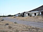
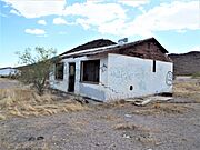
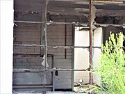
Here are some pictures related to Tonopah, showing its history and interesting places:
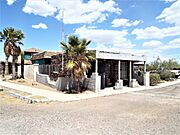
- The ruins of the house of John Beauchamp, who was an important landowner and Tonopah's first postmaster. His house was built in 1920.
- The former Saguaro Sanitarium, which is now the Motel Saguaro Mineral Wells. The first governor of Arizona, George W. P. Hunt, attended its opening ceremony in 1934.
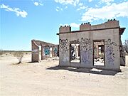
- Ruins from the Tonopah-Belmont mine workers camp.

-
John Beauchamp House
-
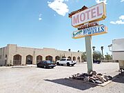
Motel Saguaro Mineral Wells
-
Motel Saguaro Mineral Wells office
-
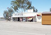
Tonopah Ranch and Land Office
-
Tonopah-Belmont mine ruins
-
Tonopah-Belmont mine ruins
-
Tonopah-Belmont mine ruins
-
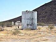
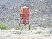
Tonopah Ruins water tank
-
Tonopah-Belmont mine ruins
-
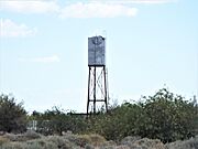
Tonopah water tower


See also
 In Spanish: Tonopah (Arizona) para niños
