
Toobeah facts for kids
Quick facts for kids ToobeahQueensland |
|||||||||||||||
|---|---|---|---|---|---|---|---|---|---|---|---|---|---|---|---|

Eastern entrance on the Barwon Highway (2021).
|
|||||||||||||||

Toobeah
Location in Queensland
|
|||||||||||||||
| Population | 149 (2021 census) | ||||||||||||||
| • Density | 0.1324/km2 (0.343/sq mi) | ||||||||||||||
| Postcode(s) | 4498 | ||||||||||||||
| Area | 1,125.5 km2 (434.6 sq mi) | ||||||||||||||
| Time zone | AEST (UTC+10:00) | ||||||||||||||
| Location |
|
||||||||||||||
| LGA(s) | Goondiwindi Region | ||||||||||||||
| State electorate(s) | Southern Downs | ||||||||||||||
| Federal Division(s) | Maranoa | ||||||||||||||
|
|||||||||||||||
Toobeah, pronounced 'two beer', is a small country town in Queensland, Australia. It is a rural locality within the Goondiwindi Region. This area is located right on the border between Queensland and New South Wales. In 2021, the town and its surrounding area had a population of 149 people.
Contents
Where is Toobeah Located?
Toobeah is situated in the Darling Downs region of Queensland. The town is found along the Barwon Highway. It is about 389 kilometres (or 242 miles) south-west of Brisbane, which is the capital city of Queensland.
A Look at Toobeah's History
How Toobeah Got Its Name
The town of Toobeah gets its name from the Toobeah railway station. This railway station was built in 1910 as part of the South Western railway line.
People believe the name "Toobeah" comes from an Aboriginal word. This word likely means 'to point'. This might be because there was a signpost at the road junction where the railway station was built.
Early Schools in Toobeah
A school called Toobeah Provisional School first opened its doors on 12 October 1914. Just a short time later, on 1 December 1914, it became Toobeah State School.
However, this school eventually closed down on 30 April 1964. It was located on the northern corner of the Barwon Highway and Minnel Road.
Education Opportunities
Toobeah itself does not have any schools right in the town. Students living in Toobeah usually travel to nearby towns for their schooling.
Primary School Options
For primary school, children can attend schools in neighbouring areas. These include:
- Bungunya State School, located to the west in Bungunya.
- Kioma State School, found to the north-west in Kioma.
- Lundavra State School, situated to the north in Lundavra.
- Goondiwindi State School, which is to the east in Goondiwindi.
Secondary School Options
The closest government high school for older students is Goondiwindi State High School in Goondiwindi. However, if you live in the northern or western parts of Toobeah, it might be too far to travel to Goondiwindi every day. In these cases, students might use distance education (learning from home) or attend a boarding school.
What Can You Find in Toobeah?
Even though it's a small town, Toobeah has a few useful places. You can find the Coronation Hotel, which is a place to stay and eat. There is also a general store where you can buy everyday items.
-
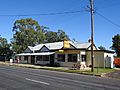
Toobeah hotel motel (2021).

