
Bungunya, Queensland facts for kids
Quick facts for kids BungunyaQueensland |
|||||||||||||||
|---|---|---|---|---|---|---|---|---|---|---|---|---|---|---|---|

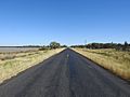
Barwon Highway on the western approach to the locale (2021).
|
|||||||||||||||

Bungunya
Location in Queensland
|
|||||||||||||||
| Population | 62 (2021 census) | ||||||||||||||
| • Density | 0.1379/km2 (0.357/sq mi) | ||||||||||||||
| Postcode(s) | 4494 | ||||||||||||||
| Area | 449.5 km2 (173.6 sq mi) | ||||||||||||||
| Time zone | AEST (UTC+10:00) | ||||||||||||||
| Location |
|
||||||||||||||
| LGA(s) | Goondiwindi Region | ||||||||||||||
| State electorate(s) | Southern Downs | ||||||||||||||
| Federal Division(s) | Maranoa | ||||||||||||||
|
|||||||||||||||
Bungunya is a small country town. It is also a locality in the Goondiwindi Region of Queensland, Australia. This area is right on the border between Queensland and New South Wales. In 2021, only 62 people lived in Bungunya.
Contents
Where is Bungunya?
Bungunya is located just north of the Macintyre River. This river forms the border between Queensland and New South Wales. The Weir River also flows through the northern part of Bungunya. Many other creeks flow through the area too. All these rivers and creeks eventually join the Barwon River in New South Wales.
The town itself is in the middle of the locality. The Barwon Highway runs through the area, just north of the town. This highway connects St George and Goondiwindi. Another road, the Meandarra – Talwood Road, goes north from the highway.
The South Western railway line also passes through Bungunya. It runs south of the town. Bungunya has its own train station, called Bungunya railway station. There was once another station, Welltown railway station, but it is no longer used.
The land around Bungunya is very flat. It is about 180 metres above sea level. Most of the land is used for farming.
A Look at Bungunya's Past
The name Bungunya might come from an Aboriginal word. It is thought to mean a high or safe place to live. We don't know which Aboriginal language it comes from. It might even be a name brought from Victoria.
The Gamilaraay people are traditional owners of this land. Their language region covers parts of South-West Queensland and North-West New South Wales. This includes towns like Dirranbandi, Thallon, Talwood, and Bungunya. It also reaches into New South Wales.
Bungunya Provisional School first opened in 1916. At first, it shared a teacher with another school. In 1918, it became a full-time school. Soon after, it became a state school.
Bungunya used to be a busy place for trains. Thousands of bales of wool were sent from local sheep stations by train. This happened after the shearing season.
How Many People Live Here?
The number of people living in Bungunya has changed over the years.
- In 2011, there were 189 people living in Bungunya.
- In 2016, the population was 75 people.
- In 2021, the population was 62 people.
Learning in Bungunya
Bungunya State School is a government primary school. It teaches students from Prep to Year 6. The school is located on George Street. In 2017, 22 students were enrolled there. In 2023, there were 17 students. As of 2024, the school was open but had no students. This means it was not running classes.
There are no high schools in Bungunya or very close by. Students who want to continue their education can choose distance education. This means learning from home. Another option is to go to a boarding school.
Gallery
-
Barwon Highway westbound, east of Bungunya turn-off (2021).
-
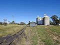
Railway siding and silos (2021).
-
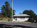
Post office building, Main Street (2021).


