
Boomi, New South Wales facts for kids
Quick facts for kids BoomiNew South Wales |
|
|---|---|

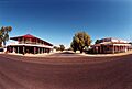
Pioneer Hotel and an abandoned store
|
|

Boomi
Location in New South Wales
|
|
| Population | 201 (2016 census) |
| Postcode(s) | 2405 |
| Elevation | 184 m (604 ft) |
| Location | |
| LGA(s) | Moree Plains Shire |
| State electorate(s) | Northern Tablelands |
| Federal Division(s) | Parkes |
Boomi is a small town in north western New South Wales, Australia. It's part of the Moree Plains Shire local government area. The town is about 728 kilometres (452 miles) north west of Sydney. Boomi sits right on the MacIntyre River, close to the border with Queensland. It is west of Goondiwindi in Queensland and north of Moree in New South Wales. In 2016, Boomi and the farms around it had a population of about 200 people.
Boomi's Past
The land around Boomi has a rich history. It is part of the traditional country of the Gamilaraay people. The Gamilaraay (also known as Gamilaroi or Kamilaroi) language is an Aboriginal language. It comes from South-West Queensland and North-West New South Wales. The Gamilaraay language area includes towns like Dirranbandi, Thallon, and Bungunya. It also covers border towns like Mungindi and Boomi. Further south, it reaches Moree, Tamworth, and Coonabarabran in New South Wales.
Weather in Boomi
The weather in Boomi can change a lot. The area gets about 22 inches (550 millimetres) of rain each year. However, the amount of rain can be very different from one year to the next.
Summers are long and hot. Temperatures can reach up to 43°C (109°F). Summer storms often bring rain, which can sometimes cause floods. Winters are cooler, with light rain. Nights can be cold, dropping to 0°C (32°F). This causes frequent frosts. But the days in winter are usually pleasant. Spring and autumn seasons are quite short in Boomi.
Land and Nature
The area around Boomi is very flat. People often call it the "black soil plains." However, the soil is actually a mix of black, grey, and brown loam. You can also find sandy ridges.
This region often experiences floods. The McIntyre River drops only about 19 centimetres (7.5 inches) per kilometre. It flows slowly between Goondiwindi and Mungindi. If there's a flood peak in Goondiwindi, it will reach the Kanowna gauge about a week later. This gauge is 113 kilometres (70 miles) downstream. The McIntyre River has many smaller streams, called tributaries. Floods and water flows help the rich land. This land is great for grazing animals and farming.
Long ago, the plains had light forests. These forests had trees like gum, coolibah, and cypress pine. Early settlers used these trees for building houses and fences. Today, the region is famous for its good merino sheep. These sheep produce fine wool. The area also has quality beef cattle. Farmers have started growing crops too. They now have large farms that produce top-grade wheat, oats, and barley.
Boomi is home to lots of wildlife. You can see pigs, kangaroos, and emus. Many different kinds of birds live here too. The rivers are perfect for fishing. You can catch fish like cod and yellow belly.
Boomi's Rivers
Rivers and their smaller streams are very important to the Boomi area. The McIntyre River system starts in the Great Dividing Range. This is a mountain range between Guyra and Stanthorpe. The river then flows north west towards Goondiwindi. After that, it turns west. The Boomi region is on the New South Wales side of the McIntyre River. It's located between Goondiwindi, Queensland, and Mungindi. Mungindi is about 170 kilometres (105 miles) downstream and sits on the border. In the past, the MacIntyre River was sometimes called the Barwon River. Now, the name Barwon River is used after it joins with the Weir River.
The Weir River starts in south east Queensland. It flows next to the Barwon River for a short distance. This is north of the Boomi region. During floods, water from the Weir River can spill into the Barwon River. Eventually, the Weir River joins the Barwon River as they flow towards Mungindi.
The Gnoura Gnoura Creek branches off from the Boomi River at Boronga. It flows west before joining the Barwon River at a place called Barra. The Boomi River itself is a tributary of the McIntyre and Barwon River system. It winds its way downstream. Then, it flows back into the Barwon River south of Mungindi.
The Whalan Creek starts near Boggabilla, from the McIntyre River. It flows as a stream that sometimes forms into low, wet areas. Later, it becomes a larger waterway. It then flows into the Boomi River, just before the Boomi River meets the Barwon River.
Within these river systems, there are many lagoons, channels, and gullies. These may seem small. However, they carry a lot of water during floods. This shows that Boomi is truly a river region. Most of the time, these streams provide water for animals and homes. Some farms also use water from bore drains or dams.
Images for kids
-
Pioneer Hotel and an abandoned store
