Topgallant Islands facts for kids
| Geography | |
|---|---|
| Location | Great Australian Bight |
| Coordinates | 33°42′55″S 134°36′54″E / 33.71536°S 134.61487°E |
| Administration | |
|
Australia
|
|
| Demographics | |
| Population | 0 |
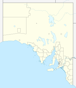
The Topgallant Islands are a group of islands in South Australia. They are found in the Investigator Group, about 22 kilometers (14 miles) southwest of Cape Finniss. This cape is on the west coast of the Eyre Peninsula.
Explorer Matthew Flinders discovered and named these islands on February 13, 1802. Since the 1960s, the Topgallant Islands have been a protected area. In 2011, they became part of the Investigator Group Wilderness Protection Area.
Contents
What Are the Topgallant Islands Like?
The Topgallant Islands are located about 22 kilometers (14 miles) southwest of Cape Finniss. This is on the west coast of the Eyre Peninsula in South Australia. They are also about 27 kilometers (17 miles) west of the town of Elliston.
The group includes one small islet and several bare rocks. Some sources say there are seven rocks. These rocks stretch out from the islet in a line for about 1.85 kilometers (1.15 miles) to the southeast.
The main islet is about 20 hectares (49 acres) in size. It is surrounded by tall cliffs, which are about 75 meters (246 feet) high. The top of the islet is rounded and reaches 101 meters (331 feet) above sea level. The rock furthest to the south looks like a sharp pyramid and is 55 meters (180 feet) tall.
The name of the island group can be spelled in a few ways. Matthew Flinders called them "Topgallant Isles." Other names include Topgallant Islands, Top-gallant Islands, Top-Gallant Isles, and Top Gallant Isles.
It is very hard to reach Topgallant Island by boat. This is because of deep ocean waves, steep shores, and rocky cliffs. In 1980, a survey team had to use a helicopter to land on the islet.
How the Islands Were Formed
The Topgallant Islands were created about 8,750 years ago. This happened when sea levels rose at the start of the Holocene period.
The islands are made of calcarenite rock layers. These layers sit on top of an older granite ridge. This granite ridge is now underwater. Over time, ocean waves have worn away a lot of the rock.
The Topgallant Islands are part of a hidden reef system under the water. This reef system stretches for about 1.85 kilometers (1.15 miles). It goes from the islet in the west to the east of the southernmost rock. There are also "sunken rocks" that extend about 0.9 kilometers (0.56 miles) southwest of the islet. The water gets as deep as 30 meters (98 feet) within 3 kilometers (1.9 miles) to the west.
Plants and Animals Living Here
Plants on the Islands
Plants mostly grow on the top of the islet. This is where the soil is deep enough for shrubs to grow. Some plants also grow on two of the larger rocks.
A survey in 1980 found four main types of plant groups. These included low shrubland areas. Some were dominated by chenopod plants, while others had nitre bush or pointed twinleaf.
Twenty different plant species were found during the 1980 survey. This included two plants that are not native to the area and can spread easily: African boxthorn and common iceplant.
Animals Living Here
Many different animals have been seen on the Topgallant Islands. These include marbled geckos, which are a type of lizard.
Many bird species also live on or visit the islands. Some of these birds are:
- Richard's pipit
- White-faced heron
- Australian kestrel
- White-bellied sea-eagle
- Welcome swallow
- Silver gull
- Rock parrot
- White-faced storm petrel
- Short-tailed shearwater
- Common starling
A Look at the Islands' History
European Discovery
Matthew Flinders discovered the island group on Saturday, February 13, 1802. He named them "Topgallant Isles" because they looked like "ships under sail." On the same day, Flinders also included them as part of the larger Investigator Group.
Protecting the Topgallant Islands
The Topgallant Islands first became a protected area in the 1960s. This happened under the Fauna Conservation Act 1964. They were declared a fauna reserve on either September 1, 1966, or March 16, 1967.
Later, in 1972, the island group and other nearby islands became part of the Investigator Group Conservation Park. This was under the National Parks and Wildlife Act 1972.
On August 25, 2011, the Topgallant Islands were taken out of the Conservation Park. They then became part of the Investigator Group Wilderness Protection Area. This new area helps protect the islands even more.
Since 2012, the waters around the Topgallant Islands have also been protected. They are now part of a special sanctuary zone within the Investigator Marine Park. This helps protect the marine life around the islands.
 | Chris Smalls |
 | Fred Hampton |
 | Ralph Abernathy |


