
Tornado, West Virginia facts for kids
Quick facts for kids
Tornado, West Virginia
|
|
|---|---|

Location in Kanawha County and state of West Virginia.
|
|
| Country | United States |
| State | West Virginia |
| County | Kanawha |
| Area | |
| • Total | 3.67 sq mi (9.51 km2) |
| • Land | 3.59 sq mi (9.29 km2) |
| • Water | 0.09 sq mi (0.23 km2) |
| Elevation | 614 ft (187 m) |
| Population
(2020)
|
|
| • Total | 1,081 |
| • Density | 294.40/sq mi (113.67/km2) |
| Time zone | UTC-5 (Eastern (EST)) |
| • Summer (DST) | UTC-4 (EDT) |
| ZIP Codes |
25177, 25202
|
| Area code(s) | 304/681 |
| GNIS feature ID | 1555859 |
| FIPS code | 54-82180 |

Tornado, also known as Upper Falls, is a small community in Kanawha County, West Virginia, United States. It is called a census-designated place (CDP) because it's an area the government tracks for population numbers.
The name of this community has changed a few times over the years. The United States Postal Service first called its post office "Upper Falls of Coal" in 1851. Later, in 1881, it became the "Tornado Post Office." Even today, mail can be sent to either Tornado or Upper Falls. The United States Board on Geographic Names officially changed the name between Tornado and Upper Falls several times. For example, it was Tornado in 1980, then Upper Falls in 2010, and back to Tornado in 2013. The United States Census Bureau also changed how it counted the area, calling it "Tornado CDP" in 1990, "Upper Falls CDP" in 2010, and then "Tornado CDP" again for 2020.
In 2020, about 1,081 people lived in Tornado. The community gets its historical name from the beautiful waterfalls, called the Upper Falls, on the nearby Coal River.
Contents
Exploring Tornado's Location
Tornado is located in West Virginia at specific geographic coordinates. It covers an area of about 9.51 square kilometers (about 3.67 square miles). Most of this area is land, with a small part being water.
The famous Upper Falls of the Coal River, which gave the community its name, are also located nearby.
People and Population in Tornado
The Tornado community today is smaller than it was in 2010 when it was called Upper Falls. In 2020, 1,081 people lived here. The average household income was about $67,564. Many residents, about 18.7%, have a college degree or higher. Most adults, about 55.9%, are employed. There are 446 households and 441 housing units in the area.
A Look Back at 2010 Population
In 2010, when the area was known as the Upper Falls CDP, it was much larger. It had a population of 3,701 people and covered about 17.18 square miles (44.5 square kilometers). This made it the largest CDP in West Virginia by size at that time.
Most people living there in 2010 were White (96.8%). About 33.6% of households had children under 18. The average age of people in the community was 41 years old.
Tornado's Rich History
The history of Tornado, or Upper Falls, goes back a long way.
Early Discoveries and Settlers
In 1742, an explorer named John Peter Salling discovered the Upper Falls of the Coal River. He and his friends were exploring the land for the state of Virginia. During their trip, they also found coal along the riverbanks.
After the American Revolutionary War, European settlers started moving into the area. Around 1800, Joseph Thomas built a gristmill at the Upper Falls. This mill helped grind grain and stayed open until the 1930s.
River Transportation and Coal
Around 1830, people started floating timber down the Coal River to Saint Albans. They also found a lot of valuable cannel coal in the area. However, logs and boats full of coal could only travel down the river when the water was high enough to pass over the Upper Falls and Lower Falls.
To make the Coal River easier to travel, a system of wooden locks and dams was built in the 1850s. This allowed steamboats to carry coal, coal oil, and timber both up and down the river. The Upper Falls was home to the Upper Falls Lock and Dam. Edward Kenna, who also had a sawmill there, was the lockmaster. His son, John E. Kenna, later became a U.S. senator for West Virginia. The American Civil War and floods damaged the system, and steamboat travel ended in 1881.
The Arrival of the Railroad
After many attempts, a rail line was finally built along the Coal River between 1902 and 1904. This railroad brought a big economic boost to the region. The "Upper Falls Station" became a busy place with daily service for passengers and goods. While timber cutting mostly stopped in the 1920s, the rail line, now owned by CSX Transportation, still carries huge amounts of coal to markets around the world.
Growth After World War II
Many people moved to Tornado during and after World War II. They found jobs in defense and chemical factories in the Kanawha Valley. This brought prosperity to the community. Today, Tornado is a residential area and a place for recreation, close to the Charleston metropolitan area.
Post Offices Serving Tornado
The first post office in the area was called "Upper Falls of Coal" and opened in 1851. Later, in 1881, it was replaced by a post office named "Tornado."
Today, people in the area might use either "Tornado" or "Upper Falls" for their mail, depending on their ZIP Code. Both names are commonly used.
Other Names for Areas in Tornado
Besides Tornado and Upper Falls, some parts of the community have other names:
- Andrews Heights: This area is named after R. Carl Andrews, who was the mayor of Charleston from 1947 to 1950. Andrews Heights Elementary School is also named after him.
- Big Bend: This area is named for a large curve in the Coal River. The Big Bend Golf Course is located here.
Getting Around Tornado
Throughout its history, Tornado has relied on different ways to travel, including roads, trains, and the river.
Roads and Highways
Today, most people in Tornado travel by car on local highways.
The main roads include Coal River Road and Falls Creek Road. These roads connect Tornado to other areas and to Lincoln County.
Rail Transport
The Coal River subdivision is a major rail line owned by CSX Transportation. It runs next to the Coal River and is mainly used to transport coal from the southern West Virginia coalfields to different markets. There used to be a train station in the community called "Upper Falls Station."
River Travel
The Coal River is still considered a navigable waterway by the government. However, the old system of locks and dams from the 1800s, which allowed commercial boats to travel, no longer exists.
Learning Opportunities in Tornado
Here are some places for education in the community:
- Andrews Heights Elementary School, 7776 Coal River Road
- Humphreys After School Program, 7799 Coal River Road
Fun Things to Do in Tornado
There are several places for recreation in and around Tornado:
- Big Bend Golf Course, 151 Riverview Drive
- Coal River (great for outdoor activities)
- Meadowood Park, 292 Pettigrew Lane
- Mountaineer Radio Control Flying Club, 8004 Smith Creek Road
- Walhonde Trail
Churches in the Community
Here are some of the churches in Tornado:
- Browns Creek Church of God, 2550 Browns Creek Road
- Humphreys Memorial United Methodist Church, 7799 Coal River Road
- New Hope Baptist Church, 9414 Coal River Road
- Pleasant Hill Baptist Church, 7398 Smith Creek Road
- Riverview Freewill Baptist Church, 10603 Coal River Road
- Tornado Apostolic Church, 1100 Gore Addition Road
Images for kids
-
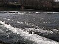
Upper Falls of Coal River, with Upper Falls Dam above and the historic lock in the foreground, viewed from Upper Falls Landing
See also
 In Spanish: Upper Falls (Virginia Occidental) para niños
