Trout Run (Shamokin Creek tributary) facts for kids
Quick facts for kids Trout Run |
|
|---|---|

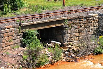
Mouth of Trout Run
|
|
| Physical characteristics | |
| Main source | Number Four Reservoir in Coal Township, Northumberland County, Pennsylvania between 880 and 900 feet (268 and 274 m) |
| River mouth | Shamokin Creek in Coal Township, Northumberland County, Pennsylvania 656 ft (200 m) 40°48′16″N 76°34′08″W / 40.80440°N 76.56884°W |
| Length | 1.4 mi (2.3 km) |
| Basin features | |
| Progression | Shamokin Creek → Susquehanna River → Chesapeake Bay |
| Basin size | 3.01 sq mi (7.8 km2) |
Trout Run is a small stream, also called a tributary, that flows into Shamokin Creek in Northumberland County, Pennsylvania, USA. It is about 1.4 miles (2.3 km) long. The stream runs through Coal Township. The area of land that drains into Trout Run, called its watershed, is about 3.01 square miles (7.79 km2).
Trout Run has very clean water. It flows through a valley between two mountains, Big Mountain and Little Mountain. A reservoir (a human-made lake) on the stream has been used to supply water. Trout Run is a special place for fish. It is known as a Coldwater Fishery and a Migratory Fishery. This means it is a good home for fish that like cold water and for fish that travel to different places.
Contents
Where Trout Run Flows
Trout Run starts in the Number Four Reservoir in Coal Township. From there, it flows west-southwest for a short distance. It moves through a wide, deep valley located between two ridges.
The stream then turns west-northwest for a little while. After that, it turns southwest. A bit further downstream, Trout Run meets and joins Shamokin Creek. This meeting point is about 20.48 miles (32.96 km) upstream from where Shamokin Creek ends.
Water Quality
Trout Run has very good water quality. The stream is not listed as "impaired." This means its water is healthy and clean. No part of Trout Run or its smaller connecting streams has been found to have water quality problems.
Land and Rocks Around the Stream
The land near where Trout Run joins Shamokin Creek is about 656 feet (200 m) above sea level. The place where Trout Run begins is higher up. It is between 880 and 900 feet (268 and 274 m) above sea level. Trout Run is considered a fairly small stream.
The area that drains into Trout Run is just north of a historic mining region. However, the stream itself is not affected by mining activities. Trout Run drains part of a valley called Brush Valley. This valley is found between Big Mountain and Little Mountain. The rocks in this valley are red shale. These rocks are part of something called the Mauch Chunk Formation.
There is a dam on Trout Run called the Trout Run Dam Number 4. As of 1980, this dam was in good condition.
Trout Run's Watershed
The watershed of Trout Run covers an area of about 3.01 square miles (7.79 km2). The entire stream is located within the United States Geological Survey map area known as Shamokin.
The watershed of Trout Run is in the middle part of the larger Shamokin Creek drainage area. It is shaped like a rectangle, being longer than it is wide. The community of Uniontown is located near where Trout Run flows into Shamokin Creek.
Most of the land around Trout Run is covered by forest. In the past, Trout Run was a source of water supply for the town of Shamokin. Today, it also provides water for a large government facility in Coal Township.
History of Trout Run
Trout Run was officially added to the Geographic Names Information System on August 2, 1979. This system keeps track of names and locations of places.
A dam called the No. 4 Dam has been on Trout Run since at least the early 1900s. Back then, the Shamokin Water Company owned it. A reservoir was built on the stream in the late 1800s to supply water. Water flowed by gravity through a large wooden pipe to the town of Shamokin.
However, Trout Run could not always provide enough water. So, in 1886, a pipe was built to connect the water from Roaring Creek to the beginning of Trout Run. This helped to bring more water to the area.
After Hurricane Eloise, a project was done to fix the stream's channel. This involved using 450 tons of riprap (large rocks) along 120 feet (37 m) of Trout Run.
In 2015, the land in the Trout Run watershed was considered for a new county building. However, some local groups, like the Brush Valley Preservation Association, did not agree with this idea. They had different plans for how the land should be used.
Animals and Plants
The area that drains into Trout Run is special for fish. It is known as a Coldwater Fishery and a Migratory Fishery. This means it supports fish that like cold water and fish that travel.
A small hatchery is located near the mouth of the stream. A group of local sports enthusiasts takes care of this hatchery. Trout Run has always been a good home for aquatic life (animals and plants that live in water). It continues to support many water-dwelling creatures today.
 | Leon Lynch |
 | Milton P. Webster |
 | Ferdinand Smith |

