
Shamokin Creek facts for kids
Quick facts for kids Shamokin Creek |
|
|---|---|

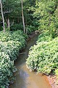
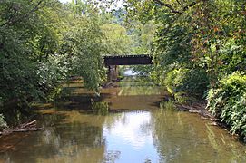
Shamokin Creek looking upstream in Shamokin, Pennsylvania
|
|
| Other name(s) | Great Shamokin Creek, Middle Branch Shamokin Creek |
| Physical characteristics | |
| Main source | eastern edge of Mount Carmel, Northumberland County, Pennsylvania |
| River mouth | Susquehanna River on the border between Upper Augusta Township, Northumberland County, Pennsylvania and Sunbury, Northumberland County, Pennsylvania 40°50′31″N 76°48′21″W / 40.8419°N 76.8058°W |
| Length | 32.4 mi (52.1 km) |
| Basin features | |
| Progression | Susquehanna River → Chesapeake Bay |
| Basin size | 137 sq mi (350 km2) |
| Tributaries | |
Shamokin Creek is a stream in Northumberland County, Pennsylvania. It is also known as Great Shamokin Creek or Middle Branch Shamokin Creek. This creek flows into the Susquehanna River. It is about 32.4 miles (52.1 km) long. The creek flows through several towns like Mount Carmel, Shamokin, and Sunbury.
The area around the creek, called its watershed, covers 137 square miles (350 km2). Shamokin Creek has been affected by pollution from old mines. This is called abandoned mine drainage. Even so, people are working to clean it up. The creek is located in the Appalachian Mountains. Its watershed has rocks like sandstone, shale, and coal.
Most of the land around Shamokin Creek is covered by forests or farms. But in the upper parts, you'll find more forests and areas changed by mining. Coal mining started in this area in the early 1800s. In the early 1900s, coal mining, factories, and farms were the main industries. Since the 1990s, many groups have received money to help restore the creek.
The main part of Shamokin Creek is a good place for warmwater fish and fish that travel to lay eggs. While the very top of the creek has no fish, many kinds of fish live further downstream. The upper parts also don't have many small water bugs (macroinvertebrates). You can canoe on the lower 21.6 miles (34.8 km) of the creek during certain times of the year.
Contents
Where Does Shamokin Creek Flow?

Shamokin Creek starts on the eastern edge of Mount Carmel. It flows northwest, then turns southwest. It crosses Pennsylvania Route 61. The creek then enters Mount Carmel Township. Here, it gets water from a stream called North Branch Shamokin Creek.
The creek continues southwest and receives water from Locust Creek. It then flows west-southwest into Coal Township. It follows Pennsylvania Route 901 and receives Quaker Run. The creek then enters Shamokin, where it gets water from Coal Run and Carbon Run. It also gets water from Furnace Run. After this, it turns north.
Shamokin Creek then crosses Pennsylvania Route 61 again. It flows through a gap in Big Mountain. The creek continues north, passing near Tharptown. It receives Trout Run and then turns west. It crosses Pennsylvania Route 61 once more.
The creek then goes through a gap in Little Mountain. Here, it flows along the border of Ralpho Township and Shamokin Township. It continues north through a valley, following Pennsylvania Route 61. It receives water from Bennys Run, Millers Run, and Lick Run.
After receiving Lick Run, Shamokin Creek turns west. It flows through a wider valley. It passes through Shamokin Township and Snydertown. Then it enters Upper Augusta Township. Here, it flows southwest and receives Little Shamokin Creek. This is its last named tributary. Finally, Shamokin Creek flows along the border of Sunbury and Upper Augusta Township. It then joins the Susquehanna River.
Shamokin Creek meets the Susquehanna River about 122.90 miles (197.79 km) upstream from the Susquehanna's mouth.
Shamokin Creek's Smaller Streams
Shamokin Creek has eleven named smaller streams, called tributaries. These include Little Shamokin Creek, Carbon Run, Coal Run, Bennys Run, and Locust Creek.
- Little Shamokin Creek joins the main creek about 2.58 miles (4.15 km) from its end. It drains an area of 29.0 square miles (75 km2).
- Carbon Run joins about 21.62 miles (34.79 km) from the end. It drains 8.78 square miles (22.7 km2).
- Coal Run joins about 22.54 miles (36.27 km) from the end. It drains 6.25 square miles (16.2 km2).
- Bennys Run joins about 18.20 miles (29.29 km) from the end. It drains 6.12 square miles (15.9 km2).
- Locust Creek joins about 28.88 miles (46.48 km) from the end. It drains 5.75 square miles (14.9 km2).
Water Quality of Shamokin Creek
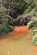
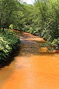
The entire Shamokin Creek is affected by pollution. This is mainly due to high levels of metals from old mines. This pollution is called abandoned mine drainage. The creek is also affected by waste water and other pollutants.
Even though cleaner streams join Shamokin Creek downstream, the pollution still reaches its mouth in Sunbury. There are many places where polluted water from old mines flows into the creek, especially in its upper parts.
The water in Shamokin Creek can be quite acidic, especially near Sunbury. In the upper parts, the water's pH (a measure of acidity) is usually between 6.1 and 6.6. A pH of 7 is neutral. Lower numbers mean more acidic.
In 1917, a report called Shamokin Creek the "worst stream" in the Coal Region. This was because of mine water, coal waste, and other issues. At that time, there was so much coal waste in the creek that people could even collect coal from its bed to sell. The creek was often black along its whole length.
Geography and Geology
The mouth of Shamokin Creek is about 427 feet (130 m) above sea level. Its source is higher, between 1060 and 1080 feet (320 and 330 m) above sea level. This means the creek flows downhill. The creek drops about 34.8 feet per mile (6.59 m/km) between Mount Carmel and Shamokin. Further downstream, it drops less steeply, about 13.5 feet per mile (2.56 m/km).
The area around Shamokin Creek is part of the Appalachian Mountains. The lower parts of the watershed have rolling hills. The creek cuts through Big Mountain and Little Mountain north of Shamokin. The upper parts of the watershed have areas changed by mining. Even though mining only happened in the upper third of the watershed, iron from the mines stains the creek bed for much of its length.

The creek's path is winding. It flows through areas with sandstone, shale, and lots of anthracite coal. There are also piles of coal waste along the creek. In Shamokin, the creek flows between stone walls. The upper 51.5 square miles (133 km2) of the watershed are in a major coal field. Almost all of the 34 coal layers in the watershed have been mined.
Shamokin Creek has many rapids for about 2 miles (3.2 km) downstream from Shamokin. Most of these rapids are easy to canoe. However, there is one difficult, rocky rapid near the Glen Burn Colliery. Further downstream, the rapids become less common.
Shamokin Creek's Watershed

The area that drains into Shamokin Creek is called its watershed. It covers 137 square miles (350 km2). The creek's mouth is in Sunbury. Its source is in Mount Carmel. The watershed includes parts of 14 towns.
There are 413 miles (665 km) of streams in the Shamokin Creek watershed. About 113 miles (182 km) of these streams are polluted by old mine drainage. In Mount Carmel, the creek helps carry stormwater. In the past, it also carried waste water from homes and mines.
Most of the land in the watershed is covered by forests (61%) or farms (32%). Only a small part (7%) is bare land or city areas. However, in the upper 54 square miles (140 km2) of the watershed, the land is mostly forests (57%) and areas changed by mining (38%). Only a small amount is city land (5%) or farmland (less than 1%).
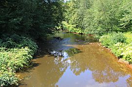
Near the upper parts of Shamokin Creek, the land is used for businesses and factories. There is often trash along the creek banks. Further downstream, the creek flows through a wide flat area. But it is still affected by buildings and coal waste. Downstream of Snydertown, the area around the creek is mostly forests and farms, not affected by development or mining.
Pennsylvania Route 61 follows the main part of Shamokin Creek for much of its length.
History of Shamokin Creek
Shamokin Creek was officially named on August 2, 1979. It is also known as Great Shamokin Creek and Middle Branch Shamokin Creek. The name "Shamokin" comes from a Delaware word meaning "Eel Creek."
Many early settlers in the Shamokin Creek valley were Scotch-Irish. The first mill in Northumberland County was built near the creek in 1774. A road was being built along the creek's valley by 1775. The first coal in Shamokin was found in Shamokin Creek itself.
Before the War of 1812, Abraham Cherry built a sawmill on the creek. Some coal mining was happening by 1825. A dam was built on the creek in Shamokin in 1826. In the early 1830s, the only canal boat on Shamokin Creek was launched.
In the early 1900s, the main jobs in the Shamokin Creek area were coal mining, making metal products, producing nails, agriculture, and making silk and wool. The creek's water also powered small mills. The Pennsylvania Railroad used the creek for its water supply.
Major towns in the watershed in the early 1900s included Shamokin, Mount Carmel, and Sunbury. Railroads like the Pennsylvania Railroad and the Philadelphia and Reading Railroad followed the creek.
Shamokin Creek was affected by coal mine waste as early as the early 1900s. Coal mining was a big industry here. Even though coal production was highest in 1917, mining still happens today. Most mines closed by 1960. However, as of 2001, there were still over 20 mining permits in the watershed.

A bridge called the Shamokin Creek Bridge carries Pennsylvania Route 61 over the creek in Sunbury. It was built in 1933.
In 1996, the Shamokin Creek Restoration Alliance was started. Its goal is to help clean up areas affected by old mines in the Shamokin Creek watershed.
Many grants have been given to help restore the creek. For example, in 1999, the Northumberland County Conservation District received $52,830 to study the creek. In 2002, the Northumberland County Planning Commission received $75,000 to remove sources of pollution. In 2003, more than $500,000 was given to fix abandoned mine drainage problems.
A project to control floods was done on Shamokin Creek in Mount Carmel in 2013.
Animals in Shamokin Creek
The main part of Shamokin Creek is a good place for warmwater fish. It's also a place for fish that travel to lay eggs. However, all of the smaller streams that flow into Shamokin Creek are designated for coldwater fish.
The very top of Shamokin Creek has no aquatic life. But further downstream, the creek is home to six types of fish.
In 2001, researchers found 169 individual fish from eight different species in Shamokin Creek at Shamokin. The most common fish were white suckers, creek chubs, and spotfin shiners. Other fish included pumpkinseeds, green sunfish, yellow bullhead, stonerollers, and even one rainbow trout.
Near Sunbury, 112 individual fish from 14 different species were found. The most common were smallmouth bass, fallfish, and white suckers. Less common ones included pumpkinseeds, chain pickerel, and spotfin shiners.
In the past, Shamokin Creek had many pike, sunfish, suckers, and eels.
Many areas in the upper parts of Shamokin Creek have very few or no small water bugs (macroinvertebrates). This is because metals from the mines cover the streambed.
Fun on Shamokin Creek
You can go canoeing on 21.6 miles (34.8 km) of Shamokin Creek. The best time to go is when snow is melting or within two days after heavy rain.
Pennsylvania State Game Lands Number 165 is partly in the Shamokin Creek watershed. This is a place where people can enjoy nature and wildlife.
Gallery
-
Shamokin Creek from State Route 2034
-
Above Quaker Run
-
At Millers Run
-
At Snydertown
-
At Sunbury


