Little Shamokin Creek facts for kids
Quick facts for kids Little Shamokin Creek |
|
|---|---|

Little Shamokin Creek
|
|

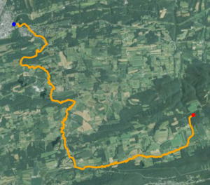
Satellite map of Little Shamokin Creek. The red dot is the stream's source and blue dot is its mouth.
|
|
| Physical characteristics | |
| Main source | Irish Valley |
| River mouth | Little Shamokin Creek near Sunbury 40°51′40″N 76°46′34″W / 40.86110°N 76.77616°W |
| Length | 15.0 mi (24.1 km) |
| Basin features | |
| River system | Susquehanna River |
| Basin size | 37 sq mi (96 km2) |
| Tributaries |
|
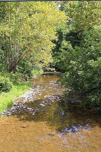
Little Shamokin Creek is a stream in Northumberland County, Pennsylvania. It is about 15 miles (24 km) long. This creek flows into Shamokin Creek, which then flows into the larger Susquehanna River.
The area of land that drains into Little Shamokin Creek is called its watershed. This watershed covers 37 square miles (96 square kilometers). It includes parts of four townships: Upper Augusta, Lower Augusta, Rockefeller, and Shamokin.
Little Shamokin Creek is special because it's the only stream in the Shamokin Creek area where fish can still live. This was true as of 1999.
Contents
Where Little Shamokin Creek Flows
Little Shamokin Creek begins in the eastern part of Northumberland County. This is a few miles north of a town called Trevorton.
From its start, the creek flows west through a place known as the Irish Valley. After leaving the valley, it reaches the Augustaville Church. Here, the creek changes direction and turns north. It continues flowing north until it joins with Shamokin Creek.
The Land Around the Creek
Little Shamokin Creek is located in the ridge-and-valley part of the Appalachian Mountains. The place where the creek starts, called its headwaters, is about 960 feet (290 meters) higher than where it ends, called its mouth. The highest parts of the watershed are in the southeastern area, near Little Mountain.
Most of the rocks (90%) in the upper part of the Little Shamokin Creek watershed are sedimentary rocks. These are rocks formed from layers of sediment. The other 10% of the rocks are sandstone.
The main type of soil in the watershed is called the Berks-Weikert-Bedington series. This soil is a mix of shale and silt and is found in the lower areas. Other soil types also exist, like the Leck Kill-Meckesville-Calvin series and the Hazelton-Dekalb-Buchanan series. These different soils are found in specific bands across the watershed.
There are also different rock formations in the area. The Hamilton Group formation is in the northern part of the watershed. South of that is the Spechty Kopf formation. Further south are parts of the Irish Valley formation. The Buddy Run formation is in the very southern part of the watershed.
The banks of Little Shamokin Creek have a lot of erosion. This means the soil and rock are wearing away. There's also a popular fishing spot about 3 feet (0.91 meters) deep that is also experiencing erosion.
Water Quality and Flow
The water in Little Shamokin Creek has low levels of dissolved oxygen. This is important for fish and other water creatures to breathe.
The watershed gets about 44.5 inches (113 cm) of rain each year. About 0.23 inches (5.8 mm) of this rain runs off the land into the creek annually. The creek carries a lot of sediment (like dirt and small rocks) and phosphorus each day.
In 1913, the Sunbury Water Company used Little Shamokin Creek as a source of drinking water for Sunbury. A dam was built on the creek, about 1 mile (1.6 km) east of Sunbury. This dam created five reservoirs, which are large storage areas for water. These reservoirs held millions of gallons of water for the town.
The Creek's Surroundings
The watershed of Little Shamokin Creek covers 37 square miles (96 square kilometers). A large part of this area, about 65%, is covered by forests. These forests include tree farms and groups of trees that lose their leaves in the fall.
About 30% of the watershed is used for agriculture. This means there are farms in the area. The remaining 2% of the watershed is urban or developed land, like towns and buildings.
Pennsylvania Route 890 is a main road that runs through the Little Shamokin Creek watershed. Many smaller township roads also provide access to the creek and its smaller streams.
History of the Area
Over the years, several watermills were built along Little Shamokin Creek and its smaller streams. These mills used the power of the water to grind grain or saw wood.
- Miller's Mill was first built in the 1790s by Colonel Thomas Jones. Another mill was built in the same spot in 1850.
- Shipman's Mill was also on the creek and was built by Abraham Shipman in 1850.
- Fagley's Mill was built in 1856 by Samuel Lantz on a smaller stream that flows into the creek.
The first public road in the valley of Little Shamokin Creek was built a long time ago, in 1787.
Smaller Streams Flowing In
Plum Creek is the only named smaller stream, or tributary, that flows into Little Shamokin Creek. There are other unnamed smaller streams that also join the creek.
Animals and Plants
In some farming areas near Little Shamokin Creek, there isn't much riparian buffer. This is a strip of plants and trees along the stream bank that helps protect the water. Also, farm animals like livestock can easily get into the creek in some places. There are beef and pork farms near the creek.
These farms can affect the creek's health. Because of this, the Department of Environmental Protection has said the creek is "impaired." This means its water quality isn't as good as it should be.
However, some good signs show the creek is getting better. Water-penny beetles, which are a type of insect, have been seen in the creek. This suggests the creek is recovering from being biologically impaired. But there is still siltation in the creek. Siltation is when fine dirt and mud build up, which can harm the food chain for animals living in the water.
Little Shamokin Creek is part of a larger area where people can fish for trout. Other streams in this fishing area include South Branch Roaring Creek and Mahantango Creek.
Fun and Recreation
A special area of 25.5 acres (10.3 hectares) along Little Shamokin Creek in Rockefeller Township has been turned into a place for recreation. This project was done by the Little Shamokin Creek Watershed Association. This was the very first public recreational area in that township. As of August 20, 2012, the recreational area was almost finished.
 | Precious Adams |
 | Lauren Anderson |
 | Janet Collins |

