
North Branch Shamokin Creek facts for kids
Quick facts for kids North Branch Shamokin Creek |
|
|---|---|

North Branch Shamokin Creek
|
|
| Other name(s) | Beaver Creek |
| Physical characteristics | |
| Main source | valley near Big Mountain, in Wilburton Number Two, in Conyngham Township, Columbia County, Pennsylvania between 1,480 and 1,500 feet (450 and 460 m) |
| River mouth | Shamokin Creek in Mount Carmel Township, Northumberland County, Pennsylvania 1,027 ft (313 m) 40°47′30″N 76°26′29″W / 40.7916°N 76.4413°W |
| Length | 4.8 mi (7.7 km) |
| Basin features | |
| Progression | Shamokin Creek → Susquehanna River → Chesapeake Bay |
| Basin size | 5.73 sq mi (14.8 km2) |
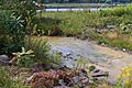
North Branch Shamokin Creek, also known as Beaver Creek, is a small river in Pennsylvania, United States. It flows for about 4.8 miles (7.7 km) through Columbia County and Northumberland County. This creek is a tributary of Shamokin Creek.
The land area that drains into the creek, called its watershed, is about 5.73 square miles (14.8 km2). Unfortunately, the creek's water is not very clean. It has metals from old, abandoned mines. The water is also quite acidic, but its quality has been slowly getting better. There are old underground mines in the area, and sometimes the creek's water even disappears into the ground!
Contents
Where Does the Creek Flow?
North Branch Shamokin Creek starts in a valley near Big Mountain. This is in a place called Wilburton Number Two in Conyngham Township, Columbia County.
The creek flows west-southwest through the valley for over a mile. Then, it leaves Columbia County and enters Mount Carmel Township in Northumberland County.
It continues flowing west-southwest for more than a mile. Along the way, it passes through two lakes. After that, it turns south-southwest. The creek then flows near the towns of Strong and Atlas.
The creek turns southeast and crosses Pennsylvania Route 61. For a short distance, it flows next to Pennsylvania Route 54 and Green Ridge. It then crosses Route 54 again and slowly turns west-southwest. A bit further downstream, the creek joins Shamokin Creek.
North Branch Shamokin Creek meets Shamokin Creek about 29.96 miles (48.22 km) upstream from where Shamokin Creek ends.
Water Quality and What's in the Water

The entire North Branch Shamokin Creek has poor water quality. It's considered an "impaired waterbody." This means it's not healthy due to metals and pollution from abandoned mine drainage. The creek is also affected by flow loss, where its water sinks into the ground. This can make it an ephemeral stream, meaning it sometimes dries up.
The creek's water is acidic, especially when the water level is low. However, its pH has been slowly increasing, which is a good sign. The average pH has gone from 3.2 to 3.7, meaning it's becoming less acidic.
The water contains different substances:
- It has high levels of manganese and iron.
- There's also aluminum in the water.
- The creek has sulfate and chloride from the mines.
- It also contains dissolved oxygen, nitrogen, ammonia, and carbon dioxide.
Land and Rocks Around the Creek
The mouth of North Branch Shamokin Creek is about 1,027 feet (313 m) above sea level. Its source is even higher, between 1,480 and 1,500 feet (450 and 460 m) above sea level.
The creek flows between two ridges called Red Ridge and Green Ridge. The area around the creek has a lot of coal. One coal bed where the creek flows is very thick, up to 14 feet (4.3 m).
There are many underground mine systems in the creek's watershed. Some of the water from these mines flows into the creek. Interestingly, some of the creek's water can disappear and even reappear in other nearby creek systems like Mahanoy Creek or Quaker Run.
The bottom of North Branch Shamokin Creek is covered with a reddish-brown layer. This is from iron that has settled out of the water. The creek bed is also "permeable," meaning water can easily soak through it.
The Creek's Watershed
The watershed of North Branch Shamokin Creek covers an area of 5.73 square miles (14.8 km2). The mouth of the creek is near Mount Carmel, while its source is near Ashland. Towns in the watershed include Marion Heights and Strong.
In the past, there were no raw sewage discharges directly into North Branch Shamokin Creek. In 2009, a company asked for permission to release stormwater into the creek during construction.
History of the Creek
North Branch Shamokin Creek was officially named and added to a national information system in 1979. It has also been known as Beaver Creek for a long time.
A colliery (a coal mine and its buildings) called Richards Colliery used to release waste water into North Branch Shamokin Creek. This colliery was very active, processing thousands of tons of coal each month.
A bridge carrying Pennsylvania Route 61 was built over the creek in 2008 near Atlas. This bridge is 53.2 feet (16.2 m) long.
In 2006 and 2007, a project worked to remove piles of waste rock in the creek's watershed. The goal was to make the water cleaner by reducing pollution from old mines. In the early 1900s, the old path of the creek was filled with rocks and culm (waste coal).
Animals and Plants in the Creek
The area around North Branch Shamokin Creek is meant to be a "Coldwater Fishery" and a "Migratory Fishery." This means it should be a good place for fish that like cold water and for fish that travel.
However, in 1999, scientists tried to find fish in the creek using a method called electrofishing, but they didn't find any. The creek is not stocked with fish by the Pennsylvania Fish and Boat Commission.
Because the water is so acidic, the creek cannot support aquatic life, including fish and small water creatures called macroinvertebrates.
Interestingly, algae can grow well in some deep mine discharges in the watershed. This happens because there are no animals to eat the algae.
Images for kids
-
North Branch Shamokin Creek
-
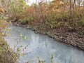
North Branch Shamokin Creek along Route 54 in Mount Carmel Township, PA.
