
Mahanoy Creek facts for kids
Quick facts for kids Mahanoy Creek |
|
|---|---|

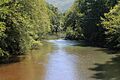
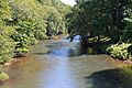
Mahanoy Creek in Little Mahanoy Township, Northumberland County
|
|
| Country | United States |
| State | Pennsylvania |
| Counties | Northumberland and Schuylkill |
| Physical characteristics | |
| Main source | Mahanoy Township, Schuylkill County, Pennsylvania |
| River mouth | Susquehanna River in Jackson Township, Northumberland County, Pennsylvania 40°43′22″N 76°50′37″W / 40.7228°N 76.8435°W |
| Length | 51.6 mi (83.0 km) |
| Basin features | |
| Progression | Susquehanna River, Chesapeake Bay |
| Basin size | 157 sq mi (410 km2) |
| Tributaries |
|
Mahanoy Creek is a stream that flows for about 51.6 miles (83.0 kilometers) in Pennsylvania. It is a tributary of the Susquehanna River. The creek runs through Northumberland and Schuylkill counties.
For many years, anthracite coal was mined in the area around Mahanoy Creek. This mining caused pollution, known as acid mine drainage. There are at least 35 places where this polluted water flows into the creek's watershed. Some parts of the creek, like Schwaben Creek and Little Mahanoy Creek, are still clean. These clean areas have more types of fish.
Groups like the Mahanoy Creek Watershed Association are working to clean up the creek. They have built special systems to treat the polluted water.
Contents
The Creek's Journey


Mahanoy Creek begins in strip mines in eastern Schuylkill County. It starts near Buck Mountain. The creek flows west, passing under Pennsylvania Route 54. Then it enters Mahanoy City, where it meets North Mahanoy Creek.
The creek continues west through more strip mines. It flows past towns like St. Nicholas and Boston Run. Then it reaches Gilberton, passing under Pennsylvania Route 924. After Gilberton, the creek enters Butler Township.
In Butler Township, Mahanoy Creek flows through Girardville and picks up Shenandoah Creek. It then goes through Ashland. After Ashland, the creek turns south through a gap in Ashland Mountain, leaving the strip mines behind.
At Gordon, Little Mahanoy Creek joins the main stream. The creek then meanders west through Barry Township and Eldred Township. It flows along the northern side of a mountain in Weiser State Forest.
Mahanoy Creek in Northumberland County
Mahanoy Creek enters Northumberland County in East Cameron Township. It flows west through a valley, with Line Mountain to the south and Mahanoy Mountain to the north. The creek passes under Pennsylvania Route 125.
It then flows into West Cameron Township and Little Mahanoy Township. Here, it meets Zerbe Run. Mahanoy Creek then turns southwest, passing by Dornsife. It cuts through a gap between Little Mountain and Line Mountain.
Finally, the creek enters Jackson Township. It picks up Schwaben Creek, its last tributary. Mahanoy Creek then flows west to join the Susquehanna River. This meeting point is north of Herndon.
What Are the Tributaries of Mahanoy Creek?
Mahanoy Creek has several smaller streams that flow into it, called tributaries. These include Little Mahanoy Creek, Schwaben Creek, Shenandoah Creek, North Mahanoy Creek, and Zerbe Run. Some smaller streams have local names, like "Big Run."
Only Schwaben Creek and Little Mahanoy Creek are not affected by acid mine drainage. North Mahanoy Creek starts from clean springs but flows through strip mines. Shenandoah Creek is polluted by sewage and mine drainage. Little Mahanoy Creek is clean because no mining has happened in its area.
Water Quality of Mahanoy Creek
The water in Mahanoy Creek contains high amounts of dissolved iron and aluminum. It also has small amounts of other metals like cobalt, nickel, copper, zinc, and lead. These come from the old coal mines.
There are more than 35 sources of polluted water, called acid mine drainage, flowing into the creek. The four biggest sources are the Locust Gap Tunnel, the Packer #5 Breach, the Packer #5 Borehole, and the Girard Mine seepage.
The water's acidity (pH) in the creek can vary a lot, from very acidic to nearly neutral. The amount of dissolved oxygen in the water also changes. This is important because fish and other water creatures need oxygen to live.
Polluted water from other areas, like the Shamokin Creek watershed, can also enter Mahanoy Creek through old mine tunnels. In some places, sewage from leaky systems also flows into the creek's smaller streams.
Land and Landscape Around Mahanoy Creek

The area around Mahanoy Creek is part of the Ridge-and-Valley Appalachians. This means there are many long, parallel ridges (mountains) and valleys. These ridges and valleys usually run in the same direction as the creek, from east to west.
The highest point in the Mahanoy Creek area is about 2,090 feet (637 meters) above sea level. The lowest point is 420 feet (128 meters) at the creek's mouth. The mountains are usually between 1,400 and 1,800 feet high, while the valleys are much lower.
Coal and Mining's Impact
The Mahanoy Creek watershed is known for its coal. There are 24 different coal beds underground. These coal beds are between 0.6 feet (0.2 meters) and 8.3 feet (2.5 meters) thick. Mining has happened very deep underground, over 2,500 feet (760 meters).
The mining has left its mark on the land. Some areas in the upper part of the watershed look like a "moonscape" because of all the mining. There are also many large piles of waste rock and dirt from mining, called spoil piles. In some places, buildings in the valley have been damaged because the ground sank due to underground mining.
The stream bed of Mahanoy Creek near Girardville has a reddish-brown crust made of iron. Even with this, some fish can still live in that area.
Mahanoy Creek Watershed


The Mahanoy Creek watershed covers 157 square miles (407 square kilometers). A watershed is all the land where water drains into a particular creek or river. This watershed is mostly in Schuylkill and Northumberland counties.
About 45,000 people live in the watershed. Most of the land is covered by forests (66%). Some is farmland (21%), some is mined land (9%), and some is developed (4%). However, the upper part of the creek has much more mined land (44%).
The Mahanoy Creek Watershed Association is a group working to improve the creek. They have turned a piece of land into a wetland called "The Swamp." This wetland helps clean the water naturally. They also organize cleanups in towns like Ashland and Girardville.
History of Mahanoy Creek
How Mahanoy Creek Got Its Name
The name "Mahanoy Creek" comes from an old word used by the Delaware Indian people. The word was "mahoni" or "maghonioy," which means "lick." This might refer to animals coming to the creek to lick salt from the ground. The town of Mahanoy City is also named after the creek.
Modern History and Mining
People started mining anthracite coal in the Mahanoy Creek area around 1840. This continued until about 1950. Even in the 21st century, some mines are still active, but they mostly reprocess old coal waste.
In the early 1900s, many coal processing plants drained their waste directly into the creek. By 1940, the banks of the creek were covered with a layer of coal silt up to 40 feet (12 meters) thick!
Efforts to Clean Up
To help clean up the creek, two special passive treatment systems have been built. These systems use natural processes to clean the polluted water. The Mahanoy Creek Aerobic Wetlands were created in 2000, and the Bolich Property Wetlands were created in 2006.
There is also a covered bridge over Mahanoy Creek called the Mahanoy Creek Bridge. It was built in 1940 and is about 152.9 feet (46.6 meters) long.
Animals in Mahanoy Creek
In 2000, scientists used a method called electrofishing to study the fish in the creek. They found twelve different types of fish. These included eastern blacknose dace, northern hognosed suckers, shiners, smallmouth bass, and rock bass.
A survey in 2001 found different numbers and types of fish in various parts of the creek. The mouth of the creek had many fish, with 14 species and 545 individual fish found. The tributary Schwaben Creek had even more, with 20 species and over 1,000 individual fish. This shows how important clean tributaries are for fish.
Some fish found in Mahanoy Creek and Schwaben Creek include White Suckers, swallowtail shiners, rosyface shiners, river chubs, banded darters, and shield darters. Brown trout, longnose dace, and eastern blacknose dace have also been seen. Long ago, deer used to come to the creek to lick salt.
Fun Activities at Mahanoy Creek
You can visit the Pennsylvania State Game Land Number 84, which is just south of Mahanoy Creek.
There's also a walking trail along the creek in Barry Township called the Sen. James J. Rhoades Nature Trail. It was named in honor of James J. Rhoades in 2010.
If you like fishing, you can do Catch and release fishing for smallmouth bass and largemouth bass in the creek.
Images for kids
-
Mahanoy Creek in Little Mahanoy Township, Northumberland County
-
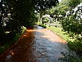
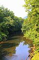
Mahanoy Creek in Girardville
-
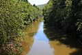
Mahanoy Creek in East Cameron Township, Northumberland County
-
Mahanoy Creek in East Cameron Township
-
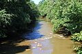
Mahanoy Creek near the Dornsife Gap
-
Mahanoy Creek looking upstream near its mouth, from Pennsylvania Route 147
