Zerbe Run facts for kids
Quick facts for kids Zerbe Run |
|
|---|---|

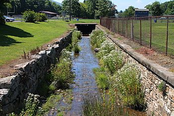
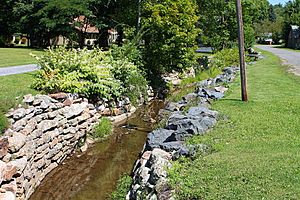
Zerbe Run looking downstream in Trevorton
|
|
| Other name(s) | Zerbe Creek |
| Physical characteristics | |
| Main source | 861 ft (262 m) |
| River mouth | Mahanoy Creek 509 ft (155 m) 40°45′16″N 76°45′25″W / 40.75456°N 76.75694°W |
| Length | 8.3 mi (13.4 km) |
| Basin features | |
| Progression | Mahanoy Creek → Susquehanna River → Chesapeake Bay |
| Basin size | 13.1 sq mi (34 km2) |
| Tributaries |
|
Zerbe Run (also called Zerbe Creek) is a small river, or tributary, in Northumberland County, Pennsylvania. It flows into Mahanoy Creek. Zerbe Run is about 8.3 miles (13.4 km) long. It travels through Coal Township, Zerbe Township, and Little Mahanoy Township.
The area of land that drains water into Zerbe Run is called its watershed. This watershed covers about 13.1 square miles (34 km2). Some parts of the stream are affected by old mine water. However, the higher parts of the stream are clean. Zerbe Run is an important part of the Mahanoy Creek river system.
Contents
Where Does Zerbe Run Flow?
Zerbe Run starts in a valley between two large mountains, Big Mountain and Little Mountain. This is in Coal Township. It flows west-southwest for a short distance. Then, it enters Zerbe Township and the town of Trevorton.
The stream continues flowing through Trevorton for a few miles. It passes through a pond and goes under Pennsylvania Route 890. Next, it turns west-northwest. It gets water from a small, unnamed stream on its left side. Then, it turns back to flow west-southwest. It crosses Pennsylvania Route 225 and flows beside it for several miles.
Zerbe Run then leaves Trevorton and Zerbe Township. It enters Little Mahanoy Township. Here, it turns southwest for over a mile. It receives two more unnamed streams from its left. The valley around the stream gets wider. Finally, Zerbe Run meets Mahanoy Creek. It joins Mahanoy Creek about 10.74 miles (17.28 km) before Mahanoy Creek ends.
Small Streams Joining Zerbe Run
Zerbe Run does not have any named smaller streams joining it. However, it has four unnamed streams that flow into it. The stream closest to its start is the longest of these four.
Water Quality of Zerbe Run
Some parts of Zerbe Run's watershed have water that is not clean. This is mainly because of abandoned mine drainage. This is water that flows out of old, unused mines. There are four places where mine water flows into the stream's watershed.
The effect of this mine water depends on how much clean water flows from the stream's higher parts. In 2001, Zerbe Run was found to be acidic when water levels were low. But it was almost neutral when water levels were high. There are also large piles of silt (fine dirt) along the stream near Trevorton. These piles are from mining activities.
In the early 1900s, the water in Zerbe Run was yellow because of sulfur pollution. However, a report from 1909 said that letting sewage (wastewater) flow into Zerbe Run at Trevorton would not harm public health.
Land and Rocks Around Zerbe Run
The place where Zerbe Run meets Mahanoy Creek is about 509 feet (155 m) above sea level. The very start of Zerbe Run is higher up, at about 861 feet (262 m) above sea level.
Long ago, a very thick coal layer, about 50 feet (15 m) deep, was found near Zerbe Run. The valley where Zerbe Run flows is between Big Mountain to the north and Little Mountain to the south. This valley is about 1 mile (1.6 km) wide and includes the town of Trevorton.
In the early 1900s, Zerbe Run was about 100 feet (30 m) wide and 3 feet (0.91 m) deep where it met Mahanoy Creek. It flowed at about 3 miles per hour (4.8 km/h). At that time, there were piles of waste coal, called culm banks, near the stream in Trevorton. There was also a stone dam on the stream, about 5 feet (1.5 m) high.
The stream starts from springs east of Trevorton. The higher parts of the stream's watershed are not affected by mining. But a mine water flow south of Trevorton pollutes the stream. This makes the stream quite polluted from Trevorton down to its mouth.
Zerbe Run's Watershed Area
The total area of land that drains into Zerbe Run is 13.1 square miles (34 km2). Zerbe Run is one of the main streams that feed into Mahanoy Creek. Its watershed makes up about 8.3% of the Mahanoy Creek drainage basin.
Most of the land affected by old mines in the watershed is south of the stream. There are also some swamps, marshes, lakes, and ponds in the watershed. Flooding can sometimes be a problem along Zerbe Run.
History and Fun Activities
Zerbe Run was officially added to the Geographic Names Information System in 1979. It is also known as Zerbe Creek. Some maps mistakenly called it "Zerbe Creek" in 1965. However, people living nearby and other records usually call it "Zerbe Run." It was once also called Little Mahanoy Creek, but there is another stream with that name.
In the past, there were mining operations near Zerbe Run in Trevorton. Many bridges have been built over Zerbe Run over the years. For example, a steel bridge carrying 8th Street in Trevorton was built in 1904. A concrete bridge for Pennsylvania Route 225 was built in 1934.
Part of Pennsylvania State Game Lands Number 165 is in the northeastern part of Zerbe Run's watershed. This area is used for outdoor activities like hunting and hiking.
Animals and Plants of Zerbe Run
The Zerbe Run watershed is a special area for fish. It is called a Coldwater Fishery and a Migratory Fishery. This means it's a good place for fish that like cold water and for fish that travel to lay eggs.
In 2001, scientists found many tiny water bugs, called macroinvertebrates, in the stream. They found them near Trevorton and Dornsife. However, they did not find any fish in the stream itself. Zerbe Run could be a good place to add trout for fishing. There is a lake in the watershed called the Zerbe Run Rod And Gun Club Pond. This pond is regularly filled with trout for fishing.
Many different types of macroinvertebrates live in Zerbe Run. Some, like Hydropsychidae (caddisflies) and Philopotamidae, were very common. Others, like Leuctridae (stoneflies) and Perlidae, were also common. The presence of these bugs helps scientists know how healthy the water is.
Many plants also grow along Zerbe Run. These include Grass-leaved rush, screw stem, and downy lettuce. You can also find Eastern hemlock, Red maple, Yellow birch, cinnamon fern, regal fern, and different types of sedges. Other plants like goldthread and mayflower also grow there.
A part of Zerbe Run near its start is listed on the Northumberland County Natural Areas Inventory. This means it is a special place for nature.
 | Ernest Everett Just |
 | Mary Jackson |
 | Emmett Chappelle |
 | Marie Maynard Daly |


