
Schwaben Creek facts for kids
Quick facts for kids Schwaben Creek |
|
|---|---|

Schwaben Creek looking upstream
|
|

Satellite map of Schwaben Creek. The red dot is the stream's source and blue dot is its mouth.
|
|
| Country | United States |
| State | Pennsylvania |
| County | Northumberland |
| Physical characteristics | |
| Main source | Upper Mahanoy Township, Northumberland County, Pennsylvania 800 feet (240 m) 40°43′04″N 76°36′48″W / 40.7179°N 76.6134°W |
| River mouth | Mahanoy Creek in Jackson Township, Northumberland County, Pennsylvania 480 feet (150 m) 40°43′06″N 76°47′36″W / 40.7183°N 76.7933°W |
| Length | 12.4 mi (20.0 km) |
| Basin features | |
| Basin size | 22.48 sq mi (58.2 km2) |
| Tributaries |
|
Schwaben Creek is a stream that flows into Mahanoy Creek in Northumberland County, Pennsylvania. It is about 12.4 miles (20 km) long. Schwaben Creek has two smaller streams, called tributaries, that flow into it: Middle Creek and Mouse Creek. Both of these join Schwaben Creek close to where it ends.
The creek flows through three areas: Upper Mahanoy Township, Washington Township, and Jackson Township. Most of the land around Schwaben Creek is used for farming or is covered by forests. In the past, special painted furniture was made in the valley of Schwaben Creek. The creek is located in a type of landscape known as the ridge-and-valley region.
Contents
Journey of the Creek

Schwaben Creek begins in Upper Mahanoy Township, south of a place called Line Mountain. The creek then flows west through a valley. It passes by small communities like Leck Kill and Greenbrier.
After leaving Upper Mahanoy Township, Schwaben Creek enters Washington Township. Here, it turns northwest and flows past Himmels Church. This is where its first tributary, Middle Creek, joins it. The creek then continues west past Rebuck and the Rebuck Church. It then turns southwest and then west again.
As it flows, the valley around the creek gets wider. It passes St. Peters Church before leaving Washington Township. Schwaben Creek then enters Jackson Township. Here, it bends south and its second tributary, Mouse Creek, joins it near the community of Red Cross. Finally, the creek turns northwest, flows under Pennsylvania Route 225, and then empties into Mahanoy Creek.
Smaller Streams Joining Schwaben Creek
- Middle Creek: This stream flows into Schwaben Creek about three-quarters of the way from where Schwaben Creek starts to where it ends.
- Mouse Creek: This stream joins Schwaben Creek very close to its end, about half a mile before Schwaben Creek flows into Mahanoy Creek. Mouse Creek drains an area of 7.1 square miles (18.4 square kilometers).
Area Around the Creek

The total area of land that drains into Schwaben Creek, called its watershed, is 22.48 square miles (58.2 square kilometers). This area includes parts of Washington Township and Upper Mahanoy Township. There are about 47.7 miles (76.8 km) of streams in this watershed.
Most of the land in the Schwaben Creek watershed is used for farming or is covered by forests:
- About 55% of the land is used for agriculture.
- Another 41% of the land is forests.
- A small part, about 3%, has "low-intensity development," which means there are some buildings or roads.
The Himmel's Church Covered Bridge, built in 1874, crosses Schwaben Creek near Rebuck.
Water Quality
Each day, about 30,085 pounds (13,646 kg) of sediment (like dirt and small rocks) are carried by Schwaben Creek. Most of this sediment comes from farm fields and stream banks.
The average amount of rainfall in the Schwaben Creek watershed over 19 years was about 39.3 inches (998 mm) per year. The average amount of runoff (water flowing over the land) was about 3.11 inches (79 mm) per year.
Most of the streams in the Schwaben Creek watershed are considered "impaired" by the Pennsylvania Department of Environmental Protection. This means their water quality is not as good as it should be. However, the very beginning (headwaters) of Middle Creek, a tributary of Schwaben Creek, is an exception and is not impaired.
Schwaben Creek is special because it is one of the few streams in the area that is not affected by mining activities.
Land and Rocks
The average height of the land in the Schwaben Creek watershed is about 819 feet (250 meters) above sea level. The entire area is part of the ridge-and-valley region. The rocks found on the surface are mostly sedimentary rocks that are layered together. The main type of soil in the area is called the C group.
Some parts of the streams in the Schwaben Creek watershed have Erosion channels and eroded streambanks. This happens when the soil and banks wear away, often due to water flow.
There is a rock formation in the watershed made of coarse white or light gray sandstone on top of a layer of buff and yellow colored rock.
History of the Area
Schwaben Creek was once known by other names, like Himmels Creek or Greenbriar Creek.
The name "Schwaben Creek" comes from a region in Germany called Swabia. This name was given by the early settlers in the area, who came from that part of Germany. There is another stream called Swabia Creek in Pennsylvania, but it is not connected to this one.
In the late 1700s and early 1800s, many pieces of furniture were made in the Schwaben Creek valley. These were created by Pennsylvania German people, including a furniture maker named Johannes Mayer. They made items like blanket chests, chests of drawers, and cupboards. A book from 2013 described this furniture as "the most exuberant and unique paint-decorated furniture."
In 1788, a road was built that ran east from Sunbury towards Paxtang Road. This road was about 10 miles (16 km) long.
Schwaben Creek has been recognized as an impaired watershed since 2002, meaning its water quality needs improvement.
Plants and Animals
Schwaben Creek is stocked with trout every year. This means young trout are added to the creek so people can fish for them. This happens between February 15 and July 31.
In some parts of the creek that are near farms, Livestock (like cows) can get into the water. Also, there are few or no riparian buffers in these farming areas. Riparian buffers are strips of plants and trees along the banks of a stream that help protect the water.
Near the community of Red Cross, there are twenty different kinds of fish known to live in Schwaben Creek.
Images for kids
-
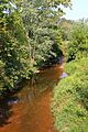
Schwaben Creek looking upstream
-
Satellite map of Schwaben Creek. The red dot is the stream's source and blue dot is its mouth.
