Mouse Creek (Schwaben Creek tributary) facts for kids
Quick facts for kids Mouse Creek |
|
|---|---|

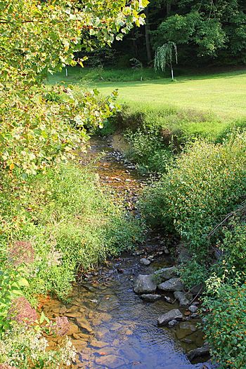
Mouse Creek looking upstream
|
|
| Physical characteristics | |
| Main source | valley in Jordan Township, Northumberland County, Pennsylvania 850 ft (260 m) |
| River mouth | Schwaben Creek in Washington Township, Northumberland County, Pennsylvania 476 ft (145 m) 40°42′49″N 76°47′10″W / 40.7136°N 76.7862°W |
| Length | 5.6 mi (9.0 km) |
| Basin features | |
| Progression | Schwaben Creek → Mahanoy Creek → Susquehanna River → Chesapeake Bay |
| Basin size | 7.19 sq mi (18.6 km2) |
| Tributaries |
|
Mouse Creek is a small stream, also called a tributary, located in Northumberland County, Pennsylvania. It flows into a larger stream called Schwaben Creek. Mouse Creek is about 5.6 miles (9.0 km) long.
The creek flows through several areas. These include Jordan Township, Washington Township, and Jackson Township. The entire area that drains water into Mouse Creek, called its watershed, covers about 7.19 square miles (18.6 km2). It's good to know that the creek and its smaller streams are considered clean. They are not listed as polluted waterways.
Contents
Where Mouse Creek Flows
Mouse Creek starts in a valley in Jordan Township. It flows generally west and then turns north. Along its journey, it picks up water from several smaller streams. These smaller streams are called unnamed tributaries.
The creek then flows through a narrow passage in the land. This passage is called a water gap. After this, it enters Washington Township. It continues through another valley, where it gets more water from another unnamed stream.
Mouse Creek crosses Pennsylvania Route 225 several times. It flows alongside this road through a narrow valley. Finally, Mouse Creek joins Schwaben Creek. This meeting point is about 0.48 miles (0.77 km) upstream from where Schwaben Creek ends.
Water Quality and Environment
Mouse Creek is known for its good water quality. No part of the creek is listed as polluted. This means the water is healthy for plants and animals.
Scientists have studied the water in Mouse Creek. They found that its temperature changes with the seasons. It can be cool in spring and warmer in summer. The water's pH level is usually slightly alkaline. This means it's a bit more basic than pure water.
The creek's watershed is partly in the Ridge-and-Valley Appalachians. This is a type of landscape with long, parallel ridges and valleys. The land around the creek is mostly covered by forests and farms. These land uses help keep the water clean.
Land and Landscape
Mouse Creek starts at an elevation of about 850 feet (260 m) above sea level. It ends at about 476 feet (145 m) above sea level. The highest points in the area around the creek are over 1,100 feet (340 m) high.
The ground in this area is made of different types of rock. One common rock is called schist. This is a type of rock that has been changed by heat and pressure. There are also mountains nearby, like Hooflander Mountain and Fisher Ridge. In the past, people found bluish-black limestone in quarries near the creek.
The area around Mouse Creek gets a good amount of rain each year. The average rainfall is about 39.30 inches (100 cm) per year.
The Mouse Creek Watershed
The watershed of Mouse Creek covers an area of 7.19 square miles (18.6 km2). A watershed is like a big bowl. All the rain and snow that falls into this bowl eventually flows into Mouse Creek.
The mouth of the creek is near a town called Red Cross. The creek's watershed is part of a larger watershed, the Mahanoy Creek basin. Mouse Creek is one of the important streams in the Mahanoy Creek area.
Most of the land in the upper part of the watershed is covered by forests. Forests help to filter the water and prevent soil from washing away. A large part of the land is also used for agriculture, like growing crops or raising animals. There are also some developed areas, but they make up a smaller part of the watershed.
History of Mouse Creek
Mouse Creek was officially named and recorded on August 2, 1979. Its official ID number is 1181976.
Over the years, many bridges have been built across Mouse Creek. These bridges help people and vehicles cross the creek safely. For example, a steel bridge carrying T-355 was repaired in 1994. Another concrete bridge for State Route 3003 was built in 1922. Many other bridges have been built and repaired over the decades.
Mouse Creek, like many other streams in the region, experienced flooding in June 1972. This was a time when a lot of rain caused rivers and creeks to overflow their banks.
Wildlife and Nature
Mouse Creek is a special place for fish. It is known as a Trout Stocked Fishery. This means that trout are released into the creek for fishing.
The creek has many riparian buffers. These are areas of trees and plants along the banks of the creek. They are very important because they help keep the water clean. They also provide homes for wildlife. The forested areas on the hills around the creek also help protect the water quality. Farmers in the watershed also use special methods, like contour cropping, to help prevent soil erosion.

