Coal Run (Shamokin Creek tributary) facts for kids
Quick facts for kids Coal Run |
|
|---|---|

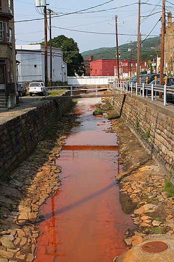
Coal Run looking downstream in Shamokin
|
|
| Physical characteristics | |
| Main source | lake in Mount Carmel Township, Northumberland County, Pennsylvania between 1,220 and 1,240 feet (370 and 380 m) |
| River mouth | Shamokin Creek in Shamokin, Northumberland County, Pennsylvania 725 ft (221 m) 40°47′29″N 76°33′11″W / 40.79132°N 76.55298°W |
| Length | 4.7 mi (7.6 km) |
| Basin features | |
| Progression | Shamokin Creek → Susquehanna River → Chesapeake Bay |
| Basin size | 6.25 sq mi (16.2 km2) |
Coal Run is a small stream, about 4.7 miles (7.6 km) long, in Northumberland County, Pennsylvania. It flows into Shamokin Creek. A stream that flows into a larger river is called a tributary.
Coal Run goes through Mount Carmel Township, Coal Township, and Shamokin. The area of land that drains into Coal Run is about 6.25 square miles (16.2 km2).
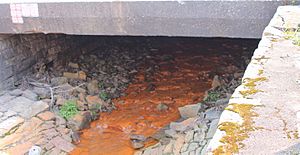
Sadly, Coal Run is known as an "impaired waterbody." This means its water quality is not good. The main problem is metals from old, unused coal mines, called abandoned mine drainage. Also, Coal Run is an ephemeral stream, which means it only flows sometimes, usually after rain or snowmelt. Most of the land around Coal Run used to be, or still is, involved in coal mining.
In the past, people built sawmills and coal mines along Coal Run. Many bridges also cross the stream. The area around Coal Run is important for fish, especially coldwater fish and fish that travel to different places (migratory fish). Long ago, trout used to live in this stream.
Contents
Where Does Coal Run Flow?
Coal Run starts in a lake in Mount Carmel Township. From there, it flows mostly east-southeast through a valley. After a short distance, it enters Coal Township.
The stream continues its journey, flowing east-southeast for more than a mile. Then, it turns south for a short bit before turning southwest. It then turns south again for a few tenths of a mile.
Next, Coal Run crosses Pennsylvania Route 61 and flows near the town of Ranshaw. It then turns and flows west-northwest, passing through Marshalton. Finally, it enters Shamokin.
In Shamokin, Coal Run flows west for a short distance. It then meets Shamokin Creek, joining it about 22.54 miles (36.27 km) upstream from where Shamokin Creek ends.
Water Quality of Coal Run
As mentioned, Coal Run is considered an "impaired waterbody." This means its water isn't as clean as it should be. The main reason for this is pollution from old coal mines, called abandoned mine drainage. This drainage adds metals to the water.
Even though it's affected by mine drainage, Coal Run's water is usually not too acidic. Its average pH is 6.5, which is close to neutral. Sometimes, though, it can be more acidic, with a pH as low as 4.8. The water in Coal Run often comes from discharges from old mines, like the Greenough, Nielson, and Luke Fidler mines. In the early 1900s, dirty water from many coal operations flowed into the stream.
Coal Run is an ephemeral stream. This means it doesn't flow all the time. It might dry up during dry periods and only flow after it rains or snows.
Scientists have measured the water in Coal Run. They found that its temperature usually ranges from 9.5 to 15.7 degrees Celsius (49.1 to 60.3 degrees Fahrenheit). The water can also contain total suspended solids (tiny bits of stuff floating in the water) and total dissolved solids (minerals and other things dissolved in the water).
Land and Rocks Around Coal Run
The land around Coal Run is mostly in the Coal Region of Pennsylvania. This means there are many coal deposits here. There are also many underground mine tunnels near the stream.
The elevation of Coal Run changes along its path. Where it starts, its elevation is between 1,220 and 1,240 feet (370 and 380 m) above sea level. Where it joins Shamokin Creek, its elevation is lower, at 725 feet (221 m) above sea level.
In the early 1900s, very fine waste coal, called culm, was carried into Coal Run from coal operations. Also, trash and dirty water used to enter the stream in Shamokin.
Coal Run's Watershed
The watershed of Coal Run is the entire area of land where all the rain and snowmelt eventually drain into Coal Run. This area covers about 6.25 square miles (16.2 km2).
The mouth of Coal Run is located in the United States Geological Survey map area called Shamokin. However, its source is in the map area called Mount Carmel.
The government has decided that Coal Run's waters should be protected for coldwater fish and for fish that travel to different places (migratory fish).
History of Coal Run
Coal Run has been known for a long time. It was officially added to the Geographic Names Information System in 1979. It is also sometimes called Coal Run Creek.
In the early 1800s, a man named John C. Boyd built a sawmill on Coal Run. By 1825, people were already mining coal in the area. In 1828, Daniel Derk opened a mine near the stream. Sadly, he was injured there, becoming the first miner injured in Northumberland County.
A railroad bridge used to cross Coal Run. In the early 1900s, a company even asked for permission to build a plant to dig for coal on the stream's bank.
Many coal mines and cleaning plants, called collieries and washeries, were located in the Coal Run watershed in the early 1900s. These included the Hickory Ridge Colliery and the Luke Fiddler Colliery. Different coal companies owned these operations.
Several bridges have been built over Coal Run:
- A concrete bridge for State Route 2026 was built in 1938 in the village of Coal Run. It is 41.0 feet (12.5 m) long.
- Another concrete bridge for State Route 2017 was built in 1952 and fixed in 2007. This bridge is 30.8 feet (9.4 m) long and is in the village of Springfield.
- A concrete culvert bridge was built in 1970 about 2 miles (3.2 km) south of Paxinos. This bridge is 22.0 feet (6.7 m) long and carries State Route 8001.
Animals and Plants
The area around Coal Run is protected for fish that like cold water and for fish that migrate (travel) to different places. Long ago, around 1840, people said the stream was "filled with trout!"
 | James Van Der Zee |
 | Alma Thomas |
 | Ellis Wilson |
 | Margaret Taylor-Burroughs |


