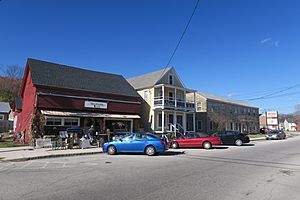
Troy (CDP), New Hampshire facts for kids
Quick facts for kids
Troy, New Hampshire
|
|
|---|---|

Chandler & Co.
|
|
| Country | United States |
| State | New Hampshire |
| County | Cheshire |
| Town | Troy |
| Area | |
| • Total | 1.28 sq mi (3.30 km2) |
| • Land | 1.28 sq mi (3.30 km2) |
| • Water | 0.00 sq mi (0.00 km2) |
| Elevation | 1,014 ft (309 m) |
| Population
(2020)
|
|
| • Total | 1,108 |
| • Density | 868.34/sq mi (335.34/km2) |
| Time zone | UTC-5 (Eastern (EST)) |
| • Summer (DST) | UTC-4 (EDT) |
| ZIP code |
03465
|
| Area code(s) | 603 |
| FIPS code | 33-77300 |
| GNIS feature ID | 2629742 |
Troy is a small community in New Hampshire, United States. It's known as a census-designated place (CDP). This means it's a specific area that the government counts for population, but it's not a separate city or town. Troy CDP is the main village within the larger town of Troy.
You can find Troy in Cheshire County. In 2020, about 1,108 people lived in the CDP. The whole town of Troy had a population of 2,130 people. The heart of the CDP is the Troy Village Historic District.
Exploring Troy's Geography
This CDP is located right in the middle of the town of Troy. It sits in a valley near the South Branch Ashuelot River. Smaller streams like Rockwood Brook and Nester Brook also join the river here. All these waters flow into the larger Connecticut River system.
The CDP stretches north along Marlboro Road. On its western side, it includes homes on Old Whitcomb Road and Deacon's Lane. It then goes down Milind Lane to High Street and Richmond Road. The border turns southeast along a small brook to Nester Brook, following it east to Rockwood Brook.
The CDP's border also runs south along Rockwood Brook. It then cuts east, south of Memorial Drive, to Main Street. From there, it follows Main Street south to a power line near the Fitzwilliam town line. The eastern part of the CDP follows the South Branch of the Ashuelot River north. It goes all the way to Monadnock Street near the town center. Then it follows Dort Street before returning to the South Branch and the old railroad line back to Marlboro Road.
New Hampshire Route 12 is the main road that goes through Troy. This road can take you about 9 miles (14 km) northwest to Keene. If you head southeast, it's about 12 miles (19 km) to Winchendon, Massachusetts.
The U.S. Census Bureau states that the Troy CDP covers a total area of 1.28 square miles (3.3 square kilometers). All of this area is land, except for the small streams and rivers.
Who Lives in Troy? (Demographics)
| Historical population | |||
|---|---|---|---|
| Census | Pop. | %± | |
| 2010 | 1,221 | — | |
| 2020 | 1,108 | −9.3% | |
| U.S. Decennial Census | |||
Let's look at the people who live in Troy. In 2010, there were 1,221 people living in the CDP. These people lived in 491 households, and 308 of these were families. There were 528 housing units in total. About 7% of these homes were empty.
Most people in Troy are White (96.5%). A small number are African American (0.9%), Native American (1.3%), or Asian (1.0%). About 1.1% of the population identified as Hispanic or Latino.
In 2010, about 34.4% of households had children under 18 living with them. Many households (44.6%) were married couples living together. About 13.6% had a female head of household with no husband present. Also, 37.3% of households were not families.
About 28.5% of all households were made up of individuals living alone. And 8.9% of these were people aged 65 or older living by themselves. On average, each household had 2.49 people. Families, on average, had 3.06 people.
About 25.6% of the people in Troy CDP were under 18 years old. About 11.0% were 65 years or older. The average age of people in the CDP was 34.7 years.
From 2011 to 2015, the estimated average yearly income for a household was $55,677. For families, the average income was $56,500. The average income per person in the CDP was $29,768. About 13.1% of the population and 10.1% of families lived below the poverty line. This included 31.2% of people under 18 and 10.8% of people 65 or older.
See also
 In Spanish: Troy (condado de Cheshire) para niños
 | James B. Knighten |
 | Azellia White |
 | Willa Brown |


